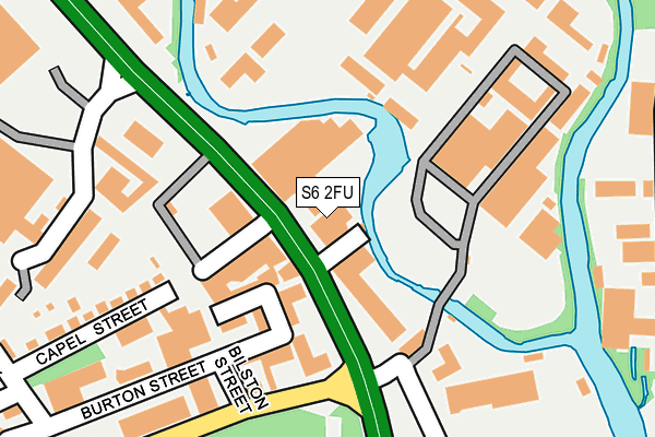
S6 2FU is located in the Hillsborough electoral ward, within the metropolitan district of Sheffield and the English Parliamentary constituency of Sheffield Central. The Sub Integrated Care Board (ICB) Location is NHS South Yorkshire ICB - 03N and the police force is South Yorkshire. This postcode has been in use since January 1980.


GetTheData
Source: OS OpenMap – Local (Ordnance Survey)
Source: OS VectorMap District (Ordnance Survey)
Licence: Open Government Licence (requires attribution)
| Easting | 433978 |
| Northing | 389531 |
| Latitude | 53.401533 |
| Longitude | -1.490424 |
GetTheData
Source: Open Postcode Geo
Licence: Open Government Licence
| Country | England |
| Postcode District | S6 |
| ➜ S6 open data dashboard ➜ See where S6 is on a map ➜ Where is Sheffield? | |
GetTheData
Source: Land Registry Price Paid Data
Licence: Open Government Licence
Elevation or altitude of S6 2FU as distance above sea level:
| Metres | Feet | |
|---|---|---|
| Elevation | 60m | 197ft |
Elevation is measured from the approximate centre of the postcode, to the nearest point on an OS contour line from OS Terrain 50, which has contour spacing of ten vertical metres.
➜ How high above sea level am I? Find the elevation of your current position using your device's GPS.
GetTheData
Source: Open Postcode Elevation
Licence: Open Government Licence
| Ward | Hillsborough |
| Constituency | Sheffield Central |
GetTheData
Source: ONS Postcode Database
Licence: Open Government Licence
| September 2023 | Violence and sexual offences | On or near Langsett Crescent | 384m |
| September 2023 | Violence and sexual offences | On or near Langsett Crescent | 384m |
| April 2023 | Burglary | On or near Langsett Crescent | 384m |
| ➜ Get more crime data in our Crime section | |||
GetTheData
Source: data.police.uk
Licence: Open Government Licence
| Burton Street (Penistone Road) | Hillfoot | 85m |
| Livesey Street (Penistone Road) | Owlerton | 255m |
| Bradfield Road (Penistone Road) | Owlerton | 286m |
| Hobson Avenue (Penistone Road) | Hillfoot | 291m |
| Bamforth Street (Langsett Road) | Langsett Estate | 338m |
| Bamforth Street (Sheffield Supertram) (Langsett Road) | Langsett Road | 325m |
| Hillsborough (Sheffield Supertram) (Langsett Road) | Hillsborough | 637m |
| Langsett - Primrose View (Sheffield Supertram) (Langsett Road) | Langsett Road | 644m |
| Hillsborough Park (Sheffield Supertram) (Middlewood Road) | Hillsborough | 937m |
| Malin Bridge (Sheffield Supertram) (Holme Lane) | Malin Bridge | 1,193m |
| Sheffield Station | 3.2km |
GetTheData
Source: NaPTAN
Licence: Open Government Licence
GetTheData
Source: ONS Postcode Database
Licence: Open Government Licence


➜ Get more ratings from the Food Standards Agency
GetTheData
Source: Food Standards Agency
Licence: FSA terms & conditions
| Last Collection | |||
|---|---|---|---|
| Location | Mon-Fri | Sat | Distance |
| 346 Langsett Road | 18:00 | 09:00 | 356m |
| W Morrisons | 17:30 | 09:00 | 420m |
| Regent Court Flats | 17:30 | 09:00 | 507m |
GetTheData
Source: Dracos
Licence: Creative Commons Attribution-ShareAlike
| Facility | Distance |
|---|---|
| Burton Street Foundation Burton Street, Sheffield Health and Fitness Gym, Sports Hall | 207m |
| The Sheffield College (Hillsborough Campus) Livesey Street, Sheffield Sports Hall, Health and Fitness Gym, Artificial Grass Pitch, Studio | 434m |
| Walkley Primary School (Closed) Burnaby Crescent, Sheffield Sports Hall | 692m |
GetTheData
Source: Active Places
Licence: Open Government Licence
| School | Phase of Education | Distance |
|---|---|---|
| Sacred Heart School, A Catholic Voluntary Academy Ripley Street, Sheffield, S6 2NU | Primary | 608m |
| Walkley Primary School Burnaby Crescent, Walkley, Sheffield, S6 2RZ | Primary | 735m |
| Rivelin Primary School Morley Street, Sheffield, S6 2PL | Primary | 1km |
GetTheData
Source: Edubase
Licence: Open Government Licence
| Risk of S6 2FU flooding from rivers and sea | Medium |
| ➜ S6 2FU flood map | |
GetTheData
Source: Open Flood Risk by Postcode
Licence: Open Government Licence
The below table lists the International Territorial Level (ITL) codes (formerly Nomenclature of Territorial Units for Statistics (NUTS) codes) and Local Administrative Units (LAU) codes for S6 2FU:
| ITL 1 Code | Name |
|---|---|
| TLE | Yorkshire and The Humber |
| ITL 2 Code | Name |
| TLE3 | South Yorkshire |
| ITL 3 Code | Name |
| TLE32 | Sheffield |
| LAU 1 Code | Name |
| E08000019 | Sheffield |
GetTheData
Source: ONS Postcode Directory
Licence: Open Government Licence
The below table lists the Census Output Area (OA), Lower Layer Super Output Area (LSOA), and Middle Layer Super Output Area (MSOA) for S6 2FU:
| Code | Name | |
|---|---|---|
| OA | E00041332 | |
| LSOA | E01008161 | Sheffield 026E |
| MSOA | E02001636 | Sheffield 026 |
GetTheData
Source: ONS Postcode Directory
Licence: Open Government Licence
| S6 2GA | Penistone Road | 58m |
| S6 2HH | Burton Street | 218m |
| S6 2HN | Capel Street | 221m |
| S6 2HP | Cuthbert Bank Road | 273m |
| S6 2UF | Langsett Road | 326m |
| S6 2HB | Blackburne Street | 332m |
| S6 2UE | Langsett Road | 334m |
| S6 2HA | Capel Street | 341m |
| S6 2FH | Clubmill Road | 343m |
| S6 2UG | Langsett Road | 366m |
GetTheData
Source: Open Postcode Geo; Land Registry Price Paid Data
Licence: Open Government Licence