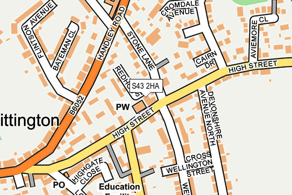
S43 2HA is located in the Whittington electoral ward, within the local authority district of Chesterfield and the English Parliamentary constituency of North East Derbyshire. The Sub Integrated Care Board (ICB) Location is NHS Derby and Derbyshire ICB - 15M and the police force is Derbyshire. This postcode has been in use since January 1992.


GetTheData
Source: OS OpenMap – Local (Ordnance Survey)
Source: OS VectorMap District (Ordnance Survey)
Licence: Open Government Licence (requires attribution)
| Easting | 439847 |
| Northing | 375600 |
| Latitude | 53.275910 |
| Longitude | -1.403902 |
GetTheData
Source: Open Postcode Geo
Licence: Open Government Licence
| Country | England |
| Postcode District | S43 |
| ➜ S43 open data dashboard ➜ See where S43 is on a map ➜ Where is Chesterfield? | |
GetTheData
Source: Land Registry Price Paid Data
Licence: Open Government Licence
Elevation or altitude of S43 2HA as distance above sea level:
| Metres | Feet | |
|---|---|---|
| Elevation | 90m | 295ft |
Elevation is measured from the approximate centre of the postcode, to the nearest point on an OS contour line from OS Terrain 50, which has contour spacing of ten vertical metres.
➜ How high above sea level am I? Find the elevation of your current position using your device's GPS.
GetTheData
Source: Open Postcode Elevation
Licence: Open Government Licence
| Ward | Whittington |
| Constituency | North East Derbyshire |
GetTheData
Source: ONS Postcode Database
Licence: Open Government Licence
| January 2024 | Violence and sexual offences | On or near Devonshire Road North | 413m |
| December 2023 | Violence and sexual offences | On or near Devonshire Road North | 413m |
| October 2023 | Violence and sexual offences | On or near Bluebank View | 476m |
| ➜ Get more crime data in our Crime section | |||
GetTheData
Source: data.police.uk
Licence: Open Government Licence
| The Wellington (High Street) | New Whittington | 22m |
| The Wellington (High Street) | New Whittington | 33m |
| Stone Lane | New Whittington | 48m |
| High Street | New Whittington | 65m |
| High Street | New Whittington | 94m |
| Chesterfield Station | 4.3km |
| Dronfield Station | 5.2km |
GetTheData
Source: NaPTAN
Licence: Open Government Licence
GetTheData
Source: ONS Postcode Database
Licence: Open Government Licence


➜ Get more ratings from the Food Standards Agency
GetTheData
Source: Food Standards Agency
Licence: FSA terms & conditions
| Last Collection | |||
|---|---|---|---|
| Location | Mon-Fri | Sat | Distance |
| New Whittington Post Office | 16:00 | 11:30 | 220m |
| Highland Road | 16:00 | 11:00 | 221m |
| 80 Brearley Avenue | 17:00 | 11:30 | 448m |
GetTheData
Source: Dracos
Licence: Creative Commons Attribution-ShareAlike
| Facility | Distance |
|---|---|
| Brearley Park Brearley Street, Old Whittington, Chesterfield Grass Pitches | 640m |
| Whittington Green School High Street, Old Whittington, Chesterfield Sports Hall, Grass Pitches | 1km |
| Handley Wood Golf Range Whittington Road, Barrow Hill, Chesterfield Golf | 1.2km |
GetTheData
Source: Active Places
Licence: Open Government Licence
| School | Phase of Education | Distance |
|---|---|---|
| New Whittington Community Primary School London Street, New Whittington, Chesterfield, S43 2AQ | Primary | 267m |
| Whittington Green School High Street, Old Whittington, Chesterfield, S41 9LG | Secondary | 986m |
| Mary Swanwick Primary School Church Street North, Old Whittington, Chesterfield, S41 9QW | Primary | 1.5km |
GetTheData
Source: Edubase
Licence: Open Government Licence
The below table lists the International Territorial Level (ITL) codes (formerly Nomenclature of Territorial Units for Statistics (NUTS) codes) and Local Administrative Units (LAU) codes for S43 2HA:
| ITL 1 Code | Name |
|---|---|
| TLF | East Midlands (England) |
| ITL 2 Code | Name |
| TLF1 | Derbyshire and Nottinghamshire |
| ITL 3 Code | Name |
| TLF12 | East Derbyshire |
| LAU 1 Code | Name |
| E07000034 | Chesterfield |
GetTheData
Source: ONS Postcode Directory
Licence: Open Government Licence
The below table lists the Census Output Area (OA), Lower Layer Super Output Area (LSOA), and Middle Layer Super Output Area (MSOA) for S43 2HA:
| Code | Name | |
|---|---|---|
| OA | E00098760 | |
| LSOA | E01019527 | Chesterfield 003A |
| MSOA | E02004057 | Chesterfield 003 |
GetTheData
Source: ONS Postcode Directory
Licence: Open Government Licence
| S43 2AN | High Street | 58m |
| S43 2AT | Campbell Court | 61m |
| S43 2AW | High Street | 71m |
| S43 2EJ | Blay Court | 97m |
| S43 2DG | Stone Lane | 98m |
| S43 2EL | Ilford Court | 103m |
| S43 2BG | Wellington Street | 117m |
| S43 2BA | Bamford Street | 126m |
| S43 2EX | Cairn Drive | 127m |
| S43 2EF | Handley Road | 143m |
GetTheData
Source: Open Postcode Geo; Land Registry Price Paid Data
Licence: Open Government Licence