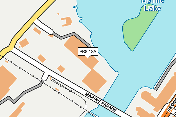
PR8 1SA is located in the Cambridge electoral ward, within the metropolitan district of Sefton and the English Parliamentary constituency of Southport. The Sub Integrated Care Board (ICB) Location is NHS Cheshire and Merseyside ICB - 01V and the police force is Merseyside. This postcode has been in use since August 2004.


GetTheData
Source: OS OpenMap – Local (Ordnance Survey)
Source: OS VectorMap District (Ordnance Survey)
Licence: Open Government Licence (requires attribution)
| Easting | 333319 |
| Northing | 417861 |
| Latitude | 53.652992 |
| Longitude | -3.010347 |
GetTheData
Source: Open Postcode Geo
Licence: Open Government Licence
| Country | England |
| Postcode District | PR8 |
| ➜ PR8 open data dashboard ➜ See where PR8 is on a map ➜ Where is Southport? | |
GetTheData
Source: Land Registry Price Paid Data
Licence: Open Government Licence
Elevation or altitude of PR8 1SA as distance above sea level:
| Metres | Feet | |
|---|---|---|
| Elevation | 10m | 33ft |
Elevation is measured from the approximate centre of the postcode, to the nearest point on an OS contour line from OS Terrain 50, which has contour spacing of ten vertical metres.
➜ How high above sea level am I? Find the elevation of your current position using your device's GPS.
GetTheData
Source: Open Postcode Elevation
Licence: Open Government Licence
| Ward | Cambridge |
| Constituency | Southport |
GetTheData
Source: ONS Postcode Database
Licence: Open Government Licence
| January 2024 | Public order | On or near Park/Open Space | 392m |
| November 2023 | Public order | On or near Park/Open Space | 392m |
| November 2023 | Anti-social behaviour | On or near Park/Open Space | 392m |
| ➜ Get more crime data in our Crime section | |||
GetTheData
Source: data.police.uk
Licence: Open Government Licence
| Victoria Street (Promenade) | Southport | 318m |
| Promenade (Nevill Street) | Southport | 376m |
| Bath Street (Nevill Street) | Southport | 386m |
| The Promenade (Leicester Steet) | Southport | 557m |
| Knowsley Road (Leicester Steet) | Southport | 567m |
| Southport Station | 0.9km |
| Birkdale Station | 2.1km |
| Meols Cop Station | 2.4km |
GetTheData
Source: NaPTAN
Licence: Open Government Licence
GetTheData
Source: ONS Postcode Database
Licence: Open Government Licence


➜ Get more ratings from the Food Standards Agency
GetTheData
Source: Food Standards Agency
Licence: FSA terms & conditions
| Last Collection | |||
|---|---|---|---|
| Location | Mon-Fri | Sat | Distance |
| 40 Seabank Road | 16:00 | 11:15 | 433m |
| Union Club | 16:15 | 11:15 | 463m |
| Bath Street | 16:15 | 11:15 | 504m |
GetTheData
Source: Dracos
Licence: Creative Commons Attribution-ShareAlike
| Facility | Distance |
|---|---|
| Victoria Leisure Promenade, Southport Swimming Pool, Health and Fitness Gym, Studio, Squash Courts | 375m |
| Everlast Gyms (Southport Ocean Plaza) Marine Parade, Southport Swimming Pool, Health and Fitness Gym, Studio | 399m |
| Spindles Health & Leisure (Southport) Lord Street, Southport Swimming Pool, Health and Fitness Gym, Studio | 607m |
GetTheData
Source: Active Places
Licence: Open Government Licence
| School | Phase of Education | Distance |
|---|---|---|
| Holy Trinity Church of England Primary School, Southport Manchester Road, Southport, PR9 9AZ | Primary | 968m |
| Southport Education Group Mornington Road, Southport, PR9 0TT | 16 plus | 987m |
| Arden College 40 Derby Road, Southport, PR9 0TZ | Not applicable | 1.1km |
GetTheData
Source: Edubase
Licence: Open Government Licence
| Risk of PR8 1SA flooding from rivers and sea | Low |
| ➜ PR8 1SA flood map | |
GetTheData
Source: Open Flood Risk by Postcode
Licence: Open Government Licence
The below table lists the International Territorial Level (ITL) codes (formerly Nomenclature of Territorial Units for Statistics (NUTS) codes) and Local Administrative Units (LAU) codes for PR8 1SA:
| ITL 1 Code | Name |
|---|---|
| TLD | North West (England) |
| ITL 2 Code | Name |
| TLD7 | Merseyside |
| ITL 3 Code | Name |
| TLD73 | Sefton |
| LAU 1 Code | Name |
| E08000014 | Sefton |
GetTheData
Source: ONS Postcode Directory
Licence: Open Government Licence
The below table lists the Census Output Area (OA), Lower Layer Super Output Area (LSOA), and Middle Layer Super Output Area (MSOA) for PR8 1SA:
| Code | Name | |
|---|---|---|
| OA | E00035197 | |
| LSOA | E01006950 | Sefton 004B |
| MSOA | E02001432 | Sefton 004 |
GetTheData
Source: ONS Postcode Directory
Licence: Open Government Licence
| PR9 0DX | Promenade | 359m |
| PR9 0DS | Promenade | 366m |
| PR9 0ES | Bold Street | 395m |
| PR9 0DY | Promenade | 406m |
| PR8 1SN | Promenade | 410m |
| PR8 1SP | Promenade | 410m |
| PR9 0DU | Victoria Street | 413m |
| PR9 0ED | Bold Street | 415m |
| PR9 0DR | Nevill Street | 418m |
| PR9 0DP | Bath Street | 433m |
GetTheData
Source: Open Postcode Geo; Land Registry Price Paid Data
Licence: Open Government Licence