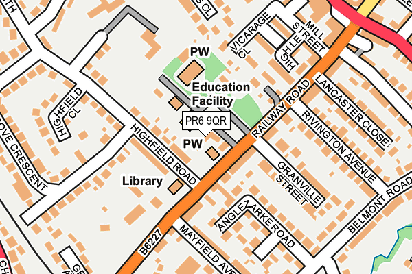
PR6 9QR is located in the Adlington & Anderton electoral ward, within the local authority district of Chorley and the English Parliamentary constituency of Chorley. The Sub Integrated Care Board (ICB) Location is NHS Lancashire and South Cumbria ICB - 00X and the police force is Lancashire. This postcode has been in use since August 1992.


GetTheData
Source: OS OpenMap – Local (Ordnance Survey)
Source: OS VectorMap District (Ordnance Survey)
Licence: Open Government Licence (requires attribution)
| Easting | 360362 |
| Northing | 413412 |
| Latitude | 53.615745 |
| Longitude | -2.600658 |
GetTheData
Source: Open Postcode Geo
Licence: Open Government Licence
| Country | England |
| Postcode District | PR6 |
| ➜ PR6 open data dashboard ➜ See where PR6 is on a map ➜ Where is Adlington? | |
GetTheData
Source: Land Registry Price Paid Data
Licence: Open Government Licence
Elevation or altitude of PR6 9QR as distance above sea level:
| Metres | Feet | |
|---|---|---|
| Elevation | 110m | 361ft |
Elevation is measured from the approximate centre of the postcode, to the nearest point on an OS contour line from OS Terrain 50, which has contour spacing of ten vertical metres.
➜ How high above sea level am I? Find the elevation of your current position using your device's GPS.
GetTheData
Source: Open Postcode Elevation
Licence: Open Government Licence
| Ward | Adlington & Anderton |
| Constituency | Chorley |
GetTheData
Source: ONS Postcode Database
Licence: Open Government Licence
| June 2022 | Criminal damage and arson | On or near Railway Road | 88m |
| June 2022 | Violence and sexual offences | On or near Anglezarke Road | 162m |
| June 2022 | Violence and sexual offences | On or near Mill Street | 209m |
| ➜ Get more crime data in our Crime section | |||
GetTheData
Source: data.police.uk
Licence: Open Government Licence
| Library (Railway Road) | Adlington | 47m |
| Library (Railway Road) | Adlington | 58m |
| Belmont Road (Railway Road) | Adlington | 222m |
| Railway Station (Railway Road) | Adlington | 254m |
| Railway Station (Railway Road) | Adlington | 267m |
| Adlington (Lancs) Station | 0.3km |
| Blackrod Station | 3.4km |
| Chorley Station | 4.4km |
GetTheData
Source: NaPTAN
Licence: Open Government Licence
| Percentage of properties with Next Generation Access | 100.0% |
| Percentage of properties with Superfast Broadband | 100.0% |
| Percentage of properties with Ultrafast Broadband | 0.0% |
| Percentage of properties with Full Fibre Broadband | 0.0% |
Superfast Broadband is between 30Mbps and 300Mbps
Ultrafast Broadband is > 300Mbps
| Percentage of properties unable to receive 2Mbps | 0.0% |
| Percentage of properties unable to receive 5Mbps | 0.0% |
| Percentage of properties unable to receive 10Mbps | 0.0% |
| Percentage of properties unable to receive 30Mbps | 0.0% |
GetTheData
Source: Ofcom
Licence: Ofcom Terms of Use (requires attribution)
GetTheData
Source: ONS Postcode Database
Licence: Open Government Licence


➜ Get more ratings from the Food Standards Agency
GetTheData
Source: Food Standards Agency
Licence: FSA terms & conditions
| Last Collection | |||
|---|---|---|---|
| Location | Mon-Fri | Sat | Distance |
| Tsb, Railway Road, Adlington | 17:15 | 10:30 | 89m |
| Higher Adlington Post Office | 17:15 | 09:15 | 299m |
| Grey Horse | 17:15 | 09:00 | 880m |
GetTheData
Source: Dracos
Licence: Creative Commons Attribution-ShareAlike
| Facility | Distance |
|---|---|
| Adlington St Paul's C Of E Primary School Railway Road, Adlington, Chorley Grass Pitches | 36m |
| King George V Playing Field (Adlington) Chorley Road, Adlington Grass Pitches | 417m |
| Fairview Highfield Road North, Adlington Grass Pitches | 420m |
GetTheData
Source: Active Places
Licence: Open Government Licence
| School | Phase of Education | Distance |
|---|---|---|
| Adlington St Paul's Church of England Primary School Railway Road, Adlington, Chorley, PR6 9QZ | Primary | 36m |
| Anderton Primary School Babylon Lane, Adlington, PR6 9NN | Primary | 315m |
| St Joseph's Catholic Primary School, Anderton Rothwell Road, Anderton, Chorley, PR6 9LZ | Primary | 523m |
GetTheData
Source: Edubase
Licence: Open Government Licence
The below table lists the International Territorial Level (ITL) codes (formerly Nomenclature of Territorial Units for Statistics (NUTS) codes) and Local Administrative Units (LAU) codes for PR6 9QR:
| ITL 1 Code | Name |
|---|---|
| TLD | North West (England) |
| ITL 2 Code | Name |
| TLD4 | Lancashire |
| ITL 3 Code | Name |
| TLD47 | Chorley and West Lancashire |
| LAU 1 Code | Name |
| E07000118 | Chorley |
GetTheData
Source: ONS Postcode Directory
Licence: Open Government Licence
The below table lists the Census Output Area (OA), Lower Layer Super Output Area (LSOA), and Middle Layer Super Output Area (MSOA) for PR6 9QR:
| Code | Name | |
|---|---|---|
| OA | E00126459 | |
| LSOA | E01024916 | Chorley 014B |
| MSOA | E02005202 | Chorley 014 |
GetTheData
Source: ONS Postcode Directory
Licence: Open Government Licence
| PR6 9RB | Railway Road | 58m |
| PR6 9QZ | Railway Road | 85m |
| PR6 9RE | Riding Street | 97m |
| PR6 9RH | Highfield Road | 109m |
| PR6 9QP | Vicarage Close | 132m |
| PR6 9QW | High Lea | 145m |
| PR6 9PY | Granville Street | 154m |
| PR6 9PZ | Anglezarke Road | 160m |
| PR6 9RF | Railway Road | 162m |
| PR6 9QA | Gidlow Avenue | 171m |
GetTheData
Source: Open Postcode Geo; Land Registry Price Paid Data
Licence: Open Government Licence