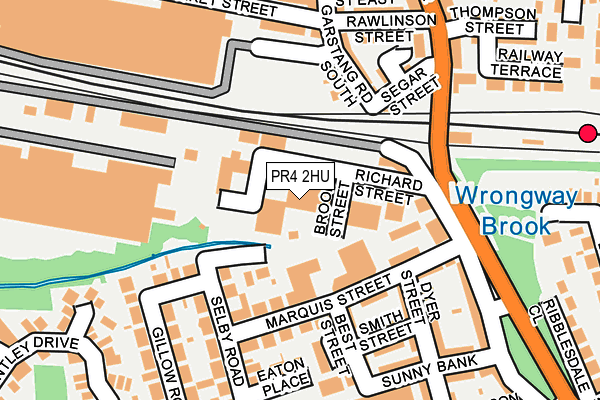
PR4 2HU lies on Richards Street in Kirkham, Preston. PR4 2HU is located in the Kirkham electoral ward, within the local authority district of Fylde and the English Parliamentary constituency of Fylde. The Sub Integrated Care Board (ICB) Location is NHS Lancashire and South Cumbria ICB - 02M and the police force is Lancashire. This postcode has been in use since January 1980.


GetTheData
Source: OS OpenMap – Local (Ordnance Survey)
Source: OS VectorMap District (Ordnance Survey)
Licence: Open Government Licence (requires attribution)
| Easting | 341755 |
| Northing | 432591 |
| Latitude | 53.786379 |
| Longitude | -2.885506 |
GetTheData
Source: Open Postcode Geo
Licence: Open Government Licence
| Street | Richards Street |
| Locality | Kirkham |
| Town/City | Preston |
| Country | England |
| Postcode District | PR4 |
| ➜ PR4 open data dashboard ➜ See where PR4 is on a map ➜ Where is Kirkham? | |
GetTheData
Source: Land Registry Price Paid Data
Licence: Open Government Licence
Elevation or altitude of PR4 2HU as distance above sea level:
| Metres | Feet | |
|---|---|---|
| Elevation | 20m | 66ft |
Elevation is measured from the approximate centre of the postcode, to the nearest point on an OS contour line from OS Terrain 50, which has contour spacing of ten vertical metres.
➜ How high above sea level am I? Find the elevation of your current position using your device's GPS.
GetTheData
Source: Open Postcode Elevation
Licence: Open Government Licence
| Ward | Kirkham |
| Constituency | Fylde |
GetTheData
Source: ONS Postcode Database
Licence: Open Government Licence
WARDEN CONSTRUCTION LTD, DAMAR HOUSE, RICHARDS STREET, KIRKHAM, PRESTON, PR4 2HU 2003 28 FEB £68,000 |
GetTheData
Source: HM Land Registry Price Paid Data
Licence: Contains HM Land Registry data © Crown copyright and database right 2024. This data is licensed under the Open Government Licence v3.0.
| August 2023 | Anti-social behaviour | On or near Brookside | 96m |
| June 2022 | Anti-social behaviour | On or near Sunny Bank | 199m |
| June 2022 | Anti-social behaviour | On or near Sunny Bank | 199m |
| ➜ Get more crime data in our Crime section | |||
GetTheData
Source: data.police.uk
Licence: Open Government Licence
| Railway Station (Station Road) | Kirkham | 170m |
| Rail Station (Station Road) | Kirkham | 177m |
| Everest Court (Market Street) | Wesham | 189m |
| Wyre Street (Station Road) | Wesham | 307m |
| Wyre Street (Station Road) | Wesham | 316m |
| Kirkham & Wesham Station | 0.2km |
| Moss Side Station | 4.5km |
| Salwick Station | 4.5km |
GetTheData
Source: NaPTAN
Licence: Open Government Licence
GetTheData
Source: ONS Postcode Database
Licence: Open Government Licence


➜ Get more ratings from the Food Standards Agency
GetTheData
Source: Food Standards Agency
Licence: FSA terms & conditions
| Last Collection | |||
|---|---|---|---|
| Location | Mon-Fri | Sat | Distance |
| Wesham Post Office | 17:00 | 09:45 | 343m |
| Sunnybank | 17:30 | 09:45 | 363m |
| Wesham Cross | 17:00 | 09:45 | 707m |
GetTheData
Source: Dracos
Licence: Creative Commons Attribution-ShareAlike
| Facility | Distance |
|---|---|
| Kirkham And Wesham Primary School Nelson Street, Kirkham, Preston Grass Pitches | 314m |
| Kirkham And Wesham Cricket Club Woodlands Avenue, Kirkham Grass Pitches | 322m |
| The Willows Catholic Primary School Victoria Road, Kirkham, Preston Grass Pitches | 442m |
GetTheData
Source: Active Places
Licence: Open Government Licence
| School | Phase of Education | Distance |
|---|---|---|
| Kirkham and Wesham Primary School Nelson Street, Kirkham, Preston, PR4 2JP | Primary | 314m |
| Medlar-with-Wesham Church of England Primary School Garstang Road North, Wesham, Preston, PR4 3DE | Primary | 397m |
| The Willows Catholic Primary School, Kirkham Victoria Road, Kirkham, Preston, PR4 2BT | Primary | 442m |
GetTheData
Source: Edubase
Licence: Open Government Licence
| Risk of PR4 2HU flooding from rivers and sea | Medium |
| ➜ PR4 2HU flood map | |
GetTheData
Source: Open Flood Risk by Postcode
Licence: Open Government Licence
The below table lists the International Territorial Level (ITL) codes (formerly Nomenclature of Territorial Units for Statistics (NUTS) codes) and Local Administrative Units (LAU) codes for PR4 2HU:
| ITL 1 Code | Name |
|---|---|
| TLD | North West (England) |
| ITL 2 Code | Name |
| TLD4 | Lancashire |
| ITL 3 Code | Name |
| TLD45 | Mid Lancashire |
| LAU 1 Code | Name |
| E07000119 | Fylde |
GetTheData
Source: ONS Postcode Directory
Licence: Open Government Licence
The below table lists the Census Output Area (OA), Lower Layer Super Output Area (LSOA), and Middle Layer Super Output Area (MSOA) for PR4 2HU:
| Code | Name | |
|---|---|---|
| OA | E00126939 | |
| LSOA | E01025009 | Fylde 002C |
| MSOA | E02005204 | Fylde 002 |
GetTheData
Source: ONS Postcode Directory
Licence: Open Government Licence
| PR4 2JX | Brookside | 91m |
| PR4 2HY | Marquis Street | 131m |
| PR4 3EA | Wright Street | 140m |
| PR4 2JD | Best Street | 151m |
| PR4 2JU | Sherburne Avenue | 157m |
| PR4 2LA | The Courtyard | 157m |
| PR4 3AT | Segar Street | 158m |
| PR4 3BH | Garstang Road South | 168m |
| PR4 2JA | Dyer Street | 169m |
| PR4 2JB | Smith Street | 170m |
GetTheData
Source: Open Postcode Geo; Land Registry Price Paid Data
Licence: Open Government Licence