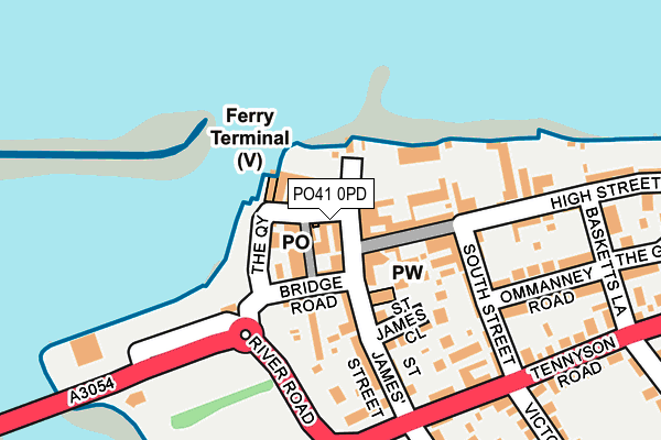
PO41 0PD is located in the Freshwater North & Yarmouth electoral ward, within the unitary authority of Isle of Wight and the English Parliamentary constituency of Isle of Wight. The Sub Integrated Care Board (ICB) Location is NHS Hampshire and Isle of Wight ICB - D9Y0V and the police force is Hampshire. This postcode has been in use since January 1980.


GetTheData
Source: OS OpenMap – Local (Ordnance Survey)
Source: OS VectorMap District (Ordnance Survey)
Licence: Open Government Licence (requires attribution)
| Easting | 435423 |
| Northing | 89734 |
| Latitude | 50.706170 |
| Longitude | -1.499719 |
GetTheData
Source: Open Postcode Geo
Licence: Open Government Licence
| Country | England |
| Postcode District | PO41 |
| ➜ PO41 open data dashboard ➜ See where PO41 is on a map ➜ Where is Yarmouth? | |
GetTheData
Source: Land Registry Price Paid Data
Licence: Open Government Licence
Elevation or altitude of PO41 0PD as distance above sea level:
| Metres | Feet | |
|---|---|---|
| Elevation | 10m | 33ft |
Elevation is measured from the approximate centre of the postcode, to the nearest point on an OS contour line from OS Terrain 50, which has contour spacing of ten vertical metres.
➜ How high above sea level am I? Find the elevation of your current position using your device's GPS.
GetTheData
Source: Open Postcode Elevation
Licence: Open Government Licence
| Ward | Freshwater North & Yarmouth |
| Constituency | Isle Of Wight |
GetTheData
Source: ONS Postcode Database
Licence: Open Government Licence
| November 2023 | Violence and sexual offences | On or near Mill Road | 283m |
| October 2023 | Violence and sexual offences | On or near Mill Road | 283m |
| September 2023 | Violence and sexual offences | On or near Mill Road | 283m |
| ➜ Get more crime data in our Crime section | |||
GetTheData
Source: data.police.uk
Licence: Open Government Licence
| High Street (Market Square) | Yarmouth | 29m |
| Sixpenny Corner (Tennyson Road) | Yarmouth | 202m |
| Sixpenny Corner (Tennyson Road) | Yarmouth | 223m |
| Mountfield (Tennyson Road) | Yarmouth | 383m |
| Surgery (Station Road) | Yarmouth | 417m |
GetTheData
Source: NaPTAN
Licence: Open Government Licence
GetTheData
Source: ONS Postcode Database
Licence: Open Government Licence


➜ Get more ratings from the Food Standards Agency
GetTheData
Source: Food Standards Agency
Licence: FSA terms & conditions
| Last Collection | |||
|---|---|---|---|
| Location | Mon-Fri | Sat | Distance |
| Yarmouth Post Office | 17:00 | 11:15 | 18m |
| Station Road | 16:45 | 11:00 | 389m |
| Norton | 16:15 | 11:00 | 777m |
GetTheData
Source: Dracos
Licence: Creative Commons Attribution-ShareAlike
| Facility | Distance |
|---|---|
| Yarmouth Ce Primary School (Yarmouth Site) Mill Road, Yarmouth Grass Pitches | 238m |
| Yarmouth Recreation Ground Tennyson Close, Yarmouth Grass Pitches | 355m |
| West Bay Country Club Norton, Yarmouth Sports Hall, Swimming Pool, Health and Fitness Gym, Squash Courts, Studio, Outdoor Tennis Courts | 1.3km |
GetTheData
Source: Active Places
Licence: Open Government Licence
| School | Phase of Education | Distance |
|---|---|---|
| Freshwater & Yarmouth Church of England Aided Primary School 79 School Green Road, Freshwater, PO40 9AX | Primary | 241m |
| St Saviour's Catholic Primary School Summers Lane, Totland Bay, PO39 0HQ | Primary | 4.3km |
| Shalfleet Church of England Primary School Station Road, Ningwood, Newport, PO30 4NN | Primary | 4.5km |
GetTheData
Source: Edubase
Licence: Open Government Licence
| Risk of PO41 0PD flooding from rivers and sea | Low |
| ➜ PO41 0PD flood map | |
GetTheData
Source: Open Flood Risk by Postcode
Licence: Open Government Licence
The below table lists the International Territorial Level (ITL) codes (formerly Nomenclature of Territorial Units for Statistics (NUTS) codes) and Local Administrative Units (LAU) codes for PO41 0PD:
| ITL 1 Code | Name |
|---|---|
| TLJ | South East (England) |
| ITL 2 Code | Name |
| TLJ3 | Hampshire and Isle of Wight |
| ITL 3 Code | Name |
| TLJ34 | Isle of Wight |
| LAU 1 Code | Name |
| E06000046 | Isle of Wight |
GetTheData
Source: ONS Postcode Directory
Licence: Open Government Licence
The below table lists the Census Output Area (OA), Lower Layer Super Output Area (LSOA), and Middle Layer Super Output Area (MSOA) for PO41 0PD:
| Code | Name | |
|---|---|---|
| OA | E00087645 | |
| LSOA | E01017354 | Isle of Wight 012E |
| MSOA | E02003592 | Isle of Wight 012 |
GetTheData
Source: ONS Postcode Directory
Licence: Open Government Licence
| PO41 0PB | Quay Street | 19m |
| PO41 0PF | Wheatsheaf Lane | 25m |
| PO41 0PE | Quay Street | 25m |
| PO41 0NS | The Square | 25m |
| PO41 0NR | Jireh Place | 27m |
| PO41 0PH | Bridge Road | 49m |
| PO41 0NP | The Square | 49m |
| PO41 0PQ | The Quay | 54m |
| PO41 0PL | High Street | 76m |
| PO41 0PJ | Bridge Road | 98m |
GetTheData
Source: Open Postcode Geo; Land Registry Price Paid Data
Licence: Open Government Licence