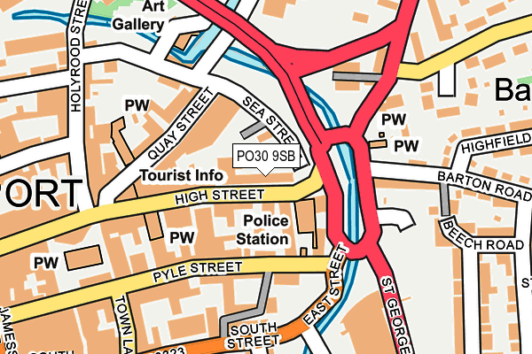
PO30 9SB is located in the Newport Central electoral ward, within the unitary authority of Isle of Wight and the English Parliamentary constituency of Isle of Wight. The Sub Integrated Care Board (ICB) Location is NHS Hampshire and Isle of Wight ICB - D9Y0V and the police force is Hampshire. This postcode has been in use since February 2014.


GetTheData
Source: OS OpenMap – Local (Ordnance Survey)
Source: OS VectorMap District (Ordnance Survey)
Licence: Open Government Licence (requires attribution)
| Easting | 450180 |
| Northing | 89236 |
| Latitude | 50.700609 |
| Longitude | -1.290819 |
GetTheData
Source: Open Postcode Geo
Licence: Open Government Licence
| Country | England |
| Postcode District | PO30 |
| ➜ PO30 open data dashboard ➜ See where PO30 is on a map ➜ Where is Newport? | |
GetTheData
Source: Land Registry Price Paid Data
Licence: Open Government Licence
Elevation or altitude of PO30 9SB as distance above sea level:
| Metres | Feet | |
|---|---|---|
| Elevation | 0m | 0ft |
Elevation is measured from the approximate centre of the postcode, to the nearest point on an OS contour line from OS Terrain 50, which has contour spacing of ten vertical metres.
➜ How high above sea level am I? Find the elevation of your current position using your device's GPS.
GetTheData
Source: Open Postcode Elevation
Licence: Open Government Licence
| Ward | Newport Central |
| Constituency | Isle Of Wight |
GetTheData
Source: ONS Postcode Database
Licence: Open Government Licence
| January 2024 | Robbery | On or near Sea Street | 137m |
| January 2024 | Violence and sexual offences | On or near Sea Street | 137m |
| January 2024 | Theft from the person | On or near Parking Area | 417m |
| ➜ Get more crime data in our Crime section | |||
GetTheData
Source: data.police.uk
Licence: Open Government Licence
| Old Police Station (Snooks Hill) | Newport | 256m |
| Old Police Station (Snooks Hill) | Newport | 263m |
| Barton Road | Barton | 297m |
| Broadlands House (Staplers Road) | Staplers | 353m |
| School Lane | Barton | 389m |
GetTheData
Source: NaPTAN
Licence: Open Government Licence
GetTheData
Source: ONS Postcode Database
Licence: Open Government Licence


➜ Get more ratings from the Food Standards Agency
GetTheData
Source: Food Standards Agency
Licence: FSA terms & conditions
| Last Collection | |||
|---|---|---|---|
| Location | Mon-Fri | Sat | Distance |
| Police Station | 17:30 | 12:30 | 52m |
| Town Hall | 17:30 | 12:30 | 149m |
| Town Hall | 17:30 | 12:30 | 151m |
GetTheData
Source: Dracos
Licence: Creative Commons Attribution-ShareAlike
| Facility | Distance |
|---|---|
| Isle Be Fit Holyrood Street, Newport Health and Fitness Gym | 213m |
| The Gym Group (Isle Of Wight) Coppins Bridge Leisure Park, Newport Health and Fitness Gym | 246m |
| Fit2relax Gym (Closed) Bowling Green Lane, Newport Health and Fitness Gym | 396m |
GetTheData
Source: Active Places
Licence: Open Government Licence
| School | Phase of Education | Distance |
|---|---|---|
| Barton Primary School Furrlongs, Newport, PO30 2AX | Primary | 410m |
| Medina House School School Lane, Newport Isle of Wight, PO30 2HS | Not applicable | 448m |
| The Isle of Wight College Medina Way, Newport, PO30 5TA | 16 plus | 732m |
GetTheData
Source: Edubase
Licence: Open Government Licence
| Risk of PO30 9SB flooding from rivers and sea | Medium |
| ➜ PO30 9SB flood map | |
GetTheData
Source: Open Flood Risk by Postcode
Licence: Open Government Licence
The below table lists the International Territorial Level (ITL) codes (formerly Nomenclature of Territorial Units for Statistics (NUTS) codes) and Local Administrative Units (LAU) codes for PO30 9SB:
| ITL 1 Code | Name |
|---|---|
| TLJ | South East (England) |
| ITL 2 Code | Name |
| TLJ3 | Hampshire and Isle of Wight |
| ITL 3 Code | Name |
| TLJ34 | Isle of Wight |
| LAU 1 Code | Name |
| E06000046 | Isle of Wight |
GetTheData
Source: ONS Postcode Directory
Licence: Open Government Licence
The below table lists the Census Output Area (OA), Lower Layer Super Output Area (LSOA), and Middle Layer Super Output Area (MSOA) for PO30 9SB:
| Code | Name | |
|---|---|---|
| OA | E00087492 | |
| LSOA | E01017326 | Isle of Wight 009C |
| MSOA | E02003589 | Isle of Wight 009 |
GetTheData
Source: ONS Postcode Directory
Licence: Open Government Licence
| PO30 1AG | Pyle Street | 75m |
| PO30 1SS | High Street | 84m |
| PO30 1JN | East Street | 87m |
| PO30 1AP | Pyle Street | 95m |
| PO30 1TY | High Street | 109m |
| PO30 1JW | Pyle Street | 120m |
| PO30 5BA | Quay Street | 134m |
| PO30 2BX | Coppins Bridge | 152m |
| PO30 5BW | Sea Street | 159m |
| PO30 2HH | Barton Road | 159m |
GetTheData
Source: Open Postcode Geo; Land Registry Price Paid Data
Licence: Open Government Licence