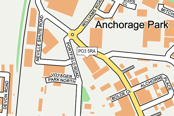
PO3 5RA is located in the Copnor electoral ward, within the unitary authority of Portsmouth and the English Parliamentary constituency of Portsmouth North. The Sub Integrated Care Board (ICB) Location is NHS Hampshire and Isle of Wight ICB - 10R and the police force is Hampshire. This postcode has been in use since May 2002.


GetTheData
Source: OS OpenMap – Local (Ordnance Survey)
Source: OS VectorMap District (Ordnance Survey)
Licence: Open Government Licence (requires attribution)
| Easting | 466539 |
| Northing | 103245 |
| Latitude | 50.824930 |
| Longitude | -1.056678 |
GetTheData
Source: Open Postcode Geo
Licence: Open Government Licence
| Country | England |
| Postcode District | PO3 |
| ➜ PO3 open data dashboard ➜ See where PO3 is on a map ➜ Where is Portsmouth? | |
GetTheData
Source: Land Registry Price Paid Data
Licence: Open Government Licence
Elevation or altitude of PO3 5RA as distance above sea level:
| Metres | Feet | |
|---|---|---|
| Elevation | 0m | 0ft |
Elevation is measured from the approximate centre of the postcode, to the nearest point on an OS contour line from OS Terrain 50, which has contour spacing of ten vertical metres.
➜ How high above sea level am I? Find the elevation of your current position using your device's GPS.
GetTheData
Source: Open Postcode Elevation
Licence: Open Government Licence
| Ward | Copnor |
| Constituency | Portsmouth North |
GetTheData
Source: ONS Postcode Database
Licence: Open Government Licence
| October 2023 | Vehicle crime | On or near Corby Crescent | 471m |
| May 2023 | Public order | On or near Corby Crescent | 471m |
| April 2023 | Violence and sexual offences | On or near Corby Crescent | 471m |
| ➜ Get more crime data in our Crime section | |||
GetTheData
Source: data.police.uk
Licence: Open Government Licence
| Williams Road (Anchorage Road) | Anchorage Park | 311m |
| Williams Road (Anchorage Road) | Anchorage Park | 324m |
| Sywell Crescent | Anchorage Park | 463m |
| Sywell Crescent | Anchorage Park | 538m |
| Norway Road | Hilsea | 582m |
| Hilsea Station | 0.4km |
| Cosham Station | 2km |
| Fratton Station | 3.4km |
GetTheData
Source: NaPTAN
Licence: Open Government Licence
GetTheData
Source: ONS Postcode Database
Licence: Open Government Licence

➜ Get more ratings from the Food Standards Agency
GetTheData
Source: Food Standards Agency
Licence: FSA terms & conditions
| Last Collection | |||
|---|---|---|---|
| Location | Mon-Fri | Sat | Distance |
| The Nelson Centre | 18:30 | 11:30 | 279m |
| Airport | 18:30 | 11:30 | 293m |
| Devon Road | 16:45 | 11:30 | 352m |
GetTheData
Source: Dracos
Licence: Creative Commons Attribution-ShareAlike
| Facility | Distance |
|---|---|
| Pompey Health And Fitness Copnor Road, Portsmouth Swimming Pool, Health and Fitness Gym, Studio, Squash Courts, Outdoor Tennis Courts | 437m |
| Playfootball (Portsmouth) Copnor Road, Portsmouth Artificial Grass Pitch | 441m |
| Rugby Camp Norway Road, Portsmouth Grass Pitches | 462m |
GetTheData
Source: Active Places
Licence: Open Government Licence
| School | Phase of Education | Distance |
|---|---|---|
| Admiral Lord Nelson School Dundas Lane, Portsmouth, PO3 5XT | Secondary | 863m |
| Cliffdale Primary Academy Battenburg Avenue, North End, Portsmouth, PO2 0SN | Not applicable | 908m |
| Gatcombe Park Primary School St Barbara Way, Hilsea, Portsmouth, PO2 0UR | Primary | 919m |
GetTheData
Source: Edubase
Licence: Open Government Licence
| Risk of PO3 5RA flooding from rivers and sea | High |
| ➜ PO3 5RA flood map | |
GetTheData
Source: Open Flood Risk by Postcode
Licence: Open Government Licence
The below table lists the International Territorial Level (ITL) codes (formerly Nomenclature of Territorial Units for Statistics (NUTS) codes) and Local Administrative Units (LAU) codes for PO3 5RA:
| ITL 1 Code | Name |
|---|---|
| TLJ | South East (England) |
| ITL 2 Code | Name |
| TLJ3 | Hampshire and Isle of Wight |
| ITL 3 Code | Name |
| TLJ31 | Portsmouth |
| LAU 1 Code | Name |
| E06000044 | Portsmouth |
GetTheData
Source: ONS Postcode Directory
Licence: Open Government Licence
The below table lists the Census Output Area (OA), Lower Layer Super Output Area (LSOA), and Middle Layer Super Output Area (MSOA) for PO3 5RA:
| Code | Name | |
|---|---|---|
| OA | E00086065 | |
| LSOA | E01017048 | Portsmouth 008D |
| MSOA | E02003531 | Portsmouth 008 |
GetTheData
Source: ONS Postcode Directory
Licence: Open Government Licence
| PO3 5FX | Voyager Park North | 137m |
| PO3 5QQ | Highgrove Industrial Park | 191m |
| PO3 5ET | Devon Road | 286m |
| PO3 5ES | Wesley Grove | 351m |
| PO3 5XS | Sutton Close | 352m |
| PO3 5UT | Sutton Close | 365m |
| PO3 5UW | Latimer Court | 367m |
| PO3 5EX | Lovett Road | 374m |
| PO3 5FN | Voyager Park | 379m |
| PO3 5YB | Sywell Crescent | 412m |
GetTheData
Source: Open Postcode Geo; Land Registry Price Paid Data
Licence: Open Government Licence