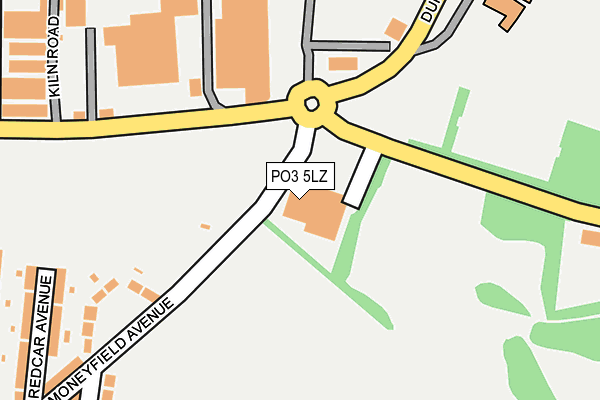
PO3 5LZ is located in the Baffins electoral ward, within the unitary authority of Portsmouth and the English Parliamentary constituency of Portsmouth North. The Sub Integrated Care Board (ICB) Location is NHS Hampshire and Isle of Wight ICB - 10R and the police force is Hampshire. This postcode has been in use since January 1980.


GetTheData
Source: OS OpenMap – Local (Ordnance Survey)
Source: OS VectorMap District (Ordnance Survey)
Licence: Open Government Licence (requires attribution)
| Easting | 466695 |
| Northing | 102236 |
| Latitude | 50.815830 |
| Longitude | -1.054632 |
GetTheData
Source: Open Postcode Geo
Licence: Open Government Licence
| Country | England |
| Postcode District | PO3 |
| ➜ PO3 open data dashboard ➜ See where PO3 is on a map ➜ Where is Portsmouth? | |
GetTheData
Source: Land Registry Price Paid Data
Licence: Open Government Licence
Elevation or altitude of PO3 5LZ as distance above sea level:
| Metres | Feet | |
|---|---|---|
| Elevation | 0m | 0ft |
Elevation is measured from the approximate centre of the postcode, to the nearest point on an OS contour line from OS Terrain 50, which has contour spacing of ten vertical metres.
➜ How high above sea level am I? Find the elevation of your current position using your device's GPS.
GetTheData
Source: Open Postcode Elevation
Licence: Open Government Licence
| Ward | Baffins |
| Constituency | Portsmouth North |
GetTheData
Source: ONS Postcode Database
Licence: Open Government Licence
| June 2022 | Shoplifting | On or near Moneyfield Avenue | 227m |
| June 2022 | Vehicle crime | On or near Redcar Avenue | 298m |
| June 2022 | Criminal damage and arson | On or near Kiln Road | 299m |
| ➜ Get more crime data in our Crime section | |||
GetTheData
Source: data.police.uk
Licence: Open Government Licence
| Copythorn Road (Copnor Road) | Copnor | 700m |
| Copythorn Road (Copnor Road) | Copnor | 708m |
| Chichester Road (Copnor Road) | Copnor | 733m |
| Chichester Road (Copnor Road) | Copnor | 765m |
| Highgrove Road (Tangier Road) | Baffins | 786m |
| Hilsea Station | 1.4km |
| Fratton Station | 2.6km |
| Cosham Station | 3km |
GetTheData
Source: NaPTAN
Licence: Open Government Licence
GetTheData
Source: ONS Postcode Database
Licence: Open Government Licence


➜ Get more ratings from the Food Standards Agency
GetTheData
Source: Food Standards Agency
Licence: FSA terms & conditions
| Last Collection | |||
|---|---|---|---|
| Location | Mon-Fri | Sat | Distance |
| Teignmouth Road | 16:45 | 11:45 | 483m |
| Burrfields Road | 17:30 | 11:30 | 582m |
| Quartermaine Road | 18:30 | 639m | |
GetTheData
Source: Dracos
Licence: Creative Commons Attribution-ShareAlike
| Facility | Distance |
|---|---|
| Admiral Lord Nelson School Sports Centre Dundas Lane, Portsmouth Sports Hall, Artificial Grass Pitch, Studio, Health and Fitness Gym, Outdoor Tennis Courts | 351m |
| Moneyfields Sports & Social Club Moneyfield Avenue, Portsmouth Grass Pitches, Artificial Grass Pitch, Health and Fitness Gym | 446m |
| Portsmouth Golf Centre Burrfields Road, Portsmouth Golf | 703m |
GetTheData
Source: Active Places
Licence: Open Government Licence
| School | Phase of Education | Distance |
|---|---|---|
| Admiral Lord Nelson School Dundas Lane, Portsmouth, PO3 5XT | Secondary | 320m |
| Copnor Primary School Copnor Road, Portsmouth, PO3 5BZ | Primary | 682m |
| Westover Primary School Westover Road, Portsmouth, PO3 6NS | Primary | 691m |
GetTheData
Source: Edubase
Licence: Open Government Licence
| Risk of PO3 5LZ flooding from rivers and sea | Medium |
| ➜ PO3 5LZ flood map | |
GetTheData
Source: Open Flood Risk by Postcode
Licence: Open Government Licence
The below table lists the International Territorial Level (ITL) codes (formerly Nomenclature of Territorial Units for Statistics (NUTS) codes) and Local Administrative Units (LAU) codes for PO3 5LZ:
| ITL 1 Code | Name |
|---|---|
| TLJ | South East (England) |
| ITL 2 Code | Name |
| TLJ3 | Hampshire and Isle of Wight |
| ITL 3 Code | Name |
| TLJ31 | Portsmouth |
| LAU 1 Code | Name |
| E06000044 | Portsmouth |
GetTheData
Source: ONS Postcode Directory
Licence: Open Government Licence
The below table lists the Census Output Area (OA), Lower Layer Super Output Area (LSOA), and Middle Layer Super Output Area (MSOA) for PO3 5LZ:
| Code | Name | |
|---|---|---|
| OA | E00085934 | |
| LSOA | E01017014 | Portsmouth 008A |
| MSOA | E02003531 | Portsmouth 008 |
GetTheData
Source: ONS Postcode Directory
Licence: Open Government Licence
| PO3 6LB | Moneyfield Avenue | 255m |
| PO3 6LE | Redcar Avenue | 300m |
| PO3 5NH | Claybank Road | 326m |
| PO3 6LG | Seaton Avenue | 343m |
| PO3 6LD | Salcombe Avenue | 363m |
| PO3 5LL | The Approach | 364m |
| PO3 6LA | Moneyfield Avenue | 399m |
| PO3 6LJ | Sidmouth Avenue | 402m |
| PO3 5SX | O Jays Industrial Park | 431m |
| PO3 6LH | Teignmouth Road | 459m |
GetTheData
Source: Open Postcode Geo; Land Registry Price Paid Data
Licence: Open Government Licence