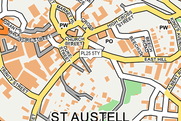
PL25 5TY is located in the St Austell Central & Gover electoral ward, within the unitary authority of Cornwall and the English Parliamentary constituency of St Austell and Newquay. The Sub Integrated Care Board (ICB) Location is NHS Cornwall and the Isles of Scilly ICB - 11N and the police force is Devon & Cornwall. This postcode has been in use since December 1996.


GetTheData
Source: OS OpenMap – Local (Ordnance Survey)
Source: OS VectorMap District (Ordnance Survey)
Licence: Open Government Licence (requires attribution)
| Easting | 201482 |
| Northing | 52361 |
| Latitude | 50.337639 |
| Longitude | -4.791062 |
GetTheData
Source: Open Postcode Geo
Licence: Open Government Licence
| Country | England |
| Postcode District | PL25 |
| ➜ PL25 open data dashboard ➜ See where PL25 is on a map ➜ Where is St Austell? | |
GetTheData
Source: Land Registry Price Paid Data
Licence: Open Government Licence
Elevation or altitude of PL25 5TY as distance above sea level:
| Metres | Feet | |
|---|---|---|
| Elevation | 60m | 197ft |
Elevation is measured from the approximate centre of the postcode, to the nearest point on an OS contour line from OS Terrain 50, which has contour spacing of ten vertical metres.
➜ How high above sea level am I? Find the elevation of your current position using your device's GPS.
GetTheData
Source: Open Postcode Elevation
Licence: Open Government Licence
| Ward | St Austell Central & Gover |
| Constituency | St Austell And Newquay |
GetTheData
Source: ONS Postcode Database
Licence: Open Government Licence
| July 2022 | Anti-social behaviour | On or near Cross Lane | 113m |
| June 2022 | Anti-social behaviour | On or near Parking Area | 34m |
| June 2022 | Public order | On or near Duke Street | 92m |
| ➜ Get more crime data in our Crime section | |||
GetTheData
Source: data.police.uk
Licence: Open Government Licence
| Duke Street | St Austell | 89m |
| South Street | St Austell | 97m |
| South Street | St Austell | 115m |
| White River Cinema | St Austell | 294m |
| Kings Avenue (King's Avenue) | St Austell | 299m |
| St Austell Station | 0.2km |
GetTheData
Source: NaPTAN
Licence: Open Government Licence
GetTheData
Source: ONS Postcode Database
Licence: Open Government Licence


➜ Get more ratings from the Food Standards Agency
GetTheData
Source: Food Standards Agency
Licence: FSA terms & conditions
| Last Collection | |||
|---|---|---|---|
| Location | Mon-Fri | Sat | Distance |
| Fore Street | 16:00 | 12:00 | 159m |
| Railway Station | 17:30 | 09:30 | 245m |
| Tregonney Hill | 11:15 | 10:30 | 282m |
GetTheData
Source: Dracos
Licence: Creative Commons Attribution-ShareAlike
| Facility | Distance |
|---|---|
| Snap Fitness (St Austell) Aylmer Square, Aylmer Square, St Austell Health and Fitness Gym | 189m |
| St Austell College (Closed) Trevarthian Road, St. Austell Health and Fitness Gym | 492m |
| Poltair Park Poltair Road, St Austell Grass Pitches, Outdoor Tennis Courts | 615m |
GetTheData
Source: Active Places
Licence: Open Government Licence
| School | Phase of Education | Distance |
|---|---|---|
| Restormel Academy Great Eastern & Great Western, The Sidings, Brunel Business Park, St Austell, PL25 4TJ | Not applicable | 722m |
| Poltair School Trevarthian Road, St Austell, PL25 4BZ | Secondary | 753m |
| Pondhu Primary School Penwinnick Road, St. Austell, PL25 5DS | Primary | 779m |
GetTheData
Source: Edubase
Licence: Open Government Licence
The below table lists the International Territorial Level (ITL) codes (formerly Nomenclature of Territorial Units for Statistics (NUTS) codes) and Local Administrative Units (LAU) codes for PL25 5TY:
| ITL 1 Code | Name |
|---|---|
| TLK | South West (England) |
| ITL 2 Code | Name |
| TLK3 | Cornwall and Isles of Scilly |
| ITL 3 Code | Name |
| TLK30 | Cornwall and Isles of Scilly |
| LAU 1 Code | Name |
| E06000052 | Cornwall |
GetTheData
Source: ONS Postcode Directory
Licence: Open Government Licence
The below table lists the Census Output Area (OA), Lower Layer Super Output Area (LSOA), and Middle Layer Super Output Area (MSOA) for PL25 5TY:
| Code | Name | |
|---|---|---|
| OA | E00096215 | |
| LSOA | E01019041 | Cornwall 039B |
| MSOA | E02003963 | Cornwall 039 |
GetTheData
Source: ONS Postcode Directory
Licence: Open Government Licence
| PL25 4TW | East Hill | 49m |
| PL25 5BH | South Street | 53m |
| PL25 4AT | Church Street | 76m |
| PL25 5PQ | Duke Street | 80m |
| PL25 5DQ | South Street | 95m |
| PL25 4AB | High Cross Street | 104m |
| PL25 5BJ | South Street | 108m |
| PL25 5BL | Court Gardens | 108m |
| PL25 5PE | Victoria Place | 112m |
| PL25 4SZ | Eastbourne Road | 112m |
GetTheData
Source: Open Postcode Geo; Land Registry Price Paid Data
Licence: Open Government Licence