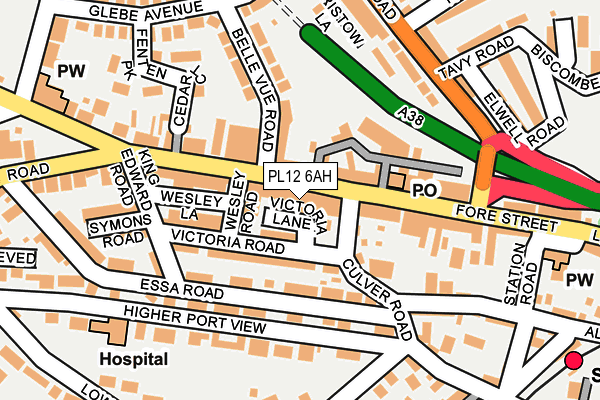
PL12 6AH is located in the Saltash Essa electoral ward, within the unitary authority of Cornwall and the English Parliamentary constituency of South East Cornwall. The Sub Integrated Care Board (ICB) Location is NHS Cornwall and the Isles of Scilly ICB - 11N and the police force is Devon & Cornwall. This postcode has been in use since January 1980.


GetTheData
Source: OS OpenMap – Local (Ordnance Survey)
Source: OS VectorMap District (Ordnance Survey)
Licence: Open Government Licence (requires attribution)
| Easting | 242854 |
| Northing | 58870 |
| Latitude | 50.408632 |
| Longitude | -4.212916 |
GetTheData
Source: Open Postcode Geo
Licence: Open Government Licence
| Country | England |
| Postcode District | PL12 |
| ➜ PL12 open data dashboard ➜ See where PL12 is on a map ➜ Where is Saltash? | |
GetTheData
Source: Land Registry Price Paid Data
Licence: Open Government Licence
Elevation or altitude of PL12 6AH as distance above sea level:
| Metres | Feet | |
|---|---|---|
| Elevation | 50m | 164ft |
Elevation is measured from the approximate centre of the postcode, to the nearest point on an OS contour line from OS Terrain 50, which has contour spacing of ten vertical metres.
➜ How high above sea level am I? Find the elevation of your current position using your device's GPS.
GetTheData
Source: Open Postcode Elevation
Licence: Open Government Licence
| Ward | Saltash Essa |
| Constituency | South East Cornwall |
GetTheData
Source: ONS Postcode Database
Licence: Open Government Licence
| July 2022 | Other theft | On or near Fenten Park | 219m |
| July 2022 | Anti-social behaviour | On or near Trelawney Road | 492m |
| June 2022 | Anti-social behaviour | On or near Victoria Lane | 24m |
| ➜ Get more crime data in our Crime section | |||
GetTheData
Source: data.police.uk
Licence: Open Government Licence
| Fore Street Bottom (Fore Street) | Saltash | 117m |
| Fore Street Top (Fore Street) | Saltash | 133m |
| Fore Street Top (Fore Street) | Saltash | 141m |
| Fore Street Bottom (Fore Street) | Saltash | 147m |
| North Road (Tavy Road) | Saltash | 180m |
| Saltash Station | 0.3km |
| St Budeaux Victoria Road Station | 2km |
| St Budeaux Ferry Road Station | 2km |
GetTheData
Source: NaPTAN
Licence: Open Government Licence
GetTheData
Source: ONS Postcode Database
Licence: Open Government Licence


➜ Get more ratings from the Food Standards Agency
GetTheData
Source: Food Standards Agency
Licence: FSA terms & conditions
| Last Collection | |||
|---|---|---|---|
| Location | Mon-Fri | Sat | Distance |
| Saltash Delivery Office | 17:30 | 12:30 | 49m |
| Saltash Post Office | 17:15 | 12:15 | 91m |
| North Road | 17:00 | 12:15 | 208m |
GetTheData
Source: Dracos
Licence: Creative Commons Attribution-ShareAlike
| Facility | Distance |
|---|---|
| Brunel Primary And Nursery Academy Callington Road, Saltash Grass Pitches | 504m |
| Saltash Leisure Centre Plougastel Drive, Saltash Swimming Pool, Health and Fitness Gym, Studio | 650m |
| Saltmill Park Salt Mill, Saltash Artificial Grass Pitch | 725m |
GetTheData
Source: Active Places
Licence: Open Government Licence
| School | Phase of Education | Distance |
|---|---|---|
| Brunel Primary & Nursery Academy Callington Road, Saltash, PL12 6DX | Primary | 504m |
| Bishop Cornish CofE VA Primary School Lynher Drive, Saltash, PL12 4PA | Primary | 737m |
| St Stephens (Saltash) Community Primary School Long Park Road, Saltash, PL12 4AQ | Primary | 833m |
GetTheData
Source: Edubase
Licence: Open Government Licence
The below table lists the International Territorial Level (ITL) codes (formerly Nomenclature of Territorial Units for Statistics (NUTS) codes) and Local Administrative Units (LAU) codes for PL12 6AH:
| ITL 1 Code | Name |
|---|---|
| TLK | South West (England) |
| ITL 2 Code | Name |
| TLK3 | Cornwall and Isles of Scilly |
| ITL 3 Code | Name |
| TLK30 | Cornwall and Isles of Scilly |
| LAU 1 Code | Name |
| E06000052 | Cornwall |
GetTheData
Source: ONS Postcode Directory
Licence: Open Government Licence
The below table lists the Census Output Area (OA), Lower Layer Super Output Area (LSOA), and Middle Layer Super Output Area (MSOA) for PL12 6AH:
| Code | Name | |
|---|---|---|
| OA | E00094876 | |
| LSOA | E01018793 | Cornwall 026D |
| MSOA | E02003900 | Cornwall 026 |
GetTheData
Source: ONS Postcode Directory
Licence: Open Government Licence
| PL12 6AE | Fore Street | 9m |
| PL12 6TX | Victoria Lane | 19m |
| PL12 6JW | Fore Street | 36m |
| PL12 4DL | Victoria Road | 64m |
| PL12 4DW | Culver Road | 70m |
| PL12 4ED | Essa Road | 89m |
| PL12 6JL | Fore Street | 97m |
| PL12 4DN | Victoria Road | 102m |
| PL12 6TT | Wesley Lane | 105m |
| PL12 4DP | Culver Road | 107m |
GetTheData
Source: Open Postcode Geo; Land Registry Price Paid Data
Licence: Open Government Licence