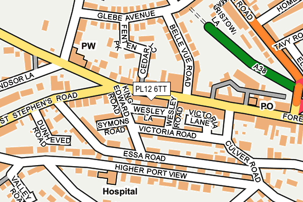
PL12 6TT lies on Wesley Lane in Saltash. PL12 6TT is located in the Saltash Essa electoral ward, within the unitary authority of Cornwall and the English Parliamentary constituency of South East Cornwall. The Sub Integrated Care Board (ICB) Location is NHS Cornwall and the Isles of Scilly ICB - 11N and the police force is Devon & Cornwall. This postcode has been in use since March 1988.


GetTheData
Source: OS OpenMap – Local (Ordnance Survey)
Source: OS VectorMap District (Ordnance Survey)
Licence: Open Government Licence (requires attribution)
| Easting | 242750 |
| Northing | 58887 |
| Latitude | 50.408743 |
| Longitude | -4.214416 |
GetTheData
Source: Open Postcode Geo
Licence: Open Government Licence
| Street | Wesley Lane |
| Town/City | Saltash |
| Country | England |
| Postcode District | PL12 |
➜ See where PL12 is on a map ➜ Where is Saltash? | |
GetTheData
Source: Land Registry Price Paid Data
Licence: Open Government Licence
Elevation or altitude of PL12 6TT as distance above sea level:
| Metres | Feet | |
|---|---|---|
| Elevation | 60m | 197ft |
Elevation is measured from the approximate centre of the postcode, to the nearest point on an OS contour line from OS Terrain 50, which has contour spacing of ten vertical metres.
➜ How high above sea level am I? Find the elevation of your current position using your device's GPS.
GetTheData
Source: Open Postcode Elevation
Licence: Open Government Licence
| Ward | Saltash Essa |
| Constituency | South East Cornwall |
GetTheData
Source: ONS Postcode Database
Licence: Open Government Licence
| Fore Street Top (Fore Street) | Saltash | 31m |
| Fore Street Top (Fore Street) | Saltash | 41m |
| Glebe Avenue | Saltash | 194m |
| Glebe Avenue | Saltash | 209m |
| Fore Street Bottom (Fore Street) | Saltash | 222m |
| Saltash Station | 0.4km |
| St Budeaux Victoria Road Station | 2.1km |
| St Budeaux Ferry Road Station | 2.1km |
GetTheData
Source: NaPTAN
Licence: Open Government Licence
| Percentage of properties with Next Generation Access | 100.0% |
| Percentage of properties with Superfast Broadband | 100.0% |
| Percentage of properties with Ultrafast Broadband | 100.0% |
| Percentage of properties with Full Fibre Broadband | 0.0% |
Superfast Broadband is between 30Mbps and 300Mbps
Ultrafast Broadband is > 300Mbps
| Percentage of properties unable to receive 2Mbps | 0.0% |
| Percentage of properties unable to receive 5Mbps | 0.0% |
| Percentage of properties unable to receive 10Mbps | 0.0% |
| Percentage of properties unable to receive 30Mbps | 0.0% |
GetTheData
Source: Ofcom
Licence: Ofcom Terms of Use (requires attribution)
GetTheData
Source: ONS Postcode Database
Licence: Open Government Licence


➜ Get more ratings from the Food Standards Agency
GetTheData
Source: Food Standards Agency
Licence: FSA terms & conditions
| Last Collection | |||
|---|---|---|---|
| Location | Mon-Fri | Sat | Distance |
| Saltash Delivery Office | 17:30 | 12:30 | 59m |
| Saltash Post Office | 17:15 | 12:15 | 195m |
| Glebe Avenue | 17:00 | 12:15 | 203m |
GetTheData
Source: Dracos
Licence: Creative Commons Attribution-ShareAlike
The below table lists the International Territorial Level (ITL) codes (formerly Nomenclature of Territorial Units for Statistics (NUTS) codes) and Local Administrative Units (LAU) codes for PL12 6TT:
| ITL 1 Code | Name |
|---|---|
| TLK | South West (England) |
| ITL 2 Code | Name |
| TLK3 | Cornwall and Isles of Scilly |
| ITL 3 Code | Name |
| TLK30 | Cornwall and Isles of Scilly |
| LAU 1 Code | Name |
| E06000052 | Cornwall |
GetTheData
Source: ONS Postcode Directory
Licence: Open Government Licence
The below table lists the Census Output Area (OA), Lower Layer Super Output Area (LSOA), and Middle Layer Super Output Area (MSOA) for PL12 6TT:
| Code | Name | |
|---|---|---|
| OA | E00094876 | |
| LSOA | E01018793 | Cornwall 026D |
| MSOA | E02003900 | Cornwall 026 |
GetTheData
Source: ONS Postcode Directory
Licence: Open Government Licence
| PL12 6AB | Fore Street | 14m |
| PL12 6JR | Fore Street | 37m |
| PL12 4DN | Victoria Road | 42m |
| PL12 6JY | Fore Street | 59m |
| PL12 6FA | King Edward Road | 61m |
| PL12 4EG | Symons Road | 85m |
| PL12 4EQ | King Edward Road | 93m |
| PL12 6JS | Fore Street | 94m |
| PL12 6TX | Victoria Lane | 96m |
| PL12 6DQ | 102m |
GetTheData
Source: Open Postcode Geo; Land Registry Price Paid Data
Licence: Open Government Licence