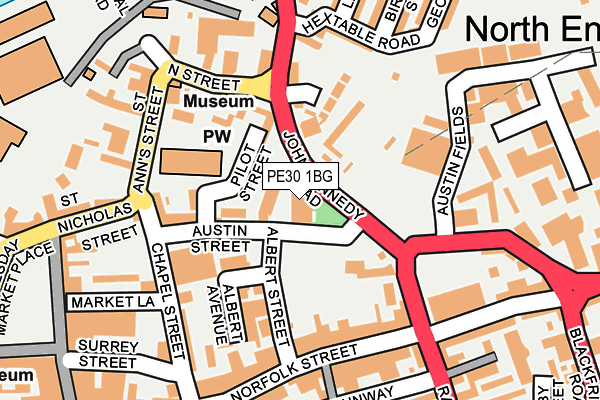
PE30 1BG is located in the St. Margaret's with St. Nicholas electoral ward, within the local authority district of King's Lynn and West Norfolk and the English Parliamentary constituency of North West Norfolk. The Sub Integrated Care Board (ICB) Location is NHS Norfolk and Waveney ICB - 26A and the police force is Norfolk. This postcode has been in use since November 2009.


GetTheData
Source: OS OpenMap – Local (Ordnance Survey)
Source: OS VectorMap District (Ordnance Survey)
Licence: Open Government Licence (requires attribution)
| Easting | 561963 |
| Northing | 320417 |
| Latitude | 52.757086 |
| Longitude | 0.398611 |
GetTheData
Source: Open Postcode Geo
Licence: Open Government Licence
| Country | England |
| Postcode District | PE30 |
| ➜ PE30 open data dashboard ➜ See where PE30 is on a map ➜ Where is King's Lynn? | |
GetTheData
Source: Land Registry Price Paid Data
Licence: Open Government Licence
Elevation or altitude of PE30 1BG as distance above sea level:
| Metres | Feet | |
|---|---|---|
| Elevation | 0m | 0ft |
Elevation is measured from the approximate centre of the postcode, to the nearest point on an OS contour line from OS Terrain 50, which has contour spacing of ten vertical metres.
➜ How high above sea level am I? Find the elevation of your current position using your device's GPS.
GetTheData
Source: Open Postcode Elevation
Licence: Open Government Licence
| Ward | St. Margaret's With St. Nicholas |
| Constituency | North West Norfolk |
GetTheData
Source: ONS Postcode Database
Licence: Open Government Licence
| January 2024 | Shoplifting | On or near Parking Area | 265m |
| January 2024 | Shoplifting | On or near Parking Area | 265m |
| January 2024 | Anti-social behaviour | On or near Blackfriars Road | 406m |
| ➜ Get more crime data in our Crime section | |||
GetTheData
Source: data.police.uk
Licence: Open Government Licence
| Austin Fields (John Kennedy Road) | King's Lynn | 24m |
| Austin Fields (John Kennedy Road) | King's Lynn | 42m |
| Burkitt Street (Loke Road) | North Lynn | 306m |
| Burkitt Street (Loke Road) | North Lynn | 317m |
| Kettlewell Lane (Littleport Street) | King's Lynn | 352m |
| Kings Lynn Station | 0.5km |
GetTheData
Source: NaPTAN
Licence: Open Government Licence
GetTheData
Source: ONS Postcode Database
Licence: Open Government Licence


➜ Get more ratings from the Food Standards Agency
GetTheData
Source: Food Standards Agency
Licence: FSA terms & conditions
| Last Collection | |||
|---|---|---|---|
| Location | Mon-Fri | Sat | Distance |
| Norfolk Street | 18:30 | 237m | |
| Kings Lynn Bo | 18:30 | 12:45 | 284m |
| Tuesday Market Place | 18:30 | 12:15 | 287m |
GetTheData
Source: Dracos
Licence: Creative Commons Attribution-ShareAlike
| Facility | Distance |
|---|---|
| St James Swimming And Fitness Centre Blackfriars Street, King's Lynn Swimming Pool, Health and Fitness Gym | 472m |
| Tower Health & Beauty Clinic (Closed) Tower Place, King's Lynn Health and Fitness Gym | 616m |
| Pulse8 Health & Fitness (Closed) Tennyson Avenue, King's Lynn Sports Hall, Health and Fitness Gym, Studio, Squash Courts | 664m |
GetTheData
Source: Active Places
Licence: Open Government Licence
| School | Phase of Education | Distance |
|---|---|---|
| Eastgate Academy Littleport Terrace, King's Lynn, PE30 1QA | Primary | 371m |
| King's Lynn Nursery School St James Park, London Road, King's Lynn, PE30 5PT | Nursery | 601m |
| Highgate Infant School Gaywood Road, King's Lynn, PE30 2PS | Primary | 652m |
GetTheData
Source: Edubase
Licence: Open Government Licence
| Risk of PE30 1BG flooding from rivers and sea | Medium |
| ➜ PE30 1BG flood map | |
GetTheData
Source: Open Flood Risk by Postcode
Licence: Open Government Licence
The below table lists the International Territorial Level (ITL) codes (formerly Nomenclature of Territorial Units for Statistics (NUTS) codes) and Local Administrative Units (LAU) codes for PE30 1BG:
| ITL 1 Code | Name |
|---|---|
| TLH | East |
| ITL 2 Code | Name |
| TLH1 | East Anglia |
| ITL 3 Code | Name |
| TLH16 | North and West Norfolk |
| LAU 1 Code | Name |
| E07000146 | King's Lynn and West Norfolk |
GetTheData
Source: ONS Postcode Directory
Licence: Open Government Licence
The below table lists the Census Output Area (OA), Lower Layer Super Output Area (LSOA), and Middle Layer Super Output Area (MSOA) for PE30 1BG:
| Code | Name | |
|---|---|---|
| OA | E00135695 | |
| LSOA | E01026698 | King's Lynn and West Norfolk 011A |
| MSOA | E02005561 | King's Lynn and West Norfolk 011 |
GetTheData
Source: ONS Postcode Directory
Licence: Open Government Licence
| PE30 1BF | Austin Street | 33m |
| PE30 1QL | Pilot Street | 67m |
| PE30 1DZ | Austin Street | 78m |
| PE30 1QJ | Chapel Lane | 104m |
| PE30 1ED | Albert Street | 119m |
| PE30 1EE | Albert Avenue | 121m |
| PE30 1NH | St Nicholas Close | 150m |
| PE30 1AQ | Norfolk Street | 153m |
| PE30 1EF | Chapel Street | 158m |
| PE30 1AH | Norfolk Street | 166m |
GetTheData
Source: Open Postcode Geo; Land Registry Price Paid Data
Licence: Open Government Licence