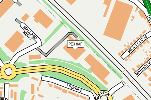
PE3 8AF lies on Mallard Road in Bretton, Peterborough. PE3 8AF is located in the Bretton electoral ward, within the unitary authority of Peterborough and the English Parliamentary constituency of Peterborough. The Sub Integrated Care Board (ICB) Location is NHS Cambridgeshire and Peterborough ICB - 06H and the police force is Cambridgeshire. This postcode has been in use since October 2011.


GetTheData
Source: OS OpenMap – Local (Ordnance Survey)
Source: OS VectorMap District (Ordnance Survey)
Licence: Open Government Licence (requires attribution)
| Easting | 516730 |
| Northing | 302258 |
| Latitude | 52.605574 |
| Longitude | -0.277710 |
GetTheData
Source: Open Postcode Geo
Licence: Open Government Licence
| Street | Mallard Road |
| Locality | Bretton |
| Town/City | Peterborough |
| Country | England |
| Postcode District | PE3 |
| ➜ PE3 open data dashboard ➜ See where PE3 is on a map ➜ Where is Peterborough? | |
GetTheData
Source: Land Registry Price Paid Data
Licence: Open Government Licence
Elevation or altitude of PE3 8AF as distance above sea level:
| Metres | Feet | |
|---|---|---|
| Elevation | 10m | 33ft |
Elevation is measured from the approximate centre of the postcode, to the nearest point on an OS contour line from OS Terrain 50, which has contour spacing of ten vertical metres.
➜ How high above sea level am I? Find the elevation of your current position using your device's GPS.
GetTheData
Source: Open Postcode Elevation
Licence: Open Government Licence
| Ward | Bretton |
| Constituency | Peterborough |
GetTheData
Source: ONS Postcode Database
Licence: Open Government Licence
| June 2022 | Burglary | On or near Marholm Road | 311m |
| June 2022 | Violence and sexual offences | On or near The Mead | 324m |
| June 2022 | Burglary | On or near The Mead | 324m |
| ➜ Mallard Road crime map and outcomes | |||
GetTheData
Source: data.police.uk
Licence: Open Government Licence
| Ice Rink (Bretton Way) | North Bretton | 141m |
| Ice Rink (Bretton Way) | North Bretton | 215m |
| Risby (Bretton Way) | North Bretton | 285m |
| Risby (Bretton Way) | North Bretton | 360m |
| Marholm Road (Lincoln Road) | Walton | 377m |
| Peterborough Station | 3.9km |
GetTheData
Source: NaPTAN
Licence: Open Government Licence
| Median download speed | 52.4Mbps |
| Average download speed | 45.7Mbps |
| Maximum download speed | 73.99Mbps |
| Median upload speed | 8.4Mbps |
| Average upload speed | 9.3Mbps |
| Maximum upload speed | 20.00Mbps |
GetTheData
Source: Ofcom
Licence: Ofcom Terms of Use (requires attribution)
GetTheData
Source: ONS Postcode Database
Licence: Open Government Licence


➜ Get more ratings from the Food Standards Agency
GetTheData
Source: Food Standards Agency
Licence: FSA terms & conditions
| Last Collection | |||
|---|---|---|---|
| Location | Mon-Fri | Sat | Distance |
| Bretoon Way-linkside Bus Stop | 17:45 | 12:15 | 216m |
| Norborn-marholm Road Roundabout | 17:45 | 12:15 | 318m |
| Stirling Way | 17:45 | 12:15 | 342m |
GetTheData
Source: Dracos
Licence: Creative Commons Attribution-ShareAlike
| Facility | Distance |
|---|---|
| Trilogy Health And Fitness (Peterborough) Mallard Road, Peterborough Studio, Health and Fitness Gym | 151m |
| Planet Ice Peterborough Mallard Road, Peterborough Ice Rinks | 249m |
| Lime Academy Watergall Watergall, Bretton, Peterborough Grass Pitches | 577m |
GetTheData
Source: Active Places
Licence: Open Government Licence
| School | Phase of Education | Distance |
|---|---|---|
| Iqra Academy Enterprise Way, Peterborough, PE3 8YQ | Not applicable | 528m |
| Lime Academy Watergall Watergall, Bretton, Peterborough, PE3 8NX | Primary | 611m |
| Queen Katharine Academy Mountsteven Avenue, Walton, Peterborough, PE4 6HX | Secondary | 625m |
GetTheData
Source: Edubase
Licence: Open Government Licence
| Risk of PE3 8AF flooding from rivers and sea | Low |
| ➜ PE3 8AF flood map | |
GetTheData
Source: Open Flood Risk by Postcode
Licence: Open Government Licence
The below table lists the International Territorial Level (ITL) codes (formerly Nomenclature of Territorial Units for Statistics (NUTS) codes) and Local Administrative Units (LAU) codes for PE3 8AF:
| ITL 1 Code | Name |
|---|---|
| TLH | East |
| ITL 2 Code | Name |
| TLH1 | East Anglia |
| ITL 3 Code | Name |
| TLH11 | Peterborough |
| LAU 1 Code | Name |
| E06000031 | Peterborough |
GetTheData
Source: ONS Postcode Directory
Licence: Open Government Licence
The below table lists the Census Output Area (OA), Lower Layer Super Output Area (LSOA), and Middle Layer Super Output Area (MSOA) for PE3 8AF:
| Code | Name | |
|---|---|---|
| OA | E00078856 | |
| LSOA | E01015593 | Peterborough 009A |
| MSOA | E02003245 | Peterborough 009 |
GetTheData
Source: ONS Postcode Directory
Licence: Open Government Licence
| PE3 8AY | Wedgwood Way | 142m |
| PE3 8PA | Linkside | 169m |
| PE3 8YN | Mallard Road | 172m |
| PE3 8PB | Linkside | 219m |
| PE4 6BS | Mead Close | 221m |
| PE4 6WU | Marholm Road | 242m |
| PE3 8NA | Watergall | 253m |
| PE3 8NB | Watergall | 274m |
| PE4 6LA | Lincoln Road | 283m |
| PE3 8NH | Watergall | 313m |
GetTheData
Source: Open Postcode Geo; Land Registry Price Paid Data
Licence: Open Government Licence