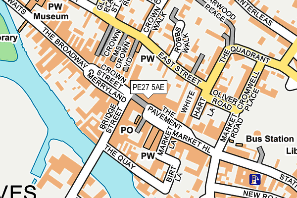
PE27 5AE is located in the St Ives South electoral ward, within the local authority district of Huntingdonshire and the English Parliamentary constituency of Huntingdon. The Sub Integrated Care Board (ICB) Location is NHS Cambridgeshire and Peterborough ICB - 06H and the police force is Cambridgeshire. This postcode has been in use since June 2000.


GetTheData
Source: OS OpenMap – Local (Ordnance Survey)
Source: OS VectorMap District (Ordnance Survey)
Licence: Open Government Licence (requires attribution)
| Easting | 531383 |
| Northing | 271271 |
| Latitude | 52.323817 |
| Longitude | -0.073654 |
GetTheData
Source: Open Postcode Geo
Licence: Open Government Licence
| Country | England |
| Postcode District | PE27 |
| ➜ PE27 open data dashboard ➜ See where PE27 is on a map ➜ Where is St Ives? | |
GetTheData
Source: Land Registry Price Paid Data
Licence: Open Government Licence
Elevation or altitude of PE27 5AE as distance above sea level:
| Metres | Feet | |
|---|---|---|
| Elevation | 10m | 33ft |
Elevation is measured from the approximate centre of the postcode, to the nearest point on an OS contour line from OS Terrain 50, which has contour spacing of ten vertical metres.
➜ How high above sea level am I? Find the elevation of your current position using your device's GPS.
GetTheData
Source: Open Postcode Elevation
Licence: Open Government Licence
| Ward | St Ives South |
| Constituency | Huntingdon |
GetTheData
Source: ONS Postcode Database
Licence: Open Government Licence
| December 2023 | Shoplifting | On or near Parking Area | 301m |
| December 2023 | Violence and sexual offences | On or near Parking Area | 301m |
| December 2023 | Anti-social behaviour | On or near Norris Road | 406m |
| ➜ Get more crime data in our Crime section | |||
GetTheData
Source: data.police.uk
Licence: Open Government Licence
| East Street (The Quadrant) | St Ives | 161m |
| St John's Road (East Street) | St Ives | 176m |
| St John's Road (East Street) | St Ives | 177m |
| The Busway Station Road (Station Road) | St Ives | 201m |
| Norris Road (Broad Leas) | St Ives | 391m |
GetTheData
Source: NaPTAN
Licence: Open Government Licence
GetTheData
Source: ONS Postcode Database
Licence: Open Government Licence


➜ Get more ratings from the Food Standards Agency
GetTheData
Source: Food Standards Agency
Licence: FSA terms & conditions
| Last Collection | |||
|---|---|---|---|
| Location | Mon-Fri | Sat | Distance |
| St Ives Delivery Office | 17:45 | 11:45 | 47m |
| St Ives Post Office | 17:30 | 11:30 | 153m |
| Market Hill | 17:30 | 11:30 | 163m |
GetTheData
Source: Dracos
Licence: Creative Commons Attribution-ShareAlike
| Facility | Distance |
|---|---|
| Optimum Gym (Closed) Market Hill, St. Ives Health and Fitness Gym | 50m |
| Warners Park Park Road, St. Ives Grass Pitches | 455m |
| Westfield Junior School Ramsey Road, St. Ives Swimming Pool, Sports Hall, Grass Pitches | 649m |
GetTheData
Source: Active Places
Licence: Open Government Licence
| School | Phase of Education | Distance |
|---|---|---|
| Eastfield Infant and Nursery School Pig Lane, St Ives, PE27 5QT | Primary | 610m |
| Westfield Junior School Ramsey Road, St Ives, PE27 5RG | Primary | 649m |
| St Ivo Academy High Leys, St Ives, PE27 6RR | Secondary | 1.1km |
GetTheData
Source: Edubase
Licence: Open Government Licence
| Risk of PE27 5AE flooding from rivers and sea | Very Low |
| ➜ PE27 5AE flood map | |
GetTheData
Source: Open Flood Risk by Postcode
Licence: Open Government Licence
The below table lists the International Territorial Level (ITL) codes (formerly Nomenclature of Territorial Units for Statistics (NUTS) codes) and Local Administrative Units (LAU) codes for PE27 5AE:
| ITL 1 Code | Name |
|---|---|
| TLH | East |
| ITL 2 Code | Name |
| TLH1 | East Anglia |
| ITL 3 Code | Name |
| TLH12 | Cambridgeshire CC |
| LAU 1 Code | Name |
| E07000011 | Huntingdonshire |
GetTheData
Source: ONS Postcode Directory
Licence: Open Government Licence
The below table lists the Census Output Area (OA), Lower Layer Super Output Area (LSOA), and Middle Layer Super Output Area (MSOA) for PE27 5AE:
| Code | Name | |
|---|---|---|
| OA | E00091658 | |
| LSOA | E01018168 | Huntingdonshire 013C |
| MSOA | E02003765 | Huntingdonshire 013 |
GetTheData
Source: ONS Postcode Directory
Licence: Open Government Licence
| PE27 5AD | The Pavement | 49m |
| PE27 5DP | St Legers Mews | 67m |
| PE27 5DY | East Street | 70m |
| PE27 5FG | East Street | 70m |
| PE27 5AL | Market Hill | 81m |
| PE27 5EB | Crown Street | 83m |
| PE27 5DF | Vine Court | 86m |
| PE27 5EH | Bridge Street | 87m |
| PE27 5AY | Free Church Passage | 87m |
| PE27 5EG | Bridge Street | 93m |
GetTheData
Source: Open Postcode Geo; Land Registry Price Paid Data
Licence: Open Government Licence