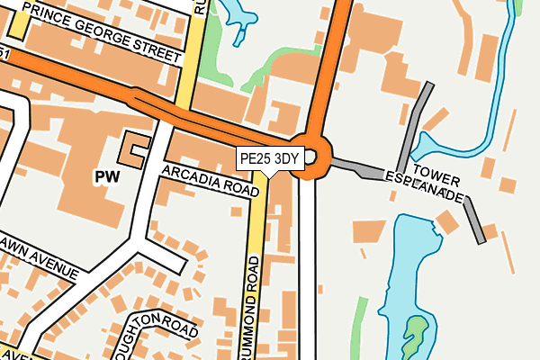
PE25 3DY lies on Sandbeck Arcade in Skegness. PE25 3DY is located in the Scarbrough & Seacroft electoral ward, within the local authority district of East Lindsey and the English Parliamentary constituency of Boston and Skegness. The Sub Integrated Care Board (ICB) Location is NHS Lincolnshire ICB - 71E and the police force is Lincolnshire. This postcode has been in use since January 1980.


GetTheData
Source: OS OpenMap – Local (Ordnance Survey)
Source: OS VectorMap District (Ordnance Survey)
Licence: Open Government Licence (requires attribution)
| Easting | 556824 |
| Northing | 363069 |
| Latitude | 53.141692 |
| Longitude | 0.343149 |
GetTheData
Source: Open Postcode Geo
Licence: Open Government Licence
| Street | Sandbeck Arcade |
| Town/City | Skegness |
| Country | England |
| Postcode District | PE25 |
| ➜ PE25 open data dashboard ➜ See where PE25 is on a map ➜ Where is Skegness? | |
GetTheData
Source: Land Registry Price Paid Data
Licence: Open Government Licence
Elevation or altitude of PE25 3DY as distance above sea level:
| Metres | Feet | |
|---|---|---|
| Elevation | 0m | 0ft |
Elevation is measured from the approximate centre of the postcode, to the nearest point on an OS contour line from OS Terrain 50, which has contour spacing of ten vertical metres.
➜ How high above sea level am I? Find the elevation of your current position using your device's GPS.
GetTheData
Source: Open Postcode Elevation
Licence: Open Government Licence
| Ward | Scarbrough & Seacroft |
| Constituency | Boston And Skegness |
GetTheData
Source: ONS Postcode Database
Licence: Open Government Licence
| January 2024 | Anti-social behaviour | On or near South View Close | 261m |
| January 2024 | Anti-social behaviour | On or near South View Close | 261m |
| January 2024 | Anti-social behaviour | On or near South View Close | 261m |
| ➜ Get more crime data in our Crime section | |||
GetTheData
Source: data.police.uk
Licence: Open Government Licence
| Tower Cinema (Lumley Road) | Skegness | 74m |
| Beresford Avenue (Lumley Road) | Skegness | 87m |
| Embassy Centre (Grand Parade) | Skegness | 106m |
| Drummond Road | Skegness | 144m |
| Embassy Centre (Grand Parade) | Skegness | 145m |
| Skegness Station | 0.6km |
| Havenhouse Station | 5.6km |
GetTheData
Source: NaPTAN
Licence: Open Government Licence
GetTheData
Source: ONS Postcode Database
Licence: Open Government Licence


➜ Get more ratings from the Food Standards Agency
GetTheData
Source: Food Standards Agency
Licence: FSA terms & conditions
| Last Collection | |||
|---|---|---|---|
| Location | Mon-Fri | Sat | Distance |
| Lumley Road-lloyds Bank | 17:30 | 11:45 | 285m |
| South Parade | 17:30 | 11:45 | 293m |
GetTheData
Source: Dracos
Licence: Creative Commons Attribution-ShareAlike
| Facility | Distance |
|---|---|
| Skegness Swimming Pool And Fitness Suite Grand Parade, Skegness Swimming Pool, Health and Fitness Gym | 187m |
| Skegness Cricket Club Lumley Square, Skegness Grass Pitches, Squash Courts | 465m |
| Phoenix Fitness Skegness Victoria Road, Skegness Health and Fitness Gym | 989m |
GetTheData
Source: Active Places
Licence: Open Government Licence
| School | Phase of Education | Distance |
|---|---|---|
| The Richmond School, Skegness Richmond Drive, Skegness, PE25 3SH | Primary | 652m |
| The Richmond School, Skegness Richmond Drive, Skegness, PE25 3SH | Primary | 652m |
| Skegness Infant Academy Cavendish Road, Skegness, PE25 2QU | Primary | 866m |
GetTheData
Source: Edubase
Licence: Open Government Licence
| Risk of PE25 3DY flooding from rivers and sea | Low |
| ➜ PE25 3DY flood map | |
GetTheData
Source: Open Flood Risk by Postcode
Licence: Open Government Licence
The below table lists the International Territorial Level (ITL) codes (formerly Nomenclature of Territorial Units for Statistics (NUTS) codes) and Local Administrative Units (LAU) codes for PE25 3DY:
| ITL 1 Code | Name |
|---|---|
| TLF | East Midlands (England) |
| ITL 2 Code | Name |
| TLF3 | Lincolnshire |
| ITL 3 Code | Name |
| TLF30 | Lincolnshire CC |
| LAU 1 Code | Name |
| E07000137 | East Lindsey |
GetTheData
Source: ONS Postcode Directory
Licence: Open Government Licence
The below table lists the Census Output Area (OA), Lower Layer Super Output Area (LSOA), and Middle Layer Super Output Area (MSOA) for PE25 3DY:
| Code | Name | |
|---|---|---|
| OA | E00132453 | |
| LSOA | E01026093 | East Lindsey 014B |
| MSOA | E02005437 | East Lindsey 014 |
GetTheData
Source: ONS Postcode Directory
Licence: Open Government Licence
| PE25 3HN | Sandbeck Arcade | 17m |
| PE25 3EA | Tower Row | 41m |
| PE25 3NA | Lumley Road | 81m |
| PE25 3JE | Arcadia Crescent | 130m |
| PE25 3JD | Beresford Avenue | 139m |
| PE25 3EB | Drummond Road | 151m |
| PE25 2AD | Rutland Road | 164m |
| PE25 3HW | South Parade | 191m |
| PE25 2AZ | Rutland Road | 195m |
| PE25 2UG | Grand Parade | 204m |
GetTheData
Source: Open Postcode Geo; Land Registry Price Paid Data
Licence: Open Government Licence