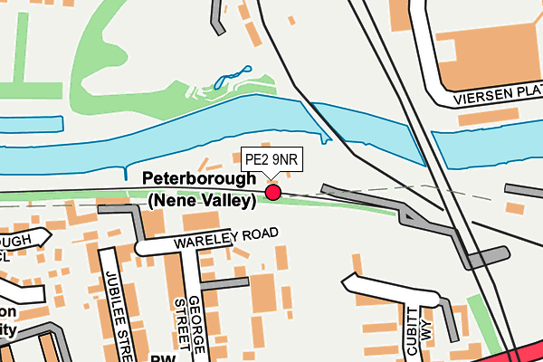
PE2 9NR is located in the Fletton and Woodston electoral ward, within the unitary authority of Peterborough and the English Parliamentary constituency of North West Cambridgeshire. The Sub Integrated Care Board (ICB) Location is NHS Cambridgeshire and Peterborough ICB - 06H and the police force is Cambridgeshire. This postcode has been in use since July 1986.


GetTheData
Source: OS OpenMap – Local (Ordnance Survey)
Source: OS VectorMap District (Ordnance Survey)
Licence: Open Government Licence (requires attribution)
| Easting | 518881 |
| Northing | 298125 |
| Latitude | 52.567989 |
| Longitude | -0.247431 |
GetTheData
Source: Open Postcode Geo
Licence: Open Government Licence
| Country | England |
| Postcode District | PE2 |
| ➜ PE2 open data dashboard ➜ See where PE2 is on a map ➜ Where is Peterborough? | |
GetTheData
Source: Land Registry Price Paid Data
Licence: Open Government Licence
Elevation or altitude of PE2 9NR as distance above sea level:
| Metres | Feet | |
|---|---|---|
| Elevation | 10m | 33ft |
Elevation is measured from the approximate centre of the postcode, to the nearest point on an OS contour line from OS Terrain 50, which has contour spacing of ten vertical metres.
➜ How high above sea level am I? Find the elevation of your current position using your device's GPS.
GetTheData
Source: Open Postcode Elevation
Licence: Open Government Licence
| Ward | Fletton And Woodston |
| Constituency | North West Cambridgeshire |
GetTheData
Source: ONS Postcode Database
Licence: Open Government Licence
| January 2024 | Anti-social behaviour | On or near Parking Area | 322m |
| January 2024 | Anti-social behaviour | On or near Parking Area | 322m |
| January 2024 | Anti-social behaviour | On or near Parking Area | 322m |
| ➜ Get more crime data in our Crime section | |||
GetTheData
Source: data.police.uk
Licence: Open Government Licence
| The Cherry Tree (Oundle Road) | Woodston | 259m |
| The Cherry Tree (Oundle Road) | Woodston | 281m |
| Town Bridge Corner (Oundle Road) | Fletton | 365m |
| Rivergate - Northbound (Bourges Boulevard) | Peterborough | 380m |
| Rivergate - Northbound (Bourges Boulevard) | Peterborough | 389m |
| Peterborough (Nene Valley Railway) | Woodston | 47m |
| Peterborough Station | 0.8km |
GetTheData
Source: NaPTAN
Licence: Open Government Licence
GetTheData
Source: ONS Postcode Database
Licence: Open Government Licence


➜ Get more ratings from the Food Standards Agency
GetTheData
Source: Food Standards Agency
Licence: FSA terms & conditions
| Last Collection | |||
|---|---|---|---|
| Location | Mon-Fri | Sat | Distance |
| Woodston Post Office | 18:30 | 11:45 | 264m |
| Rivergate-bridge Street | 18:45 | 13:00 | 402m |
| Thorpe Lea Road-vermont Grove | 18:00 | 12:15 | 460m |
GetTheData
Source: Dracos
Licence: Creative Commons Attribution-ShareAlike
| Facility | Distance |
|---|---|
| The Fitness Zone For Women (Peterborough) Wentworth Street, Peterborough Health and Fitness Gym, Studio | 470m |
| Energie Fitness (Peterborough) (Closed) Cowgate, Peterborough Health and Fitness Gym | 566m |
| Peterborough United Fc (The Weston Homes Stadium) London Road, Peterborough Grass Pitches | 572m |
GetTheData
Source: Active Places
Licence: Open Government Licence
| School | Phase of Education | Distance |
|---|---|---|
| St Augustine's CofE (Voluntary Aided) Junior School Palmerston Road, Peterborough, PE2 9DH | Primary | 523m |
| Clare Lodge Care of: Peterborough City Council, Town Hall, Bridge Street, Peterborough, PE1 1HF | Not applicable | 535m |
| Brewster Avenue Infant School Brewster Avenue, Woodston, Peterborough, PE2 9PN | Primary | 623m |
GetTheData
Source: Edubase
Licence: Open Government Licence
| Risk of PE2 9NR flooding from rivers and sea | Medium |
| ➜ PE2 9NR flood map | |
GetTheData
Source: Open Flood Risk by Postcode
Licence: Open Government Licence
The below table lists the International Territorial Level (ITL) codes (formerly Nomenclature of Territorial Units for Statistics (NUTS) codes) and Local Administrative Units (LAU) codes for PE2 9NR:
| ITL 1 Code | Name |
|---|---|
| TLH | East |
| ITL 2 Code | Name |
| TLH1 | East Anglia |
| ITL 3 Code | Name |
| TLH11 | Peterborough |
| LAU 1 Code | Name |
| E06000031 | Peterborough |
GetTheData
Source: ONS Postcode Directory
Licence: Open Government Licence
The below table lists the Census Output Area (OA), Lower Layer Super Output Area (LSOA), and Middle Layer Super Output Area (MSOA) for PE2 9NR:
| Code | Name | |
|---|---|---|
| OA | E00079015 | |
| LSOA | E01015622 | Peterborough 016A |
| MSOA | E02003252 | Peterborough 016 |
GetTheData
Source: ONS Postcode Directory
Licence: Open Government Licence
| PE2 9PD | George Street | 183m |
| PE2 9NF | Cubitt Way | 201m |
| PE2 9PF | Wareley Road | 207m |
| PE1 1ES | Viersen Platz | 218m |
| PE2 9NG | Cubitt Way | 223m |
| PE2 9PB | Oundle Road | 243m |
| PE2 9PH | Jubilee Street | 259m |
| PE2 9PA | Oundle Road | 278m |
| PE1 1ER | Viersen Platz | 314m |
| PE2 9LW | Flamborough Close | 331m |
GetTheData
Source: Open Postcode Geo; Land Registry Price Paid Data
Licence: Open Government Licence