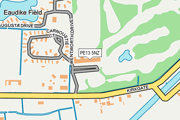
PE13 5NZ is located in the Leverington & Wisbech Rural electoral ward, within the local authority district of Fenland and the English Parliamentary constituency of North East Cambridgeshire. The Sub Integrated Care Board (ICB) Location is NHS Cambridgeshire and Peterborough ICB - 06H and the police force is Cambridgeshire. This postcode has been in use since December 1996.


GetTheData
Source: OS OpenMap – Local (Ordnance Survey)
Source: OS VectorMap District (Ordnance Survey)
Licence: Open Government Licence (requires attribution)
| Easting | 543407 |
| Northing | 316674 |
| Latitude | 52.728721 |
| Longitude | 0.122238 |
GetTheData
Source: Open Postcode Geo
Licence: Open Government Licence
| Country | England |
| Postcode District | PE13 |
| ➜ PE13 open data dashboard ➜ See where PE13 is on a map ➜ Where is Tydd St Giles? | |
GetTheData
Source: Land Registry Price Paid Data
Licence: Open Government Licence
Elevation or altitude of PE13 5NZ as distance above sea level:
| Metres | Feet | |
|---|---|---|
| Elevation | 0m | 0ft |
Elevation is measured from the approximate centre of the postcode, to the nearest point on an OS contour line from OS Terrain 50, which has contour spacing of ten vertical metres.
➜ How high above sea level am I? Find the elevation of your current position using your device's GPS.
GetTheData
Source: Open Postcode Elevation
Licence: Open Government Licence
| Ward | Leverington & Wisbech Rural |
| Constituency | North East Cambridgeshire |
GetTheData
Source: ONS Postcode Database
Licence: Open Government Licence
| May 2022 | Violence and sexual offences | On or near Park/Open Space | 388m |
| April 2022 | Anti-social behaviour | On or near Park/Open Space | 388m |
| November 2021 | Anti-social behaviour | On or near Kirkgate | 288m |
| ➜ Get more crime data in our Crime section | |||
GetTheData
Source: data.police.uk
Licence: Open Government Licence
| St Giles's Church (Church Lane) | Tydd St Giles | 781m |
| St Giles's Church (Church Lane) | Tydd St Giles | 793m |
| Hockland Road | Tydd St Giles | 872m |
| Church Lane | Tydd St Giles | 958m |
| Hockland Road | Tydd St Giles | 1,005m |
GetTheData
Source: NaPTAN
Licence: Open Government Licence
Estimated total energy consumption in PE13 5NZ by fuel type, 2015.
| Consumption (kWh) | 40,680 |
|---|---|
| Meter count | 6 |
| Mean (kWh/meter) | 6,780 |
| Median (kWh/meter) | 7,597 |
GetTheData
Source: Postcode level gas estimates: 2015 (experimental)
Source: Postcode level electricity estimates: 2015 (experimental)
Licence: Open Government Licence
GetTheData
Source: ONS Postcode Database
Licence: Open Government Licence


➜ Get more ratings from the Food Standards Agency
GetTheData
Source: Food Standards Agency
Licence: FSA terms & conditions
| Last Collection | |||
|---|---|---|---|
| Location | Mon-Fri | Sat | Distance |
| Tydd St Giles | 16:15 | 10:00 | 731m |
| Hicks Lane Lowgate | 16:00 | 07:00 | 1,694m |
| Manor Hill Corner | 15:30 | 08:00 | 2,694m |
GetTheData
Source: Dracos
Licence: Creative Commons Attribution-ShareAlike
| Facility | Distance |
|---|---|
| Tydd St Giles Golf And Country Club Kirkgate, Tydd St. Giles, Wisbech Health and Fitness Gym, Swimming Pool, Golf | 11m |
| Tydd St Giles Community Centre And Playing Fields Broad Drove East, Tydd St Giles Grass Pitches | 1.5km |
| Newton In The Isle Playing Field (Closed) Goodens Lane, Newton-in-the-isle, Wisbech Grass Pitches | 2km |
GetTheData
Source: Active Places
Licence: Open Government Licence
| School | Phase of Education | Distance |
|---|---|---|
| Kinderley Primary School Church Lane, Tydd St Giles, Church Lane, Wisbech, PE13 5LG | Primary | 1.1km |
| The Tydd St Mary Church of England Primary School Churchway, Tydd St Mary, Wisbech, PE13 5QY | Primary | 2.1km |
| Sutton St James Community Primary School Bells Drove, Sutton St James, Spalding, PE12 0JG | Primary | 3.9km |
GetTheData
Source: Edubase
Licence: Open Government Licence
| Risk of PE13 5NZ flooding from rivers and sea | Low |
| ➜ PE13 5NZ flood map | |
GetTheData
Source: Open Flood Risk by Postcode
Licence: Open Government Licence
The below table lists the International Territorial Level (ITL) codes (formerly Nomenclature of Territorial Units for Statistics (NUTS) codes) and Local Administrative Units (LAU) codes for PE13 5NZ:
| ITL 1 Code | Name |
|---|---|
| TLH | East |
| ITL 2 Code | Name |
| TLH1 | East Anglia |
| ITL 3 Code | Name |
| TLH12 | Cambridgeshire CC |
| LAU 1 Code | Name |
| E07000010 | Fenland |
GetTheData
Source: ONS Postcode Directory
Licence: Open Government Licence
The below table lists the Census Output Area (OA), Lower Layer Super Output Area (LSOA), and Middle Layer Super Output Area (MSOA) for PE13 5NZ:
| Code | Name | |
|---|---|---|
| OA | E00091311 | |
| LSOA | E01018097 | Fenland 001D |
| MSOA | E02003742 | Fenland 001 |
GetTheData
Source: ONS Postcode Directory
Licence: Open Government Licence
| PE13 5RR | Old Stable Gardens | 145m |
| PE13 5NE | Kirkgate | 243m |
| PE13 5PG | Sandy Lane | 480m |
| PE13 5LU | Eaudyke Bank | 610m |
| PE13 5LB | Kirkgate | 644m |
| PE13 5LE | Hockland Road | 746m |
| PE13 5LA | Church Lane | 837m |
| PE13 5LX | Cornfields | 904m |
| PE13 5LF | Hockland Road | 1005m |
| PE13 5ND | Hannath Road | 1103m |
GetTheData
Source: Open Postcode Geo; Land Registry Price Paid Data
Licence: Open Government Licence