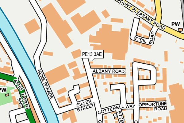
PE13 3AE is located in the Wisbech Riverside electoral ward, within the local authority district of Fenland and the English Parliamentary constituency of North East Cambridgeshire. The Sub Integrated Care Board (ICB) Location is NHS Cambridgeshire and Peterborough ICB - 06H and the police force is Cambridgeshire. This postcode has been in use since August 2005.


GetTheData
Source: OS OpenMap – Local (Ordnance Survey)
Source: OS VectorMap District (Ordnance Survey)
Licence: Open Government Licence (requires attribution)
| Easting | 546165 |
| Northing | 310367 |
| Latitude | 52.671306 |
| Longitude | 0.160234 |
GetTheData
Source: Open Postcode Geo
Licence: Open Government Licence
| Country | England |
| Postcode District | PE13 |
| ➜ PE13 open data dashboard ➜ See where PE13 is on a map ➜ Where is Wisbech? | |
GetTheData
Source: Land Registry Price Paid Data
Licence: Open Government Licence
Elevation or altitude of PE13 3AE as distance above sea level:
| Metres | Feet | |
|---|---|---|
| Elevation | 0m | 0ft |
Elevation is measured from the approximate centre of the postcode, to the nearest point on an OS contour line from OS Terrain 50, which has contour spacing of ten vertical metres.
➜ How high above sea level am I? Find the elevation of your current position using your device's GPS.
GetTheData
Source: Open Postcode Elevation
Licence: Open Government Licence
| Ward | Wisbech Riverside |
| Constituency | North East Cambridgeshire |
GetTheData
Source: ONS Postcode Database
Licence: Open Government Licence
| January 2024 | Burglary | On or near Sybil Road | 180m |
| January 2024 | Drugs | On or near Sybil Road | 180m |
| January 2024 | Anti-social behaviour | On or near Mill Close | 315m |
| ➜ Get more crime data in our Crime section | |||
GetTheData
Source: data.police.uk
Licence: Open Government Licence
| Bath Road (Mount Pleasant Road) | Wisbech | 226m |
| Asda Superstore (North End) | Wisbech | 273m |
| Asda Superstore (North End) | Wisbech | 274m |
| North End | Wisbech | 322m |
| Southwell Road (Mount Pleasant Road) | Wisbech | 324m |
GetTheData
Source: NaPTAN
Licence: Open Government Licence
| Percentage of properties with Next Generation Access | 100.0% |
| Percentage of properties with Superfast Broadband | 100.0% |
| Percentage of properties with Ultrafast Broadband | 0.0% |
| Percentage of properties with Full Fibre Broadband | 0.0% |
Superfast Broadband is between 30Mbps and 300Mbps
Ultrafast Broadband is > 300Mbps
| Percentage of properties unable to receive 2Mbps | 0.0% |
| Percentage of properties unable to receive 5Mbps | 0.0% |
| Percentage of properties unable to receive 10Mbps | 0.0% |
| Percentage of properties unable to receive 30Mbps | 0.0% |
GetTheData
Source: Ofcom
Licence: Ofcom Terms of Use (requires attribution)
GetTheData
Source: ONS Postcode Database
Licence: Open Government Licence

➜ Get more ratings from the Food Standards Agency
GetTheData
Source: Food Standards Agency
Licence: FSA terms & conditions
| Last Collection | |||
|---|---|---|---|
| Location | Mon-Fri | Sat | Distance |
| Leverington Road | 18:30 | 08:00 | 436m |
| Old Market | 18:30 | 11:45 | 611m |
| Harecroft Road Post Office | 18:30 | 12:00 | 688m |
GetTheData
Source: Dracos
Licence: Creative Commons Attribution-ShareAlike
| Facility | Distance |
|---|---|
| Shapers Gym North Street, Wisbech Health and Fitness Gym | 492m |
| Wisbech Cricket & Hockey Club Harecroft Road, Wisbech Grass Pitches, Artificial Grass Pitch | 638m |
| Wisbech Squash Club Harecroft Road, Wisbech Squash Courts | 666m |
GetTheData
Source: Active Places
Licence: Open Government Licence
| School | Phase of Education | Distance |
|---|---|---|
| Peckover Primary School Leverington Road, Wisbech, PE13 1PJ | Primary | 505m |
| Orchards Church of England Academy Cherry Road, Wisbech, PE13 3NP | Primary | 781m |
| Cambian Wisbech School Old Sessions House, 32 Somers Road, Wisbech, PE13 1JF | Not applicable | 837m |
GetTheData
Source: Edubase
Licence: Open Government Licence
| Risk of PE13 3AE flooding from rivers and sea | Medium |
| ➜ PE13 3AE flood map | |
GetTheData
Source: Open Flood Risk by Postcode
Licence: Open Government Licence
The below table lists the International Territorial Level (ITL) codes (formerly Nomenclature of Territorial Units for Statistics (NUTS) codes) and Local Administrative Units (LAU) codes for PE13 3AE:
| ITL 1 Code | Name |
|---|---|
| TLH | East |
| ITL 2 Code | Name |
| TLH1 | East Anglia |
| ITL 3 Code | Name |
| TLH12 | Cambridgeshire CC |
| LAU 1 Code | Name |
| E07000010 | Fenland |
GetTheData
Source: ONS Postcode Directory
Licence: Open Government Licence
The below table lists the Census Output Area (OA), Lower Layer Super Output Area (LSOA), and Middle Layer Super Output Area (MSOA) for PE13 3AE:
| Code | Name | |
|---|---|---|
| OA | E00091125 | |
| LSOA | E01018063 | Fenland 002A |
| MSOA | E02003743 | Fenland 002 |
GetTheData
Source: ONS Postcode Directory
Licence: Open Government Licence
| PE13 3AT | Lewellen Terrace | 47m |
| PE13 3AY | Albany Road | 67m |
| PE13 3AZ | York Terrace | 82m |
| PE13 3AU | Chase Street | 109m |
| PE13 3XE | Silver Street | 113m |
| PE13 3AP | De Havilland Road | 156m |
| PE13 3NG | Sybil Road | 166m |
| PE13 3BX | Nene Parade | 179m |
| PE13 3AR | Oakroyd Crescent | 184m |
| PE13 3NQ | Mount Pleasant Road | 209m |
GetTheData
Source: Open Postcode Geo; Land Registry Price Paid Data
Licence: Open Government Licence