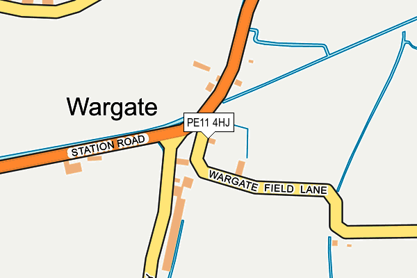
PE11 4HJ lies on Wargate Field Lane in Gosberton, Spalding. PE11 4HJ is located in the Donington, Quadring and Gosberton electoral ward, within the local authority district of South Holland and the English Parliamentary constituency of South Holland and The Deepings. The Sub Integrated Care Board (ICB) Location is NHS Lincolnshire ICB - 71E and the police force is Lincolnshire. This postcode has been in use since January 1980.


GetTheData
Source: OS OpenMap – Local (Ordnance Survey)
Source: OS VectorMap District (Ordnance Survey)
Licence: Open Government Licence (requires attribution)
| Easting | 523679 |
| Northing | 330544 |
| Latitude | 52.858187 |
| Longitude | -0.164507 |
GetTheData
Source: Open Postcode Geo
Licence: Open Government Licence
| Street | Wargate Field Lane |
| Locality | Gosberton |
| Town/City | Spalding |
| Country | England |
| Postcode District | PE11 |
| ➜ PE11 open data dashboard ➜ See where PE11 is on a map ➜ Where is Wargate? | |
GetTheData
Source: Land Registry Price Paid Data
Licence: Open Government Licence
Elevation or altitude of PE11 4HJ as distance above sea level:
| Metres | Feet | |
|---|---|---|
| Elevation | 0m | 0ft |
Elevation is measured from the approximate centre of the postcode, to the nearest point on an OS contour line from OS Terrain 50, which has contour spacing of ten vertical metres.
➜ How high above sea level am I? Find the elevation of your current position using your device's GPS.
GetTheData
Source: Open Postcode Elevation
Licence: Open Government Licence
| Ward | Donington, Quadring And Gosberton |
| Constituency | South Holland And The Deepings |
GetTheData
Source: ONS Postcode Database
Licence: Open Government Licence
| March 2021 | Violence and sexual offences | On or near Sweetlands Way | 306m |
| ➜ Get more crime data in our Crime section | |||
GetTheData
Source: data.police.uk
Licence: Open Government Licence
| The Five Bells Ph (Spalding Road) | Gosberton | 1,087m |
| Primary School (A152 High Street) | Gosberton | 1,090m |
| The Five Bells Ph (Spalding Road) | Gosberton | 1,101m |
| Primary School (A152 High Street) | Gosberton | 1,103m |
| Salem Street | Gosberton | 1,105m |
GetTheData
Source: NaPTAN
Licence: Open Government Licence
| Percentage of properties with Next Generation Access | 25.0% |
| Percentage of properties with Superfast Broadband | 0.0% |
| Percentage of properties with Ultrafast Broadband | 0.0% |
| Percentage of properties with Full Fibre Broadband | 0.0% |
Superfast Broadband is between 30Mbps and 300Mbps
Ultrafast Broadband is > 300Mbps
| Percentage of properties unable to receive 2Mbps | 0.0% |
| Percentage of properties unable to receive 5Mbps | 0.0% |
| Percentage of properties unable to receive 10Mbps | 0.0% |
| Percentage of properties unable to receive 30Mbps | 100.0% |
GetTheData
Source: Ofcom
Licence: Ofcom Terms of Use (requires attribution)
GetTheData
Source: ONS Postcode Database
Licence: Open Government Licence


➜ Get more ratings from the Food Standards Agency
GetTheData
Source: Food Standards Agency
Licence: FSA terms & conditions
| Last Collection | |||
|---|---|---|---|
| Location | Mon-Fri | Sat | Distance |
| Fern Drive | 17:30 | 12:00 | 4,987m |
GetTheData
Source: Dracos
Licence: Creative Commons Attribution-ShareAlike
| Facility | Distance |
|---|---|
| Glen Park Station Road, Surfleet, Spalding Artificial Grass Pitch, Grass Pitches | 2.6km |
| Spalding Golf Club A16 Bypass, Surfleet, Spalding Golf | 3.5km |
| The Glebe Field Off Knight Street, Pinchbeck, Spalding Grass Pitches | 4.7km |
GetTheData
Source: Active Places
Licence: Open Government Licence
| School | Phase of Education | Distance |
|---|---|---|
| Gosberton Academy High Street, Gosberton, Spalding, PE11 4NW | Primary | 1km |
| Gosberton House Academy 11 Westhorpe Road, Gosberton, Spalding, PE11 4EW | Not applicable | 1.3km |
| Surfleet Primary School Station Road, Surfleet, Spalding, PE11 4DB | Primary | 2.9km |
GetTheData
Source: Edubase
Licence: Open Government Licence
| Risk of PE11 4HJ flooding from rivers and sea | Medium |
| ➜ PE11 4HJ flood map | |
GetTheData
Source: Open Flood Risk by Postcode
Licence: Open Government Licence
The below table lists the International Territorial Level (ITL) codes (formerly Nomenclature of Territorial Units for Statistics (NUTS) codes) and Local Administrative Units (LAU) codes for PE11 4HJ:
| ITL 1 Code | Name |
|---|---|
| TLF | East Midlands (England) |
| ITL 2 Code | Name |
| TLF3 | Lincolnshire |
| ITL 3 Code | Name |
| TLF30 | Lincolnshire CC |
| LAU 1 Code | Name |
| E07000140 | South Holland |
GetTheData
Source: ONS Postcode Directory
Licence: Open Government Licence
The below table lists the Census Output Area (OA), Lower Layer Super Output Area (LSOA), and Middle Layer Super Output Area (MSOA) for PE11 4HJ:
| Code | Name | |
|---|---|---|
| OA | E00133288 | |
| LSOA | E01026247 | South Holland 001D |
| MSOA | E02005465 | South Holland 001 |
GetTheData
Source: ONS Postcode Directory
Licence: Open Government Licence
| PE11 4JB | Station Road | 205m |
| PE11 4JA | Belchmire Lane | 274m |
| PE11 4HD | Cawood Lane | 354m |
| PE11 4HB | Cawood Lane | 713m |
| PE11 4HE | Wargate Way | 769m |
| PE11 4HG | Belchmire Lane | 858m |
| PE11 4EQ | Bakers Yard | 860m |
| PE11 4HQ | Whitehall | 916m |
| PE11 4HF | Godfrey Avenue | 969m |
| PE11 4NY | Field Close | 1013m |
GetTheData
Source: Open Postcode Geo; Land Registry Price Paid Data
Licence: Open Government Licence