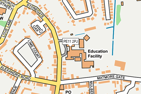
PE11 2PJ is located in the Spalding St Mary's electoral ward, within the local authority district of South Holland and the English Parliamentary constituency of South Holland and The Deepings. The Sub Integrated Care Board (ICB) Location is NHS Lincolnshire ICB - 71E and the police force is Lincolnshire. This postcode has been in use since January 1980.


GetTheData
Source: OS OpenMap – Local (Ordnance Survey)
Source: OS VectorMap District (Ordnance Survey)
Licence: Open Government Licence (requires attribution)
| Easting | 525325 |
| Northing | 322277 |
| Latitude | 52.783530 |
| Longitude | -0.143242 |
GetTheData
Source: Open Postcode Geo
Licence: Open Government Licence
| Country | England |
| Postcode District | PE11 |
| ➜ PE11 open data dashboard ➜ See where PE11 is on a map ➜ Where is Spalding? | |
GetTheData
Source: Land Registry Price Paid Data
Licence: Open Government Licence
Elevation or altitude of PE11 2PJ as distance above sea level:
| Metres | Feet | |
|---|---|---|
| Elevation | 10m | 33ft |
Elevation is measured from the approximate centre of the postcode, to the nearest point on an OS contour line from OS Terrain 50, which has contour spacing of ten vertical metres.
➜ How high above sea level am I? Find the elevation of your current position using your device's GPS.
GetTheData
Source: Open Postcode Elevation
Licence: Open Government Licence
| Ward | Spalding St Mary's |
| Constituency | South Holland And The Deepings |
GetTheData
Source: ONS Postcode Database
Licence: Open Government Licence
| November 2023 | Anti-social behaviour | On or near Thornton Road | 429m |
| August 2023 | Criminal damage and arson | On or near Thornton Road | 429m |
| January 2023 | Violence and sexual offences | On or near Thornton Road | 429m |
| ➜ Get more crime data in our Crime section | |||
GetTheData
Source: data.police.uk
Licence: Open Government Licence
| High School (Stonegate) | Spalding | 49m |
| Oak Court (Stonegate) | Spalding | 177m |
| Oak Court (Stonegate) | Spalding | 191m |
| Grange Drive (Halmer Gate) | Spalding | 289m |
| Grange Drive (Halmer Gate) | Spalding | 303m |
| Spalding Station | 1.1km |
GetTheData
Source: NaPTAN
Licence: Open Government Licence
GetTheData
Source: ONS Postcode Database
Licence: Open Government Licence


➜ Get more ratings from the Food Standards Agency
GetTheData
Source: Food Standards Agency
Licence: FSA terms & conditions
| Last Collection | |||
|---|---|---|---|
| Location | Mon-Fri | Sat | Distance |
| Westlode Street | 17:45 | 12:00 | 826m |
| Horseshoe Road Bridge | 16:00 | 11:00 | 990m |
| Springfields | 17:40 | 12:00 | 1,998m |
GetTheData
Source: Dracos
Licence: Creative Commons Attribution-ShareAlike
| Facility | Distance |
|---|---|
| Spalding High School Stonegate, Spalding Health and Fitness Gym, Grass Pitches, Sports Hall | 0m |
| Spalding Parish Ce Day School Clay Lake, Spalding Grass Pitches | 336m |
| Gleed Boys School (Closed) Halmer Gardens, Spalding Grass Pitches, Artificial Grass Pitch, Sports Hall, Health and Fitness Gym | 358m |
GetTheData
Source: Active Places
Licence: Open Government Licence
| School | Phase of Education | Distance |
|---|---|---|
| Spalding High School Stonegate, Spalding, PE11 2PJ | Secondary | 67m |
| Springwell Alternative Academy Spalding Matmore Gate, Spalding, PE11 2PN | Not applicable | 220m |
| Spalding Parish Church of England Day School Clay Lake, Spalding, PE11 2QG | Primary | 336m |
GetTheData
Source: Edubase
Licence: Open Government Licence
| Risk of PE11 2PJ flooding from rivers and sea | Medium |
| ➜ PE11 2PJ flood map | |
GetTheData
Source: Open Flood Risk by Postcode
Licence: Open Government Licence
The below table lists the International Territorial Level (ITL) codes (formerly Nomenclature of Territorial Units for Statistics (NUTS) codes) and Local Administrative Units (LAU) codes for PE11 2PJ:
| ITL 1 Code | Name |
|---|---|
| TLF | East Midlands (England) |
| ITL 2 Code | Name |
| TLF3 | Lincolnshire |
| ITL 3 Code | Name |
| TLF30 | Lincolnshire CC |
| LAU 1 Code | Name |
| E07000140 | South Holland |
GetTheData
Source: ONS Postcode Directory
Licence: Open Government Licence
The below table lists the Census Output Area (OA), Lower Layer Super Output Area (LSOA), and Middle Layer Super Output Area (MSOA) for PE11 2PJ:
| Code | Name | |
|---|---|---|
| OA | E00133418 | |
| LSOA | E01026269 | South Holland 007B |
| MSOA | E02005471 | South Holland 007 |
GetTheData
Source: ONS Postcode Directory
Licence: Open Government Licence
| PE11 2PH | Stonegate | 67m |
| PE11 2PX | Alexandra Road | 206m |
| PE11 2PN | Matmore Gate | 206m |
| PE11 2DX | Grange Drive | 207m |
| PE11 2PQ | Stonegate | 209m |
| PE11 2PP | Stonegate | 209m |
| PE11 2QJ | Mulberry Way | 237m |
| PE11 2PR | Cameron Drive | 244m |
| PE11 2PE | Love Lane | 257m |
| PE11 2QL | Morus Close | 266m |
GetTheData
Source: Open Postcode Geo; Land Registry Price Paid Data
Licence: Open Government Licence