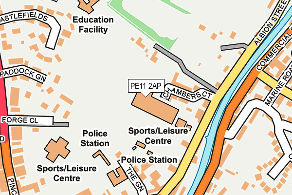
PE11 2AP is located in the Spalding Castle electoral ward, within the local authority district of South Holland and the English Parliamentary constituency of South Holland and The Deepings. The Sub Integrated Care Board (ICB) Location is NHS Lincolnshire ICB - 71E and the police force is Lincolnshire. This postcode has been in use since January 1980.


GetTheData
Source: OS OpenMap – Local (Ordnance Survey)
Source: OS VectorMap District (Ordnance Survey)
Licence: Open Government Licence (requires attribution)
| Easting | 525065 |
| Northing | 323136 |
| Latitude | 52.791308 |
| Longitude | -0.146767 |
GetTheData
Source: Open Postcode Geo
Licence: Open Government Licence
| Country | England |
| Postcode District | PE11 |
| ➜ PE11 open data dashboard ➜ See where PE11 is on a map ➜ Where is Spalding? | |
GetTheData
Source: Land Registry Price Paid Data
Licence: Open Government Licence
Elevation or altitude of PE11 2AP as distance above sea level:
| Metres | Feet | |
|---|---|---|
| Elevation | 10m | 33ft |
Elevation is measured from the approximate centre of the postcode, to the nearest point on an OS contour line from OS Terrain 50, which has contour spacing of ten vertical metres.
➜ How high above sea level am I? Find the elevation of your current position using your device's GPS.
GetTheData
Source: Open Postcode Elevation
Licence: Open Government Licence
| Ward | Spalding Castle |
| Constituency | South Holland And The Deepings |
GetTheData
Source: ONS Postcode Database
Licence: Open Government Licence
| June 2022 | Public order | On or near Chambers Court | 90m |
| June 2022 | Bicycle theft | On or near Chambers Court | 90m |
| June 2022 | Anti-social behaviour | On or near Chambers Court | 90m |
| ➜ Get more crime data in our Crime section | |||
GetTheData
Source: data.police.uk
Licence: Open Government Licence
| Kings Road (Pinchbeck Road) | Spalding | 289m |
| Kings Road (Pinchbeck Road) | Spalding | 308m |
| Health Centre (West Elloe Avenue) | Spalding | 373m |
| Chappell Centre (Pinchbeck Road) | Spalding | 377m |
| Holland Road (High Street) | Spalding | 396m |
| Spalding Station | 0.7km |
GetTheData
Source: NaPTAN
Licence: Open Government Licence
GetTheData
Source: ONS Postcode Database
Licence: Open Government Licence


➜ Get more ratings from the Food Standards Agency
GetTheData
Source: Food Standards Agency
Licence: FSA terms & conditions
| Last Collection | |||
|---|---|---|---|
| Location | Mon-Fri | Sat | Distance |
| Westlode Street | 17:45 | 12:00 | 457m |
| Horseshoe Road Bridge | 16:00 | 11:00 | 788m |
| Springfields | 17:40 | 12:00 | 1,510m |
GetTheData
Source: Dracos
Licence: Creative Commons Attribution-ShareAlike
| Facility | Distance |
|---|---|
| Castle Sports Centre And Swimming Pool Albion Street, Spalding Sports Hall, Indoor Bowls, Athletics, Swimming Pool, Health and Fitness Gym, Grass Pitches, Outdoor Tennis Courts, Cycling | 8m |
| The Garth School Pinchbeck Road, Spalding Sports Hall, Swimming Pool | 248m |
| Pro Bodies Health And Fitness High Street, Spalding Health and Fitness Gym | 293m |
GetTheData
Source: Active Places
Licence: Open Government Licence
| School | Phase of Education | Distance |
|---|---|---|
| Tulip Academy Neville Avenue, Spalding, PE11 2EH | Not applicable | 871m |
| Spalding Academy Neville Avenue, Spalding, PE11 2EJ | Secondary | 881m |
| St Paul's Community Primary and Nursery School, Spalding Queens Road, Spalding, PE11 2JQ | Primary | 908m |
GetTheData
Source: Edubase
Licence: Open Government Licence
| Risk of PE11 2AP flooding from rivers and sea | Medium |
| ➜ PE11 2AP flood map | |
GetTheData
Source: Open Flood Risk by Postcode
Licence: Open Government Licence
The below table lists the International Territorial Level (ITL) codes (formerly Nomenclature of Territorial Units for Statistics (NUTS) codes) and Local Administrative Units (LAU) codes for PE11 2AP:
| ITL 1 Code | Name |
|---|---|
| TLF | East Midlands (England) |
| ITL 2 Code | Name |
| TLF3 | Lincolnshire |
| ITL 3 Code | Name |
| TLF30 | Lincolnshire CC |
| LAU 1 Code | Name |
| E07000140 | South Holland |
GetTheData
Source: ONS Postcode Directory
Licence: Open Government Licence
The below table lists the Census Output Area (OA), Lower Layer Super Output Area (LSOA), and Middle Layer Super Output Area (MSOA) for PE11 2AP:
| Code | Name | |
|---|---|---|
| OA | E00133384 | |
| LSOA | E01032995 | South Holland 006F |
| MSOA | E02005470 | South Holland 006 |
GetTheData
Source: ONS Postcode Directory
Licence: Open Government Licence
| PE11 2QP | Chambers Court | 76m |
| PE11 2AG | The Green | 146m |
| PE11 2AJ | Albion Street | 151m |
| PE11 2AU | Albion Street | 172m |
| PE11 1XD | Forge Close | 191m |
| PE11 2HA | Commercial Road | 195m |
| PE11 2BF | Albion Wharf | 208m |
| PE11 1UW | River View Terrace | 208m |
| PE11 1TX | High Street | 219m |
| PE11 2AQ | Westlode Street | 220m |
GetTheData
Source: Open Postcode Geo; Land Registry Price Paid Data
Licence: Open Government Licence