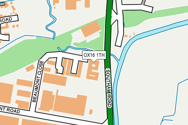
OX16 1TH is located in the Banbury Cross and Neithrop electoral ward, within the local authority district of Cherwell and the English Parliamentary constituency of Banbury. The Sub Integrated Care Board (ICB) Location is NHS Buckinghamshire, Oxfordshire and Berkshire West ICB - 10Q and the police force is Thames Valley. This postcode has been in use since December 2000.


GetTheData
Source: OS OpenMap – Local (Ordnance Survey)
Source: OS VectorMap District (Ordnance Survey)
Licence: Open Government Licence (requires attribution)
| Easting | 445506 |
| Northing | 242374 |
| Latitude | 52.077864 |
| Longitude | -1.337412 |
GetTheData
Source: Open Postcode Geo
Licence: Open Government Licence
| Country | England |
| Postcode District | OX16 |
| ➜ OX16 open data dashboard ➜ See where OX16 is on a map ➜ Where is Banbury? | |
GetTheData
Source: Land Registry Price Paid Data
Licence: Open Government Licence
Elevation or altitude of OX16 1TH as distance above sea level:
| Metres | Feet | |
|---|---|---|
| Elevation | 100m | 328ft |
Elevation is measured from the approximate centre of the postcode, to the nearest point on an OS contour line from OS Terrain 50, which has contour spacing of ten vertical metres.
➜ How high above sea level am I? Find the elevation of your current position using your device's GPS.
GetTheData
Source: Open Postcode Elevation
Licence: Open Government Licence
| Ward | Banbury Cross And Neithrop |
| Constituency | Banbury |
GetTheData
Source: ONS Postcode Database
Licence: Open Government Licence
| December 2023 | Vehicle crime | On or near Hart Close | 434m |
| December 2023 | Criminal damage and arson | On or near Hart Close | 434m |
| November 2023 | Drugs | On or near Griffith Road | 367m |
| ➜ Get more crime data in our Crime section | |||
GetTheData
Source: data.police.uk
Licence: Open Government Licence
| Sir Henry Jake Close (Lapsley Drive) | Hanwell Fields | 445m |
| Sir Henry Jake Close (Lapsley Drive) | Hanwell Fields | 456m |
| Griffith Road Play Area (Lapsley Drive) | Hanwell Fields | 462m |
| Banbury Office Village (Noral Way) | Banbury | 493m |
| Lord Grandison Way (Lapsley Drive) | Hanwell Fields | 514m |
| Banbury Station | 2.1km |
GetTheData
Source: NaPTAN
Licence: Open Government Licence
GetTheData
Source: ONS Postcode Database
Licence: Open Government Licence

➜ Get more ratings from the Food Standards Agency
GetTheData
Source: Food Standards Agency
Licence: FSA terms & conditions
| Last Collection | |||
|---|---|---|---|
| Location | Mon-Fri | Sat | Distance |
| Rotery Way | 16:00 | 08:30 | 570m |
| Market Place | 18:20 | 11:00 | 1,751m |
| Bridge Street | 18:15 | 11:00 | 1,785m |
GetTheData
Source: Dracos
Licence: Creative Commons Attribution-ShareAlike
| Facility | Distance |
|---|---|
| Hanwell Fields Community School Rotary Way, Banbury Grass Pitches | 593m |
| Puregym (Banbury Cross Retail Park) Lockheed Close, Banbury Health and Fitness Gym | 689m |
| Hanwell Fields Recreation Ground Dukes Meadow Drive, Banbury Grass Pitches | 692m |
GetTheData
Source: Active Places
Licence: Open Government Licence
| School | Phase of Education | Distance |
|---|---|---|
| Hanwell Fields Community School Rotary Way, Banbury, OX16 1ER | Primary | 588m |
| Cherry Fields Primary School Wardington Road, Banbury, OX16 2DF | Primary | 848m |
| Hardwick Primary School Ferriston, Banbury, OX16 1XE | Primary | 1.3km |
GetTheData
Source: Edubase
Licence: Open Government Licence
| Risk of OX16 1TH flooding from rivers and sea | Medium |
| ➜ OX16 1TH flood map | |
GetTheData
Source: Open Flood Risk by Postcode
Licence: Open Government Licence
The below table lists the International Territorial Level (ITL) codes (formerly Nomenclature of Territorial Units for Statistics (NUTS) codes) and Local Administrative Units (LAU) codes for OX16 1TH:
| ITL 1 Code | Name |
|---|---|
| TLJ | South East (England) |
| ITL 2 Code | Name |
| TLJ1 | Berkshire, Buckinghamshire and Oxfordshire |
| ITL 3 Code | Name |
| TLJ14 | Oxfordshire CC |
| LAU 1 Code | Name |
| E07000177 | Cherwell |
GetTheData
Source: ONS Postcode Directory
Licence: Open Government Licence
The below table lists the Census Output Area (OA), Lower Layer Super Output Area (LSOA), and Middle Layer Super Output Area (MSOA) for OX16 1TH:
| Code | Name | |
|---|---|---|
| OA | E00144950 | |
| LSOA | E01028445 | Cherwell 003A |
| MSOA | E02005923 | Cherwell 003 |
GetTheData
Source: ONS Postcode Directory
Licence: Open Government Licence
| OX16 1TG | Beaumont Close | 123m |
| OX16 2SX | Southam Road | 134m |
| OX16 1EG | Booth Road | 332m |
| OX16 1EF | Griffith Road | 373m |
| OX16 1EE | Griffith Road | 376m |
| OX16 1RH | Beaumont Road | 384m |
| OX16 1EX | Lord Elwood Road | 417m |
| OX16 1EN | Lapsley Drive | 430m |
| OX16 1EH | Hart Close | 442m |
| OX16 1EP | Lord Grandison Way | 452m |
GetTheData
Source: Open Postcode Geo; Land Registry Price Paid Data
Licence: Open Government Licence