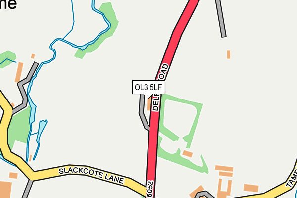
OL3 5LF lies on Denshaw Road in Delph, Oldham. OL3 5LF is located in the Saddleworth North electoral ward, within the metropolitan district of Oldham and the English Parliamentary constituency of Oldham East and Saddleworth. The Sub Integrated Care Board (ICB) Location is NHS Greater Manchester ICB - 00Y and the police force is Greater Manchester. This postcode has been in use since May 2004.


GetTheData
Source: OS OpenMap – Local (Ordnance Survey)
Source: OS VectorMap District (Ordnance Survey)
Licence: Open Government Licence (requires attribution)
| Easting | 397318 |
| Northing | 409375 |
| Latitude | 53.580960 |
| Longitude | -2.041981 |
GetTheData
Source: Open Postcode Geo
Licence: Open Government Licence
| Street | Denshaw Road |
| Locality | Delph |
| Town/City | Oldham |
| Country | England |
| Postcode District | OL3 |
| ➜ OL3 open data dashboard ➜ See where OL3 is on a map | |
GetTheData
Source: Land Registry Price Paid Data
Licence: Open Government Licence
Elevation or altitude of OL3 5LF as distance above sea level:
| Metres | Feet | |
|---|---|---|
| Elevation | 250m | 820ft |
Elevation is measured from the approximate centre of the postcode, to the nearest point on an OS contour line from OS Terrain 50, which has contour spacing of ten vertical metres.
➜ How high above sea level am I? Find the elevation of your current position using your device's GPS.
GetTheData
Source: Open Postcode Elevation
Licence: Open Government Licence
| Ward | Saddleworth North |
| Constituency | Oldham East And Saddleworth |
GetTheData
Source: ONS Postcode Database
Licence: Open Government Licence
| Denshaw Rd/Tame Ln (Denshaw Rd) | Slackcote | 171m |
| Denshaw Rd/Tame Ln (Denshaw Rd) | Slackcote | 228m |
| Delph Rd/Summer Hill Clough (Delph Rd) | Denshaw | 389m |
| Denshaw Rd/Summer Hill Clough (Delph Road) | Denshaw | 403m |
| Denshaw Rd/New Barn Rd (Denshaw Rd) | Slackcote | 413m |
| Greenfield Station | 5km |
GetTheData
Source: NaPTAN
Licence: Open Government Licence
| Median download speed | 39.1Mbps |
| Average download speed | 44.4Mbps |
| Maximum download speed | 80.00Mbps |
| Median upload speed | 9.8Mbps |
| Average upload speed | 11.2Mbps |
| Maximum upload speed | 20.00Mbps |
GetTheData
Source: Ofcom
Licence: Ofcom Terms of Use (requires attribution)
GetTheData
Source: ONS Postcode Database
Licence: Open Government Licence


➜ Get more ratings from the Food Standards Agency
GetTheData
Source: Food Standards Agency
Licence: FSA terms & conditions
| Last Collection | |||
|---|---|---|---|
| Location | Mon-Fri | Sat | Distance |
| Delph Lane | 17:30 | 12:05 | 1,831m |
| Delph P.o. | 17:00 | 12:00 | 1,918m |
| New Delph | 16:15 | 11:15 | 2,341m |
GetTheData
Source: Dracos
Licence: Creative Commons Attribution-ShareAlike
| Facility | Distance |
|---|---|
| Friarmere Cricket Club Denshaw Road, Delph Grass Pitches | 492m |
| Bishops Park (Oldham) Grains Bar, Oldham Grass Pitches, Golf | 1.5km |
| Delph And Dobcross Cricket Club Ainsbrook Avenue, Delph, Oldham Grass Pitches | 2.3km |
GetTheData
Source: Active Places
Licence: Open Government Licence
| School | Phase of Education | Distance |
|---|---|---|
| Christ Church CofE Primary School Delph Road, Delph Road, Oldham, OL3 5RY | Primary | 1.1km |
| Delph Primary School Denshaw Road, Delph, Oldham, OL3 5HN | Primary | 1.6km |
| St Thomas Moorside CofE (VA) Primary School Coleridge Road, Sholver, Oldham, OL1 4RL | Primary | 2.6km |
GetTheData
Source: Edubase
Licence: Open Government Licence
The below table lists the International Territorial Level (ITL) codes (formerly Nomenclature of Territorial Units for Statistics (NUTS) codes) and Local Administrative Units (LAU) codes for OL3 5LF:
| ITL 1 Code | Name |
|---|---|
| TLD | North West (England) |
| ITL 2 Code | Name |
| TLD3 | Greater Manchester |
| ITL 3 Code | Name |
| TLD37 | Greater Manchester North East |
| LAU 1 Code | Name |
| E08000004 | Oldham |
GetTheData
Source: ONS Postcode Directory
Licence: Open Government Licence
The below table lists the Census Output Area (OA), Lower Layer Super Output Area (LSOA), and Middle Layer Super Output Area (MSOA) for OL3 5LF:
| Code | Name | |
|---|---|---|
| OA | E00027423 | |
| LSOA | E01005414 | Oldham 006C |
| MSOA | E02001103 | Oldham 006 |
GetTheData
Source: ONS Postcode Directory
Licence: Open Government Licence
| OL3 5TS | Denshaw Road | 211m |
| OL3 5SU | Horest Lane | 269m |
| OL3 5TP | Slackcote Lane | 370m |
| OL3 5TD | Slackcote Lane | 395m |
| OL3 5TN | New Barn | 465m |
| OL3 5TR | West View | 492m |
| OL3 5ST | Horest Lane | 502m |
| OL3 5SS | Oldham Road | 518m |
| OL3 5SP | Oldham Road | 642m |
| OL3 5TZ | Slackgate Lane | 654m |
GetTheData
Source: Open Postcode Geo; Land Registry Price Paid Data
Licence: Open Government Licence