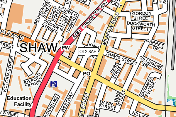
OL2 8AE is located in the Shaw electoral ward, within the metropolitan district of Oldham and the English Parliamentary constituency of Oldham East and Saddleworth. The Sub Integrated Care Board (ICB) Location is NHS Greater Manchester ICB - 00Y and the police force is Greater Manchester. This postcode has been in use since January 1980.


GetTheData
Source: OS OpenMap – Local (Ordnance Survey)
Source: OS VectorMap District (Ordnance Survey)
Licence: Open Government Licence (requires attribution)
| Easting | 393904 |
| Northing | 409082 |
| Latitude | 53.578297 |
| Longitude | -2.093540 |
GetTheData
Source: Open Postcode Geo
Licence: Open Government Licence
| Country | England |
| Postcode District | OL2 |
| ➜ OL2 open data dashboard ➜ See where OL2 is on a map ➜ Where is Shaw? | |
GetTheData
Source: Land Registry Price Paid Data
Licence: Open Government Licence
Elevation or altitude of OL2 8AE as distance above sea level:
| Metres | Feet | |
|---|---|---|
| Elevation | 180m | 591ft |
Elevation is measured from the approximate centre of the postcode, to the nearest point on an OS contour line from OS Terrain 50, which has contour spacing of ten vertical metres.
➜ How high above sea level am I? Find the elevation of your current position using your device's GPS.
GetTheData
Source: Open Postcode Elevation
Licence: Open Government Licence
| Ward | Shaw |
| Constituency | Oldham East And Saddleworth |
GetTheData
Source: ONS Postcode Database
Licence: Open Government Licence
| June 2022 | Robbery | On or near Milne Street | 269m |
| ➜ Get more crime data in our Crime section | |||
GetTheData
Source: data.police.uk
Licence: Open Government Licence
| Milnrow Rd/Travis St (Milnrow Rd) | Shaw | 42m |
| Milnrow Rd/Travis St (Milnrow Rd) | Shaw | 47m |
| Milnrow Rd/King Albert St (Milnrow Rd) | Shaw | 56m |
| Beal Ln/Park St (Beal Ln) | Shaw | 98m |
| Rochdale Rd/Crompton Way (Rochdale Rd) | Shaw | 138m |
| Shaw And Crompton (Manchester Metrolink) (Beal Lane) | Shaw | 357m |
| Rochdale Station | 5.3km |
GetTheData
Source: NaPTAN
Licence: Open Government Licence
GetTheData
Source: ONS Postcode Database
Licence: Open Government Licence


➜ Get more ratings from the Food Standards Agency
GetTheData
Source: Food Standards Agency
Licence: FSA terms & conditions
| Last Collection | |||
|---|---|---|---|
| Location | Mon-Fri | Sat | Distance |
| Shaw P.o. | 18:00 | 12:05 | 85m |
| High Street Shaw | 17:50 | 315m | |
| 48 Salt Street | 17:00 | 11:45 | 422m |
GetTheData
Source: Dracos
Licence: Creative Commons Attribution-ShareAlike
| Facility | Distance |
|---|---|
| Crompton Fitness Centre (Closed) Farrow Street, Shaw, Oldham Swimming Pool, Health and Fitness Gym | 278m |
| Shaw Lifelong Learning Centre High Street, Shaw, Oldham Sports Hall | 318m |
| Elite Fitness Grains Road, Shaw, Oldham Sports Hall, Health and Fitness Gym, Studio | 590m |
GetTheData
Source: Active Places
Licence: Open Government Licence
| School | Phase of Education | Distance |
|---|---|---|
| Farrowdale House School Farrowdale House Farrow st, Shaw, Oldham, OL2 7AD | Not applicable | 275m |
| East Crompton St James CofE Primary School St James Street, Shaw, Oldham, OL2 7TD | Primary | 297m |
| Beal Vale Primary School Salts Street, Shaw, Salts Street, Shaw, Oldham, OL2 7SY | Primary | 354m |
GetTheData
Source: Edubase
Licence: Open Government Licence
The below table lists the International Territorial Level (ITL) codes (formerly Nomenclature of Territorial Units for Statistics (NUTS) codes) and Local Administrative Units (LAU) codes for OL2 8AE:
| ITL 1 Code | Name |
|---|---|
| TLD | North West (England) |
| ITL 2 Code | Name |
| TLD3 | Greater Manchester |
| ITL 3 Code | Name |
| TLD37 | Greater Manchester North East |
| LAU 1 Code | Name |
| E08000004 | Oldham |
GetTheData
Source: ONS Postcode Directory
Licence: Open Government Licence
The below table lists the Census Output Area (OA), Lower Layer Super Output Area (LSOA), and Middle Layer Super Output Area (MSOA) for OL2 8AE:
| Code | Name | |
|---|---|---|
| OA | E00027572 | |
| LSOA | E01005445 | Oldham 002D |
| MSOA | E02001099 | Oldham 002 |
GetTheData
Source: ONS Postcode Directory
Licence: Open Government Licence
| OL2 8AD | Rochdale Road | 25m |
| OL2 8AP | Milnrow Road | 26m |
| OL2 8AJ | Chapel Street | 36m |
| OL2 8AH | King Albert Street | 50m |
| OL2 8AF | Co Operative Street | 69m |
| OL2 8QX | Rochdale Road | 75m |
| OL2 8AA | Collinge Street | 77m |
| OL2 8AQ | Provident Street | 82m |
| OL2 8EQ | Milnrow Road | 101m |
| OL2 8AB | Kershaw Street East | 104m |
GetTheData
Source: Open Postcode Geo; Land Registry Price Paid Data
Licence: Open Government Licence