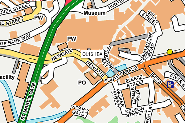
OL16 1BA is located in the Central Rochdale electoral ward, within the metropolitan district of Rochdale and the English Parliamentary constituency of Rochdale. The Sub Integrated Care Board (ICB) Location is NHS Greater Manchester ICB - 01D and the police force is Greater Manchester. This postcode has been in use since January 1980.


GetTheData
Source: OS OpenMap – Local (Ordnance Survey)
Source: OS VectorMap District (Ordnance Survey)
Licence: Open Government Licence (requires attribution)
| Easting | 389565 |
| Northing | 413401 |
| Latitude | 53.617048 |
| Longitude | -2.159217 |
GetTheData
Source: Open Postcode Geo
Licence: Open Government Licence
| Country | England |
| Postcode District | OL16 |
| ➜ OL16 open data dashboard ➜ See where OL16 is on a map ➜ Where is Rochdale? | |
GetTheData
Source: Land Registry Price Paid Data
Licence: Open Government Licence
Elevation or altitude of OL16 1BA as distance above sea level:
| Metres | Feet | |
|---|---|---|
| Elevation | 130m | 427ft |
Elevation is measured from the approximate centre of the postcode, to the nearest point on an OS contour line from OS Terrain 50, which has contour spacing of ten vertical metres.
➜ How high above sea level am I? Find the elevation of your current position using your device's GPS.
GetTheData
Source: Open Postcode Elevation
Licence: Open Government Licence
| Ward | Central Rochdale |
| Constituency | Rochdale |
GetTheData
Source: ONS Postcode Database
Licence: Open Government Licence
| Newgate/The Esplanade (Newgate) | Rochdale | 36m |
| Ellen Smith's Office (Newgate) | Rochdale | 40m |
| Newgate/St Mary's Gate (Newgate) | Rochdale | 50m |
| The Esplanade/Rochdale P.o. (The Esplanade) | Rochdale | 83m |
| Hunters Ln/St Mary's Gate (Hunters Ln) | Town Head | 188m |
| Rochdale Interchange (Manchester Metrolink) (Smith Street) | Rochdale | 260m |
| Rochdale Railway Station (Manchester Metrolink) (Maclure Rd) | Rochdale | 743m |
| Rochdale Station | 0.8km |
| Castleton (Manchester) Station | 3.1km |
| Smithy Bridge Station | 3.5km |
GetTheData
Source: NaPTAN
Licence: Open Government Licence
| Percentage of properties with Next Generation Access | 100.0% |
| Percentage of properties with Superfast Broadband | 100.0% |
| Percentage of properties with Ultrafast Broadband | 0.0% |
| Percentage of properties with Full Fibre Broadband | 0.0% |
Superfast Broadband is between 30Mbps and 300Mbps
Ultrafast Broadband is > 300Mbps
| Percentage of properties unable to receive 2Mbps | 0.0% |
| Percentage of properties unable to receive 5Mbps | 0.0% |
| Percentage of properties unable to receive 10Mbps | 0.0% |
| Percentage of properties unable to receive 30Mbps | 0.0% |
GetTheData
Source: Ofcom
Licence: Ofcom Terms of Use (requires attribution)
GetTheData
Source: ONS Postcode Database
Licence: Open Government Licence


➜ Get more ratings from the Food Standards Agency
GetTheData
Source: Food Standards Agency
Licence: FSA terms & conditions
| Last Collection | |||
|---|---|---|---|
| Location | Mon-Fri | Sat | Distance |
| Rochdale Fpo | 18:30 | 12:00 | 57m |
| Packer Street | 19:00 | 79m | |
| Toad Lane | 17:45 | 11:00 | 230m |
GetTheData
Source: Dracos
Licence: Creative Commons Attribution-ShareAlike
| Facility | Distance |
|---|---|
| Jd Gyms (Rochdale) Yorkshire Street, Rochdale Health and Fitness Gym, Studio | 186m |
| St Johns Rc Primary School Ann Street, Rochdale Grass Pitches | 667m |
| Central Leisure Centre (Closed) Entwisle Road, Rochdale Swimming Pool, Health and Fitness Gym, Studio | 689m |
GetTheData
Source: Active Places
Licence: Open Government Licence
| School | Phase of Education | Distance |
|---|---|---|
| Broadfield Community Primary School Sparrow Hill, Rochdale, OL16 1QT | Primary | 290m |
| Rochdale Sixth Form College College Road, Rochdale, OL12 6HY | 16 plus | 351m |
| Howard Street Nursery School Howard Street, Rochdale, OL12 0PP | Nursery | 550m |
GetTheData
Source: Edubase
Licence: Open Government Licence
| Risk of OL16 1BA flooding from rivers and sea | Medium |
| ➜ OL16 1BA flood map | |
GetTheData
Source: Open Flood Risk by Postcode
Licence: Open Government Licence
The below table lists the International Territorial Level (ITL) codes (formerly Nomenclature of Territorial Units for Statistics (NUTS) codes) and Local Administrative Units (LAU) codes for OL16 1BA:
| ITL 1 Code | Name |
|---|---|
| TLD | North West (England) |
| ITL 2 Code | Name |
| TLD3 | Greater Manchester |
| ITL 3 Code | Name |
| TLD37 | Greater Manchester North East |
| LAU 1 Code | Name |
| E08000005 | Rochdale |
GetTheData
Source: ONS Postcode Directory
Licence: Open Government Licence
The below table lists the Census Output Area (OA), Lower Layer Super Output Area (LSOA), and Middle Layer Super Output Area (MSOA) for OL16 1BA:
| Code | Name | |
|---|---|---|
| OA | E00027773 | |
| LSOA | E01005482 | Rochdale 010C |
| MSOA | E02001141 | Rochdale 010 |
GetTheData
Source: ONS Postcode Directory
Licence: Open Government Licence
| OL16 1XB | Newgate | 46m |
| OL16 1ED | Lord Square | 67m |
| OL16 1EP | The Walk | 77m |
| OL16 1JN | Yorkshire Street | 112m |
| OL16 1JJ | Baillie Street | 113m |
| OL16 1JG | Baillie Street | 116m |
| OL16 1LR | South Parade | 141m |
| OL16 1LU | Drake Street | 175m |
| OL12 6UD | Underwood | 196m |
| OL12 6TZ | Holland Rise | 208m |
GetTheData
Source: Open Postcode Geo; Land Registry Price Paid Data
Licence: Open Government Licence