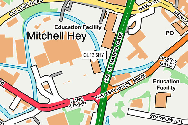
OL12 6HY is located in the Spotland & Falinge electoral ward, within the metropolitan district of Rochdale and the English Parliamentary constituency of Rochdale. The Sub Integrated Care Board (ICB) Location is NHS Greater Manchester ICB - 01D and the police force is Greater Manchester. This postcode has been in use since August 2010.


GetTheData
Source: OS OpenMap – Local (Ordnance Survey)
Source: OS VectorMap District (Ordnance Survey)
Licence: Open Government Licence (requires attribution)
| Easting | 389289 |
| Northing | 413238 |
| Latitude | 53.615577 |
| Longitude | -2.163384 |
GetTheData
Source: Open Postcode Geo
Licence: Open Government Licence
| Country | England |
| Postcode District | OL12 |
| ➜ OL12 open data dashboard ➜ See where OL12 is on a map ➜ Where is Rochdale? | |
GetTheData
Source: Land Registry Price Paid Data
Licence: Open Government Licence
Elevation or altitude of OL12 6HY as distance above sea level:
| Metres | Feet | |
|---|---|---|
| Elevation | 120m | 394ft |
Elevation is measured from the approximate centre of the postcode, to the nearest point on an OS contour line from OS Terrain 50, which has contour spacing of ten vertical metres.
➜ How high above sea level am I? Find the elevation of your current position using your device's GPS.
GetTheData
Source: Open Postcode Elevation
Licence: Open Government Licence
| Ward | Spotland & Falinge |
| Constituency | Rochdale |
GetTheData
Source: ONS Postcode Database
Licence: Open Government Licence
| Dane St/Manchester Rd (Dane St) | Rochdale | 124m |
| Dane St/Manchester Rd (Dane St) | Rochdale | 162m |
| College Rd/Holland St (College Rd) | Rochdale | 197m |
| Mellor St/Dane St (Mellor St) | Rochdale | 239m |
| Mellor St/Dane St (Mellor St) | Rochdale | 278m |
| Rochdale Interchange (Manchester Metrolink) (Smith Street) | Rochdale | 567m |
| Rochdale Railway Station (Manchester Metrolink) (Maclure Rd) | Rochdale | 780m |
| Rochdale Station | 0.9km |
| Castleton (Manchester) Station | 2.8km |
| Smithy Bridge Station | 3.8km |
GetTheData
Source: NaPTAN
Licence: Open Government Licence
GetTheData
Source: ONS Postcode Database
Licence: Open Government Licence


➜ Get more ratings from the Food Standards Agency
GetTheData
Source: Food Standards Agency
Licence: FSA terms & conditions
| Last Collection | |||
|---|---|---|---|
| Location | Mon-Fri | Sat | Distance |
| Collagebank | 17:45 | 11:00 | 160m |
| Rochdale Fpo | 18:30 | 12:00 | 304m |
| Packer Street | 19:00 | 319m | |
GetTheData
Source: Dracos
Licence: Creative Commons Attribution-ShareAlike
| Facility | Distance |
|---|---|
| Jd Gyms (Rochdale) Yorkshire Street, Rochdale Health and Fitness Gym, Studio | 484m |
| Castlemere Community Centre Tweedale Street, Rochdale Health and Fitness Gym, Sports Hall | 687m |
| Beech House School Manchester Road, Rochdale Sports Hall, Grass Pitches | 698m |
GetTheData
Source: Active Places
Licence: Open Government Licence
| School | Phase of Education | Distance |
|---|---|---|
| Rochdale Sixth Form College College Road, Rochdale, OL12 6HY | 16 plus | 183m |
| Broadfield Community Primary School Sparrow Hill, Rochdale, OL16 1QT | Primary | 237m |
| Beech House School 184 Manchester Road, Rochdale, OL11 4JQ | Not applicable | 707m |
GetTheData
Source: Edubase
Licence: Open Government Licence
| Risk of OL12 6HY flooding from rivers and sea | Medium |
| ➜ OL12 6HY flood map | |
GetTheData
Source: Open Flood Risk by Postcode
Licence: Open Government Licence
The below table lists the International Territorial Level (ITL) codes (formerly Nomenclature of Territorial Units for Statistics (NUTS) codes) and Local Administrative Units (LAU) codes for OL12 6HY:
| ITL 1 Code | Name |
|---|---|
| TLD | North West (England) |
| ITL 2 Code | Name |
| TLD3 | Greater Manchester |
| ITL 3 Code | Name |
| TLD37 | Greater Manchester North East |
| LAU 1 Code | Name |
| E08000005 | Rochdale |
GetTheData
Source: ONS Postcode Directory
Licence: Open Government Licence
The below table lists the Census Output Area (OA), Lower Layer Super Output Area (LSOA), and Middle Layer Super Output Area (MSOA) for OL12 6HY:
| Code | Name | |
|---|---|---|
| OA | E00027776 | |
| LSOA | E01005482 | Rochdale 010C |
| MSOA | E02001141 | Rochdale 010 |
GetTheData
Source: ONS Postcode Directory
Licence: Open Government Licence
| OL11 4HY | Manchester Road | 199m |
| OL12 6UG | Tentercroft | 256m |
| OL12 6UQ | Tentercroft | 256m |
| OL12 6UD | Underwood | 258m |
| OL12 6UH | Dunkirk Rise | 269m |
| OL12 6UJ | College Bank Way | 269m |
| OL16 1XB | Newgate | 275m |
| OL12 6XE | Fenwick Street | 279m |
| OL12 6XD | Mellor Street | 280m |
| OL12 6UL | Mitchell Hey | 281m |
GetTheData
Source: Open Postcode Geo; Land Registry Price Paid Data
Licence: Open Government Licence