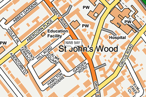
NW8 9AY is located in the Abbey Road electoral ward, within the London borough of Westminster and the English Parliamentary constituency of Westminster North. The Sub Integrated Care Board (ICB) Location is NHS North West London ICB - W2U3Z and the police force is Metropolitan Police. This postcode has been in use since January 1980.


GetTheData
Source: OS OpenMap – Local (Ordnance Survey)
Source: OS VectorMap District (Ordnance Survey)
Licence: Open Government Licence (requires attribution)
| Easting | 526478 |
| Northing | 183045 |
| Latitude | 51.532154 |
| Longitude | -0.177979 |
GetTheData
Source: Open Postcode Geo
Licence: Open Government Licence
| Country | England |
| Postcode District | NW8 |
| ➜ NW8 open data dashboard ➜ See where NW8 is on a map ➜ Where is City of Westminster? | |
GetTheData
Source: Land Registry Price Paid Data
Licence: Open Government Licence
Elevation or altitude of NW8 9AY as distance above sea level:
| Metres | Feet | |
|---|---|---|
| Elevation | 40m | 131ft |
Elevation is measured from the approximate centre of the postcode, to the nearest point on an OS contour line from OS Terrain 50, which has contour spacing of ten vertical metres.
➜ How high above sea level am I? Find the elevation of your current position using your device's GPS.
GetTheData
Source: Open Postcode Elevation
Licence: Open Government Licence
| Ward | Abbey Road |
| Constituency | Westminster North |
GetTheData
Source: ONS Postcode Database
Licence: Open Government Licence
| January 2024 | Violence and sexual offences | On or near Langford Close | 292m |
| December 2023 | Vehicle crime | On or near Finchley Place | 378m |
| November 2023 | Violence and sexual offences | On or near Regents Mews | 212m |
| ➜ Get more crime data in our Crime section | |||
GetTheData
Source: data.police.uk
Licence: Open Government Licence
| Abbey Road Studios Grove End Road (Abbey Road) | Maida Vale | 34m |
| Hall Road (Grove End Road) | Maida Vale | 134m |
| Grove End Road | Maida Vale | 200m |
| Grove End Road | Maida Vale | 229m |
| Hall Road | Maida Vale | 260m |
| St. John's Wood Underground Station | St Johns Wood | 384m |
| Maida Vale Underground Station | Maida Vale | 601m |
| Warwick Avenue Underground Station | Warwick Avenue | 1,068m |
| Kilburn Park Underground Station | Kilburn Park | 1,170m |
| Swiss Cottage Underground Station | Swiss Cottage | 1,300m |
| South Hampstead Station | 1km |
| Kilburn High Road Station | 1.1km |
| London Marylebone Station | 1.5km |
GetTheData
Source: NaPTAN
Licence: Open Government Licence
GetTheData
Source: ONS Postcode Database
Licence: Open Government Licence


➜ Get more ratings from the Food Standards Agency
GetTheData
Source: Food Standards Agency
Licence: FSA terms & conditions
| Last Collection | |||
|---|---|---|---|
| Location | Mon-Fri | Sat | Distance |
| Abercorn Place | 17:30 | 12:00 | 152m |
| Hall Road | 17:30 | 12:00 | 193m |
| Nugent Terrace | 17:30 | 12:00 | 194m |
GetTheData
Source: Dracos
Licence: Creative Commons Attribution-ShareAlike
| Facility | Distance |
|---|---|
| American School In London Waverley Place, London Health and Fitness Gym, Swimming Pool | 307m |
| Marylebone Cricket Club (Lords Cricket Ground) St. Johns Wood Road, London Health and Fitness Gym, Grass Pitches, Sports Hall, Squash Courts | 469m |
| St Josephs Catholic Primary School (Hampstead) Lanark Road, London Artificial Grass Pitch | 604m |
GetTheData
Source: Active Places
Licence: Open Government Licence
| School | Phase of Education | Distance |
|---|---|---|
| Abercorn School 28 Abercorn Place, London, NW8 9XP | Not applicable | 137m |
| Arnold House School 1-3 Loudoun Road, St John's Wood, London, NW8 0LH | Not applicable | 217m |
| The American School in London 1 Waverley Place, London, NW8 0NP | Not applicable | 308m |
GetTheData
Source: Edubase
Licence: Open Government Licence
The below table lists the International Territorial Level (ITL) codes (formerly Nomenclature of Territorial Units for Statistics (NUTS) codes) and Local Administrative Units (LAU) codes for NW8 9AY:
| ITL 1 Code | Name |
|---|---|
| TLI | London |
| ITL 2 Code | Name |
| TLI3 | Inner London - West |
| ITL 3 Code | Name |
| TLI32 | Westminster |
| LAU 1 Code | Name |
| E09000033 | Westminster |
GetTheData
Source: ONS Postcode Directory
Licence: Open Government Licence
The below table lists the Census Output Area (OA), Lower Layer Super Output Area (LSOA), and Middle Layer Super Output Area (MSOA) for NW8 9AY:
| Code | Name | |
|---|---|---|
| OA | E00023424 | |
| LSOA | E01004651 | Westminster 003A |
| MSOA | E02000962 | Westminster 003 |
GetTheData
Source: ONS Postcode Directory
Licence: Open Government Licence
| NW8 9AA | Abbey Road | 28m |
| NW8 9BT | Abbey Road | 28m |
| NW8 9BU | Abbey Road | 28m |
| NW8 9BX | Abbey Road | 28m |
| NW8 9AB | Abbey Road | 47m |
| NW8 9AD | Abbey Road | 47m |
| NW8 9DD | Abbey Road | 54m |
| NW8 9QE | Hill Road | 70m |
| NW8 9BY | Garden Road | 70m |
| NW8 9DA | Abbey Road | 72m |
GetTheData
Source: Open Postcode Geo; Land Registry Price Paid Data
Licence: Open Government Licence