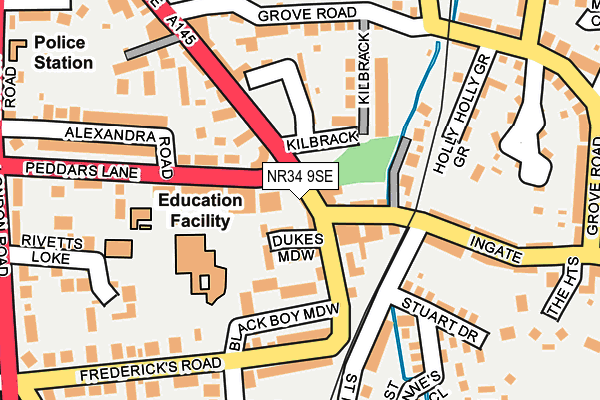
NR34 9SE is located in the Beccles & Worlingham electoral ward, within the local authority district of East Suffolk and the English Parliamentary constituency of Waveney. The Sub Integrated Care Board (ICB) Location is NHS Norfolk and Waveney ICB - 26A and the police force is Suffolk. This postcode has been in use since January 1980.


GetTheData
Source: OS OpenMap – Local (Ordnance Survey)
Source: OS VectorMap District (Ordnance Survey)
Licence: Open Government Licence (requires attribution)
| Easting | 642577 |
| Northing | 289937 |
| Latitude | 52.453503 |
| Longitude | 1.568774 |
GetTheData
Source: Open Postcode Geo
Licence: Open Government Licence
| Country | England |
| Postcode District | NR34 |
| ➜ NR34 open data dashboard ➜ See where NR34 is on a map ➜ Where is Beccles? | |
GetTheData
Source: Land Registry Price Paid Data
Licence: Open Government Licence
Elevation or altitude of NR34 9SE as distance above sea level:
| Metres | Feet | |
|---|---|---|
| Elevation | 10m | 33ft |
Elevation is measured from the approximate centre of the postcode, to the nearest point on an OS contour line from OS Terrain 50, which has contour spacing of ten vertical metres.
➜ How high above sea level am I? Find the elevation of your current position using your device's GPS.
GetTheData
Source: Open Postcode Elevation
Licence: Open Government Licence
| Ward | Beccles & Worlingham |
| Constituency | Waveney |
GetTheData
Source: ONS Postcode Database
Licence: Open Government Licence
| December 2023 | Other theft | On or near Petrol Station | 333m |
| November 2023 | Other theft | On or near Petrol Station | 333m |
| October 2023 | Violence and sexual offences | On or near St Anne'S Close | 212m |
| ➜ Get more crime data in our Crime section | |||
GetTheData
Source: data.police.uk
Licence: Open Government Licence
| Eileen Crisp Court (Blyburgate) | Beccles | 94m |
| Eileen Crisp Court (Blyburgate) | Beccles | 100m |
| Stuart Drive (St Annes Road) | Beccles | 123m |
| Stuart Drive (St Annes Road) | Beccles | 131m |
| Alexandra Road (Peddars Lane) | Beccles | 169m |
| Beccles Station | 0.6km |
GetTheData
Source: NaPTAN
Licence: Open Government Licence
| Percentage of properties with Next Generation Access | 100.0% |
| Percentage of properties with Superfast Broadband | 100.0% |
| Percentage of properties with Ultrafast Broadband | 0.0% |
| Percentage of properties with Full Fibre Broadband | 0.0% |
Superfast Broadband is between 30Mbps and 300Mbps
Ultrafast Broadband is > 300Mbps
| Percentage of properties unable to receive 2Mbps | 0.0% |
| Percentage of properties unable to receive 5Mbps | 0.0% |
| Percentage of properties unable to receive 10Mbps | 0.0% |
| Percentage of properties unable to receive 30Mbps | 0.0% |
GetTheData
Source: Ofcom
Licence: Ofcom Terms of Use (requires attribution)
GetTheData
Source: ONS Postcode Database
Licence: Open Government Licence


➜ Get more ratings from the Food Standards Agency
GetTheData
Source: Food Standards Agency
Licence: FSA terms & conditions
| Last Collection | |||
|---|---|---|---|
| Location | Mon-Fri | Sat | Distance |
| Old Market | 17:30 | 12:00 | 744m |
| The Street Post Office | 16:00 | 08:30 | 1,302m |
| Townlands Drive | 17:30 | 12:00 | 1,504m |
GetTheData
Source: Dracos
Licence: Creative Commons Attribution-ShareAlike
| Facility | Distance |
|---|---|
| Set Beccles School Castle Hill, Beccles Grass Pitches, Sports Hall | 425m |
| Beccles Indoor Bowls Club Common Lane, Beccles Indoor Bowls | 467m |
| Beef Meadow Common Lane, Beccles Grass Pitches | 523m |
GetTheData
Source: Active Places
Licence: Open Government Licence
| School | Phase of Education | Distance |
|---|---|---|
| The Albert Pye Community Primary School Frederick's Road, Beccles, NR34 9UL | Primary | 174m |
| Set Beccles School Castle Hill, Beccles, NR34 7BQ | Secondary | 425m |
| St Benet's Catholic Primary School Ringsfield Road, Beccles, NR34 9PQ | Primary | 688m |
GetTheData
Source: Edubase
Licence: Open Government Licence
| Risk of NR34 9SE flooding from rivers and sea | Medium |
| ➜ NR34 9SE flood map | |
GetTheData
Source: Open Flood Risk by Postcode
Licence: Open Government Licence
The below table lists the International Territorial Level (ITL) codes (formerly Nomenclature of Territorial Units for Statistics (NUTS) codes) and Local Administrative Units (LAU) codes for NR34 9SE:
| ITL 1 Code | Name |
|---|---|
| TLH | East |
| ITL 2 Code | Name |
| TLH1 | East Anglia |
| ITL 3 Code | Name |
| TLH14 | Suffolk CC |
| LAU 1 Code | Name |
| E07000244 | East Suffolk |
GetTheData
Source: ONS Postcode Directory
Licence: Open Government Licence
The below table lists the Census Output Area (OA), Lower Layer Super Output Area (LSOA), and Middle Layer Super Output Area (MSOA) for NR34 9SE:
| Code | Name | |
|---|---|---|
| OA | E00154140 | |
| LSOA | E01030223 | Waveney 010A |
| MSOA | E02006311 | Waveney 010 |
GetTheData
Source: ONS Postcode Directory
Licence: Open Government Licence
| NR34 9RU | Ingate | 31m |
| NR34 9ET | Dukes Meadow | 84m |
| NR34 9TD | Eileen Crisp Court | 87m |
| NR34 9SS | Laurels End | 95m |
| NR34 9SA | St Annes Road | 97m |
| NR34 9SH | Kilbrack | 105m |
| NR34 9UH | Peddars Lane | 116m |
| NR34 9UQ | Black Boy Meadow | 120m |
| NR34 9SG | Holly Grove | 143m |
| NR34 9UG | Fredericks Road | 155m |
GetTheData
Source: Open Postcode Geo; Land Registry Price Paid Data
Licence: Open Government Licence