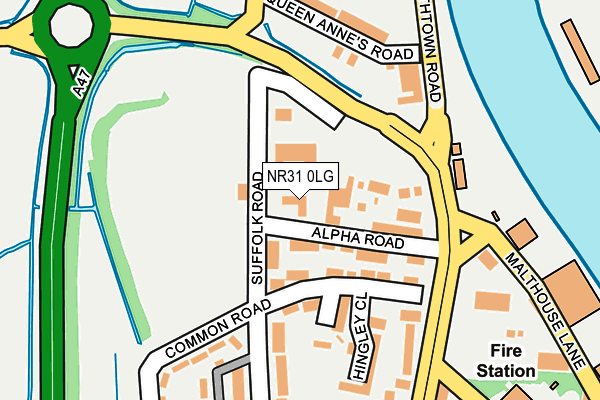
NR31 0LG lies on Valentine Cottages in Great Yarmouth. NR31 0LG is located in the Claydon electoral ward, within the local authority district of Great Yarmouth and the English Parliamentary constituency of Great Yarmouth. The Sub Integrated Care Board (ICB) Location is NHS Norfolk and Waveney ICB - 26A and the police force is Norfolk. This postcode has been in use since January 1980.


GetTheData
Source: OS OpenMap – Local (Ordnance Survey)
Source: OS VectorMap District (Ordnance Survey)
Licence: Open Government Licence (requires attribution)
| Easting | 652280 |
| Northing | 305713 |
| Latitude | 52.590615 |
| Longitude | 1.723194 |
GetTheData
Source: Open Postcode Geo
Licence: Open Government Licence
| Street | Valentine Cottages |
| Town/City | Great Yarmouth |
| Country | England |
| Postcode District | NR31 |
| ➜ NR31 open data dashboard ➜ See where NR31 is on a map ➜ Where is Great Yarmouth? | |
GetTheData
Source: Land Registry Price Paid Data
Licence: Open Government Licence
Elevation or altitude of NR31 0LG as distance above sea level:
| Metres | Feet | |
|---|---|---|
| Elevation | 0m | 0ft |
Elevation is measured from the approximate centre of the postcode, to the nearest point on an OS contour line from OS Terrain 50, which has contour spacing of ten vertical metres.
➜ How high above sea level am I? Find the elevation of your current position using your device's GPS.
GetTheData
Source: Open Postcode Elevation
Licence: Open Government Licence
| Ward | Claydon |
| Constituency | Great Yarmouth |
GetTheData
Source: ONS Postcode Database
Licence: Open Government Licence
| January 2024 | Anti-social behaviour | On or near Hingley Close | 147m |
| November 2023 | Theft from the person | On or near Hingley Close | 147m |
| June 2023 | Violence and sexual offences | On or near Hingley Close | 147m |
| ➜ Get more crime data in our Crime section | |||
GetTheData
Source: data.police.uk
Licence: Open Government Licence
| Alpha Road (Beccles Road) | Gorleston | 163m |
| Alpha Road (Beccles Road) | Gorleston | 165m |
| Waveney Road (Southtown Road) | Great Yarmouth | 333m |
| Manby Road (Beccles Road) | Gorleston | 348m |
| Ferry Side (High Road) | Gorleston | 351m |
| Great Yarmouth Station | 2.4km |
GetTheData
Source: NaPTAN
Licence: Open Government Licence
GetTheData
Source: ONS Postcode Database
Licence: Open Government Licence


➜ Get more ratings from the Food Standards Agency
GetTheData
Source: Food Standards Agency
Licence: FSA terms & conditions
| Last Collection | |||
|---|---|---|---|
| Location | Mon-Fri | Sat | Distance |
| Suffolk Walk | 17:30 | 12:00 | 433m |
| Southtown Road | 17:00 | 12:00 | 528m |
| Boundary Road | 17:30 | 12:30 | 537m |
GetTheData
Source: Dracos
Licence: Creative Commons Attribution-ShareAlike
| Facility | Distance |
|---|---|
| Southtown Common Suffolk Road, Gorleston, Great Yarmouth Grass Pitches | 128m |
| Bwell Gym Bessemer Way, Great Yarmouth Health and Fitness Gym, Studio | 674m |
| Harfries Fitness Centre (Closed) Bessemer Way, Great Yarmouth Studio, Health and Fitness Gym | 697m |
GetTheData
Source: Active Places
Licence: Open Government Licence
| School | Phase of Education | Distance |
|---|---|---|
| Wroughton Infant Academy Beccles Road, Gorleston, Great Yarmouth, NR31 8AH | Primary | 770m |
| Wroughton Junior Academy Burgh Road, Gorleston, Great Yarmouth, NR31 8BD | Primary | 770m |
| Great Yarmouth Primary Academy Dickens Avenue, Great Yarmouth, NR30 3DT | Primary | 863m |
GetTheData
Source: Edubase
Licence: Open Government Licence
| Risk of NR31 0LG flooding from rivers and sea | Very Low |
| ➜ NR31 0LG flood map | |
GetTheData
Source: Open Flood Risk by Postcode
Licence: Open Government Licence
The below table lists the International Territorial Level (ITL) codes (formerly Nomenclature of Territorial Units for Statistics (NUTS) codes) and Local Administrative Units (LAU) codes for NR31 0LG:
| ITL 1 Code | Name |
|---|---|
| TLH | East |
| ITL 2 Code | Name |
| TLH1 | East Anglia |
| ITL 3 Code | Name |
| TLH15 | Norwich and East Norfolk |
| LAU 1 Code | Name |
| E07000145 | Great Yarmouth |
GetTheData
Source: ONS Postcode Directory
Licence: Open Government Licence
The below table lists the Census Output Area (OA), Lower Layer Super Output Area (LSOA), and Middle Layer Super Output Area (MSOA) for NR31 0LG:
| Code | Name | |
|---|---|---|
| OA | E00135191 | |
| LSOA | E01026600 | Great Yarmouth 007A |
| MSOA | E02005544 | Great Yarmouth 007 |
GetTheData
Source: ONS Postcode Directory
Licence: Open Government Licence
| NR31 0LQ | Alpha Road | 87m |
| NR31 0QG | Common Road | 88m |
| NR31 0QQ | Excelsior Terrace | 114m |
| NR31 0LF | Southtown Road | 163m |
| NR31 0PT | Beccles Road | 177m |
| NR31 0QH | Hingley Close | 181m |
| NR31 0QB | Suffolk Road | 183m |
| NR31 0LE | Queen Annes Road | 190m |
| NR31 0QA | Manor Road | 223m |
| NR31 0QF | Common Road | 249m |
GetTheData
Source: Open Postcode Geo; Land Registry Price Paid Data
Licence: Open Government Licence