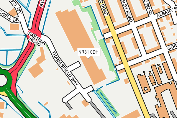
NR31 0DH is located in the Southtown and Cobholm electoral ward, within the local authority district of Great Yarmouth and the English Parliamentary constituency of Great Yarmouth. The Sub Integrated Care Board (ICB) Location is NHS Norfolk and Waveney ICB - 26A and the police force is Norfolk. This postcode has been in use since October 2004.


GetTheData
Source: OS OpenMap – Local (Ordnance Survey)
Source: OS VectorMap District (Ordnance Survey)
Licence: Open Government Licence (requires attribution)
| Easting | 651872 |
| Northing | 306654 |
| Latitude | 52.599246 |
| Longitude | 1.717900 |
GetTheData
Source: Open Postcode Geo
Licence: Open Government Licence
| Country | England |
| Postcode District | NR31 |
| ➜ NR31 open data dashboard ➜ See where NR31 is on a map ➜ Where is Great Yarmouth? | |
GetTheData
Source: Land Registry Price Paid Data
Licence: Open Government Licence
Elevation or altitude of NR31 0DH as distance above sea level:
| Metres | Feet | |
|---|---|---|
| Elevation | 0m | 0ft |
Elevation is measured from the approximate centre of the postcode, to the nearest point on an OS contour line from OS Terrain 50, which has contour spacing of ten vertical metres.
➜ How high above sea level am I? Find the elevation of your current position using your device's GPS.
GetTheData
Source: Open Postcode Elevation
Licence: Open Government Licence
| Ward | Southtown And Cobholm |
| Constituency | Great Yarmouth |
GetTheData
Source: ONS Postcode Database
Licence: Open Government Licence
| June 2022 | Violence and sexual offences | On or near Thamesfield Way | 91m |
| June 2022 | Burglary | On or near Stafford Road | 162m |
| June 2022 | Burglary | On or near Stafford Road | 162m |
| ➜ Get more crime data in our Crime section | |||
GetTheData
Source: data.police.uk
Licence: Open Government Licence
| Suffolk Road | Great Yarmouth | 269m |
| Retail Park (Gapton Hall Road) | Great Yarmouth | 370m |
| Retail Park (Gapton Hall Road) | Great Yarmouth | 388m |
| Gordon Road (Southdown Road) | Great Yarmouth | 395m |
| Tesco Petrol Station (Jones (Gc) Way) | Cobholm | 421m |
| Great Yarmouth Station | 1.5km |
GetTheData
Source: NaPTAN
Licence: Open Government Licence
GetTheData
Source: ONS Postcode Database
Licence: Open Government Licence


➜ Get more ratings from the Food Standards Agency
GetTheData
Source: Food Standards Agency
Licence: FSA terms & conditions
| Last Collection | |||
|---|---|---|---|
| Location | Mon-Fri | Sat | Distance |
| Lichfield Road Post Office | 17:30 | 12:15 | 307m |
| Tesco, Pasteur Road | 17:00 | 12:00 | 505m |
| Boundary Road | 17:30 | 12:30 | 642m |
GetTheData
Source: Dracos
Licence: Creative Commons Attribution-ShareAlike
| Facility | Distance |
|---|---|
| Puregym (Great Yarmouth) Pasteur Retail Park, Thamesfield Way, Great Yarmouth Health and Fitness Gym | 66m |
| East Coast College Sport And Wellbeing Centre Lichfield Road, Great Yarmouth Sports Hall, Health and Fitness Gym, Studio | 310m |
| Nr Health And Fitness (Great Yarmouth) Southtown Road, Great Yarmouth Health and Fitness Gym, Studio | 330m |
GetTheData
Source: Active Places
Licence: Open Government Licence
| School | Phase of Education | Distance |
|---|---|---|
| Edward Worlledge Ormiston Academy Suffolk Road, Great Yarmouth, NR31 0ER | Primary | 218m |
| Southtown Primary School Tamworth Lane, Southtown, Great Yarmouth, NR31 0HJ | Primary | 282m |
| Cobholm Primary Academy Mill Road, Cobholm, Great Yarmouth, NR31 0BA | Primary | 1km |
GetTheData
Source: Edubase
Licence: Open Government Licence
| Risk of NR31 0DH flooding from rivers and sea | Very Low |
| ➜ NR31 0DH flood map | |
GetTheData
Source: Open Flood Risk by Postcode
Licence: Open Government Licence
The below table lists the International Territorial Level (ITL) codes (formerly Nomenclature of Territorial Units for Statistics (NUTS) codes) and Local Administrative Units (LAU) codes for NR31 0DH:
| ITL 1 Code | Name |
|---|---|
| TLH | East |
| ITL 2 Code | Name |
| TLH1 | East Anglia |
| ITL 3 Code | Name |
| TLH15 | Norwich and East Norfolk |
| LAU 1 Code | Name |
| E07000145 | Great Yarmouth |
GetTheData
Source: ONS Postcode Directory
Licence: Open Government Licence
The below table lists the Census Output Area (OA), Lower Layer Super Output Area (LSOA), and Middle Layer Super Output Area (MSOA) for NR31 0DH:
| Code | Name | |
|---|---|---|
| OA | E00135345 | |
| LSOA | E01026633 | Great Yarmouth 007B |
| MSOA | E02005544 | Great Yarmouth 007 |
GetTheData
Source: ONS Postcode Directory
Licence: Open Government Licence
| NR31 0ES | Stafford Road | 100m |
| NR31 0EP | Gordon Road | 108m |
| NR31 0ET | Albany Road | 111m |
| NR31 0EN | Wolseley Road | 161m |
| NR31 0EX | Stafford Road | 165m |
| NR31 0EW | Gordon Road | 168m |
| NR31 0EU | Albany Road | 183m |
| NR31 0EZ | Anson Road | 211m |
| NR31 0EL | Wolseley Road | 229m |
| NR31 0BJ | Limetree Court | 273m |
GetTheData
Source: Open Postcode Geo; Land Registry Price Paid Data
Licence: Open Government Licence