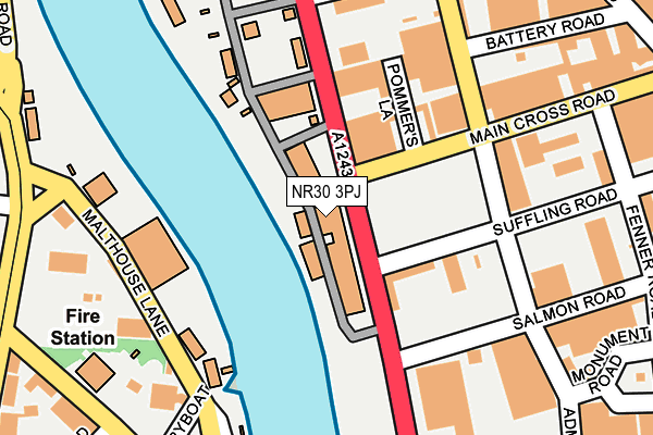
NR30 3PJ is located in the Nelson electoral ward, within the local authority district of Great Yarmouth and the English Parliamentary constituency of Great Yarmouth. The Sub Integrated Care Board (ICB) Location is NHS Norfolk and Waveney ICB - 26A and the police force is Norfolk. This postcode has been in use since February 1990.


GetTheData
Source: OS OpenMap – Local (Ordnance Survey)
Source: OS VectorMap District (Ordnance Survey)
Licence: Open Government Licence (requires attribution)
| Easting | 652710 |
| Northing | 305653 |
| Latitude | 52.589877 |
| Longitude | 1.729482 |
GetTheData
Source: Open Postcode Geo
Licence: Open Government Licence
| Country | England |
| Postcode District | NR30 |
| ➜ NR30 open data dashboard ➜ See where NR30 is on a map ➜ Where is Great Yarmouth? | |
GetTheData
Source: Land Registry Price Paid Data
Licence: Open Government Licence
Elevation or altitude of NR30 3PJ as distance above sea level:
| Metres | Feet | |
|---|---|---|
| Elevation | 0m | 0ft |
Elevation is measured from the approximate centre of the postcode, to the nearest point on an OS contour line from OS Terrain 50, which has contour spacing of ten vertical metres.
➜ How high above sea level am I? Find the elevation of your current position using your device's GPS.
GetTheData
Source: Open Postcode Elevation
Licence: Open Government Licence
| Ward | Nelson |
| Constituency | Great Yarmouth |
GetTheData
Source: ONS Postcode Database
Licence: Open Government Licence
| January 2024 | Anti-social behaviour | On or near Hingley Close | 375m |
| November 2023 | Theft from the person | On or near Hingley Close | 375m |
| June 2023 | Violence and sexual offences | On or near Hingley Close | 375m |
| ➜ Get more crime data in our Crime section | |||
GetTheData
Source: data.police.uk
Licence: Open Government Licence
| Battery Road (Admiralty Road) | Great Yarmouth | 167m |
| Ferry Side (High Road) | Gorleston | 269m |
| Alpha Road (Beccles Road) | Gorleston | 269m |
| Highfield Road (High Road) | Gorleston | 279m |
| Alpha Road (Beccles Road) | Gorleston | 305m |
| Great Yarmouth Station | 2.5km |
GetTheData
Source: NaPTAN
Licence: Open Government Licence
GetTheData
Source: ONS Postcode Database
Licence: Open Government Licence


➜ Get more ratings from the Food Standards Agency
GetTheData
Source: Food Standards Agency
Licence: FSA terms & conditions
| Last Collection | |||
|---|---|---|---|
| Location | Mon-Fri | Sat | Distance |
| Beevor Road | 18:30 | 12:00 | 349m |
| Addison Road | 15:00 | 12:00 | 548m |
| Suffolk Walk | 17:30 | 12:00 | 568m |
GetTheData
Source: Dracos
Licence: Creative Commons Attribution-ShareAlike
| Facility | Distance |
|---|---|
| Southtown Common Suffolk Road, Gorleston, Great Yarmouth Grass Pitches | 562m |
| Body Generation Gym Southgates Road, Great Yarmouth Health and Fitness Gym | 712m |
| St Nicholas Recreation Ground Marine Parade, Great Yarmouth Grass Pitches | 810m |
GetTheData
Source: Active Places
Licence: Open Government Licence
| School | Phase of Education | Distance |
|---|---|---|
| Great Yarmouth Primary Academy Dickens Avenue, Great Yarmouth, NR30 3DT | Primary | 645m |
| St Mary and St Peter Catholic Primary School East Anglian Way, Gorleston, Great Yarmouth, NR31 6QY | Primary | 942m |
| Wroughton Infant Academy Beccles Road, Gorleston, Great Yarmouth, NR31 8AH | Primary | 997m |
GetTheData
Source: Edubase
Licence: Open Government Licence
| Risk of NR30 3PJ flooding from rivers and sea | Medium |
| ➜ NR30 3PJ flood map | |
GetTheData
Source: Open Flood Risk by Postcode
Licence: Open Government Licence
The below table lists the International Territorial Level (ITL) codes (formerly Nomenclature of Territorial Units for Statistics (NUTS) codes) and Local Administrative Units (LAU) codes for NR30 3PJ:
| ITL 1 Code | Name |
|---|---|
| TLH | East |
| ITL 2 Code | Name |
| TLH1 | East Anglia |
| ITL 3 Code | Name |
| TLH15 | Norwich and East Norfolk |
| LAU 1 Code | Name |
| E07000145 | Great Yarmouth |
GetTheData
Source: ONS Postcode Directory
Licence: Open Government Licence
The below table lists the Census Output Area (OA), Lower Layer Super Output Area (LSOA), and Middle Layer Super Output Area (MSOA) for NR30 3PJ:
| Code | Name | |
|---|---|---|
| OA | E00135303 | |
| LSOA | E01026622 | Great Yarmouth 006A |
| MSOA | E02005543 | Great Yarmouth 006 |
GetTheData
Source: ONS Postcode Directory
Licence: Open Government Licence
| NR30 3PU | Admiralty Road | 244m |
| NR30 3NZ | Main Cross Road | 282m |
| NR31 0PD | Ferry Hill | 286m |
| NR31 0PJ | High Road | 290m |
| NR30 3NQ | Swanstons Road | 291m |
| NR31 0PE | High Road | 303m |
| NR31 0PT | Beccles Road | 328m |
| NR31 0PP | Highfield Road | 342m |
| NR31 0LQ | Alpha Road | 350m |
| NR31 0PF | Burnt Lane | 355m |
GetTheData
Source: Open Postcode Geo; Land Registry Price Paid Data
Licence: Open Government Licence