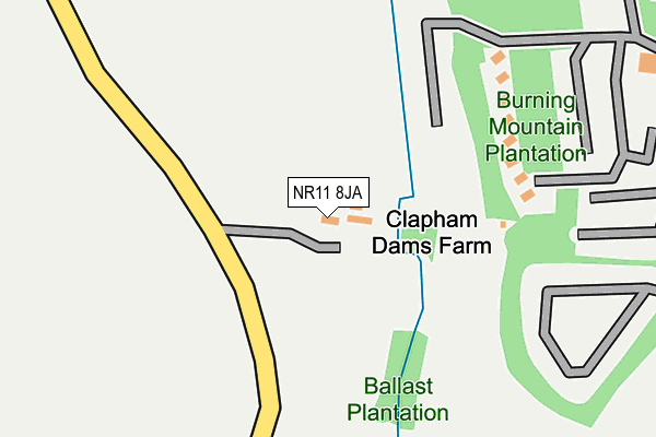
NR11 8JA is located in the Roughton electoral ward, within the local authority district of North Norfolk and the English Parliamentary constituency of North Norfolk. The Sub Integrated Care Board (ICB) Location is NHS Norfolk and Waveney ICB - 26A and the police force is Norfolk. This postcode has been in use since January 1980.


GetTheData
Source: OS OpenMap – Local (Ordnance Survey)
Source: OS VectorMap District (Ordnance Survey)
Licence: Open Government Licence (requires attribution)
| Easting | 626783 |
| Northing | 338348 |
| Latitude | 52.894712 |
| Longitude | 1.370043 |
GetTheData
Source: Open Postcode Geo
Licence: Open Government Licence
| Country | England |
| Postcode District | NR11 |
| ➜ NR11 open data dashboard ➜ See where NR11 is on a map | |
GetTheData
Source: Land Registry Price Paid Data
Licence: Open Government Licence
Elevation or altitude of NR11 8JA as distance above sea level:
| Metres | Feet | |
|---|---|---|
| Elevation | 40m | 131ft |
Elevation is measured from the approximate centre of the postcode, to the nearest point on an OS contour line from OS Terrain 50, which has contour spacing of ten vertical metres.
➜ How high above sea level am I? Find the elevation of your current position using your device's GPS.
GetTheData
Source: Open Postcode Elevation
Licence: Open Government Licence
| Ward | Roughton |
| Constituency | North Norfolk |
GetTheData
Source: ONS Postcode Database
Licence: Open Government Licence
| Staden Park (Church Street) | Trimingham | 865m |
| Staden Park (Church Street) | Trimingham | 873m |
| Houses (Cromer Road) | Sidestrand | 1,315m |
| Broadwood Close (Church Street) | Trimingham | 1,345m |
| Broadwood Close (Church Street) | Trimingham | 1,364m |
| Gunton Station | 3.5km |
| Roughton Road Station | 5.4km |
GetTheData
Source: NaPTAN
Licence: Open Government Licence
GetTheData
Source: ONS Postcode Database
Licence: Open Government Licence


➜ Get more ratings from the Food Standards Agency
GetTheData
Source: Food Standards Agency
Licence: FSA terms & conditions
| Last Collection | |||
|---|---|---|---|
| Location | Mon-Fri | Sat | Distance |
| Templewood | 16:00 | 08:30 | 1,405m |
| The Rectory | 16:00 | 08:30 | 1,912m |
| High Street Post Office | 16:30 | 10:00 | 2,123m |
GetTheData
Source: Dracos
Licence: Creative Commons Attribution-ShareAlike
| Facility | Distance |
|---|---|
| Woodland Holiday Park Cromer Road, Trimingham, Norwich Swimming Pool, Outdoor Tennis Courts, Health and Fitness Gym | 291m |
| Sidestrand Hall School Cromer Road, Sidestrand, Cromer Grass Pitches, Sports Hall | 1.8km |
| Southrepps Playing Field Chapel Street, Chapel Street, Southrepps Grass Pitches | 2.2km |
GetTheData
Source: Active Places
Licence: Open Government Licence
| School | Phase of Education | Distance |
|---|---|---|
| Sidestrand Hall School Cromer Road, Sidestrand, Cromer, NR27 0NH | Not applicable | 1.7km |
| Northrepps Primary School Church Street, Northrepps, Cromer, NR27 0LG | Primary | 2.5km |
| Overstrand, the Belfry, Church of England Voluntary Aided Primary School 23 Cromer Road, Overstrand, Cromer, NR27 0NT | Primary | 3.4km |
GetTheData
Source: Edubase
Licence: Open Government Licence
The below table lists the International Territorial Level (ITL) codes (formerly Nomenclature of Territorial Units for Statistics (NUTS) codes) and Local Administrative Units (LAU) codes for NR11 8JA:
| ITL 1 Code | Name |
|---|---|
| TLH | East |
| ITL 2 Code | Name |
| TLH1 | East Anglia |
| ITL 3 Code | Name |
| TLH16 | North and West Norfolk |
| LAU 1 Code | Name |
| E07000147 | North Norfolk |
GetTheData
Source: ONS Postcode Directory
Licence: Open Government Licence
The below table lists the Census Output Area (OA), Lower Layer Super Output Area (LSOA), and Middle Layer Super Output Area (MSOA) for NR11 8JA:
| Code | Name | |
|---|---|---|
| OA | E00136092 | |
| LSOA | E01026766 | North Norfolk 005B |
| MSOA | E02005574 | North Norfolk 005 |
GetTheData
Source: ONS Postcode Directory
Licence: Open Government Licence
| NR11 8XB | Top Road | 581m |
| NR11 8HY | Cromer Road | 703m |
| NR11 8HZ | Cromer Road | 711m |
| NR11 8HX | Staden Park | 823m |
| NR11 8HU | Cromer Road | 868m |
| NR27 0LS | Main Road | 887m |
| NR11 8HT | Cromer Road | 939m |
| NR11 8BF | Church Road | 1123m |
| NR11 8AL | Church Street | 1132m |
| NR11 8EQ | Loop Road | 1154m |
GetTheData
Source: Open Postcode Geo; Land Registry Price Paid Data
Licence: Open Government Licence