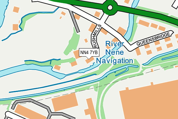
NN4 7YB lies on Rushmills in Northampton. NN4 7YB is located in the Nene Valley electoral ward, within the unitary authority of West Northamptonshire and the English Parliamentary constituency of South Northamptonshire. The Sub Integrated Care Board (ICB) Location is NHS Northamptonshire ICB - 78H and the police force is Northamptonshire. This postcode has been in use since August 1993.


GetTheData
Source: OS OpenMap – Local (Ordnance Survey)
Source: OS VectorMap District (Ordnance Survey)
Licence: Open Government Licence (requires attribution)
| Easting | 477772 |
| Northing | 259494 |
| Latitude | 52.228180 |
| Longitude | -0.862753 |
GetTheData
Source: Open Postcode Geo
Licence: Open Government Licence
| Street | Rushmills |
| Town/City | Northampton |
| Country | England |
| Postcode District | NN4 |
| ➜ NN4 open data dashboard ➜ See where NN4 is on a map ➜ Where is Northampton? | |
GetTheData
Source: Land Registry Price Paid Data
Licence: Open Government Licence
Elevation or altitude of NN4 7YB as distance above sea level:
| Metres | Feet | |
|---|---|---|
| Elevation | 60m | 197ft |
Elevation is measured from the approximate centre of the postcode, to the nearest point on an OS contour line from OS Terrain 50, which has contour spacing of ten vertical metres.
➜ How high above sea level am I? Find the elevation of your current position using your device's GPS.
GetTheData
Source: Open Postcode Elevation
Licence: Open Government Licence
| Ward | Nene Valley |
| Constituency | South Northamptonshire |
GetTheData
Source: ONS Postcode Database
Licence: Open Government Licence
BRITANNIA HOUSE, RUSHMILLS, NORTHAMPTON, NN4 7YB 2018 1 NOV £480,000 |
1, RUSHMILLS, NORTHAMPTON, NN4 7YB 2018 29 JAN £1,375,000 |
GetTheData
Source: HM Land Registry Price Paid Data
Licence: Contains HM Land Registry data © Crown copyright and database right 2024. This data is licensed under the Open Government Licence v3.0.
| June 2022 | Anti-social behaviour | On or near Queensbridge | 166m |
| June 2022 | Anti-social behaviour | On or near Waterside Way | 189m |
| June 2022 | Violence and sexual offences | On or near Queensbridge | 215m |
| ➜ Rushmills crime map and outcomes | |||
GetTheData
Source: data.police.uk
Licence: Open Government Licence
| Footpath To The Lakes (Bedford Road) | Brackmills | 135m |
| Holiday Inn (Bedford Road) | Brackmills | 191m |
| Footpath To The Lakes (Bedford Road) | Brackmills | 227m |
| Holiday Inn (Bedford Road) | Brackmills | 243m |
| County Council Offices (The Lakes) | Brackmills | 441m |
| Northampton Station | 3.2km |
GetTheData
Source: NaPTAN
Licence: Open Government Licence
GetTheData
Source: ONS Postcode Database
Licence: Open Government Licence


➜ Get more ratings from the Food Standards Agency
GetTheData
Source: Food Standards Agency
Licence: FSA terms & conditions
| Last Collection | |||
|---|---|---|---|
| Location | Mon-Fri | Sat | Distance |
| Liliput Road | 18:30 | 11:30 | 613m |
| Liliput Road | 18:30 | 615m | |
| Kilvey Road | 18:30 | 11:30 | 817m |
GetTheData
Source: Dracos
Licence: Creative Commons Attribution-ShareAlike
| Facility | Distance |
|---|---|
| Northampton Casuals Rfc Old Bedford Road, Northampton Grass Pitches | 97m |
| Blood Sweat And Tears Mma Academy (Closed) Osyth Close, Brackmills Industrial Estate, Northampton Health and Fitness Gym | 635m |
| Northampton Old Scouts Rfc Rushmere Road, Northampton Grass Pitches | 787m |
GetTheData
Source: Active Places
Licence: Open Government Licence
| School | Phase of Education | Distance |
|---|---|---|
| St Andrew's College St Andrew's Healthcare, Smyth House, Billing Road, Northampton, NN1 5DG | Not applicable | 1.1km |
| Northampton School for Boys Billing Road, Northampton, NN1 5RT | Secondary | 1.3km |
| Abington Vale Primary School Ashford Close, Abington Vale, Northampton, NN3 3NQ | Primary | 1.4km |
GetTheData
Source: Edubase
Licence: Open Government Licence
| Risk of NN4 7YB flooding from rivers and sea | Low |
| ➜ NN4 7YB flood map | |
GetTheData
Source: Open Flood Risk by Postcode
Licence: Open Government Licence
The below table lists the International Territorial Level (ITL) codes (formerly Nomenclature of Territorial Units for Statistics (NUTS) codes) and Local Administrative Units (LAU) codes for NN4 7YB:
| ITL 1 Code | Name |
|---|---|
| TLF | East Midlands (England) |
| ITL 2 Code | Name |
| TLF2 | Leicestershire, Rutland and Northamptonshire |
| ITL 3 Code | Name |
| TLF24 | West Northamptonshire |
| LAU 1 Code | Name |
| E07000154 | Northampton |
GetTheData
Source: ONS Postcode Directory
Licence: Open Government Licence
The below table lists the Census Output Area (OA), Lower Layer Super Output Area (LSOA), and Middle Layer Super Output Area (MSOA) for NN4 7YB:
| Code | Name | |
|---|---|---|
| OA | E00138385 | |
| LSOA | E01027202 | Northampton 028D |
| MSOA | E02005677 | Northampton 028 |
GetTheData
Source: ONS Postcode Directory
Licence: Open Government Licence
| NN4 7AA | Old Bedford Road | 106m |
| NN4 7BF | Queensbridge | 229m |
| NN4 7HD | The Lakes | 387m |
| NN4 7DY | Osyth Close | 637m |
| NN4 7BE | Pennard Close | 827m |
| NN4 7BD | Salthouse Road | 832m |
| NN4 7AE | Houghton Lane | 885m |
| NN4 7EX | Salthouse Road | 897m |
| NN4 7PN | Mercury Drive | 936m |
| NN1 5RW | Rushmere Way | 960m |
GetTheData
Source: Open Postcode Geo; Land Registry Price Paid Data
Licence: Open Government Licence