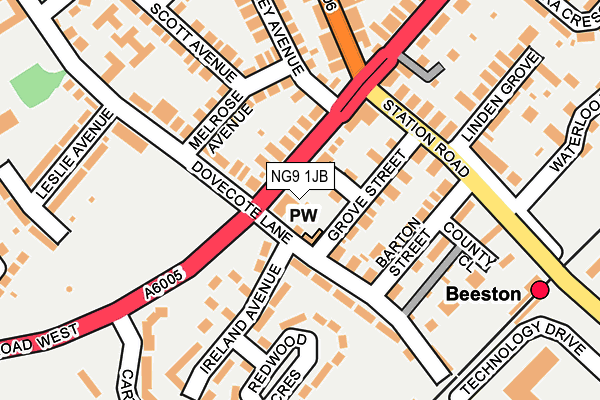
NG9 1JB is located in the Beeston Rylands electoral ward, within the local authority district of Broxtowe and the English Parliamentary constituency of Broxtowe. The Sub Integrated Care Board (ICB) Location is NHS Nottingham and Nottinghamshire ICB - 52R and the police force is Nottinghamshire. This postcode has been in use since January 1980.


GetTheData
Source: OS OpenMap – Local (Ordnance Survey)
Source: OS VectorMap District (Ordnance Survey)
Licence: Open Government Licence (requires attribution)
| Easting | 453133 |
| Northing | 336313 |
| Latitude | 52.921632 |
| Longitude | -1.211163 |
GetTheData
Source: Open Postcode Geo
Licence: Open Government Licence
| Country | England |
| Postcode District | NG9 |
| ➜ NG9 open data dashboard ➜ See where NG9 is on a map ➜ Where is Beeston? | |
GetTheData
Source: Land Registry Price Paid Data
Licence: Open Government Licence
Elevation or altitude of NG9 1JB as distance above sea level:
| Metres | Feet | |
|---|---|---|
| Elevation | 30m | 98ft |
Elevation is measured from the approximate centre of the postcode, to the nearest point on an OS contour line from OS Terrain 50, which has contour spacing of ten vertical metres.
➜ How high above sea level am I? Find the elevation of your current position using your device's GPS.
GetTheData
Source: Open Postcode Elevation
Licence: Open Government Licence
| Ward | Beeston Rylands |
| Constituency | Broxtowe |
GetTheData
Source: ONS Postcode Database
Licence: Open Government Licence
| June 2022 | Violence and sexual offences | On or near Grove Street | 77m |
| June 2022 | Violence and sexual offences | On or near Ireland Close | 113m |
| June 2022 | Criminal damage and arson | On or near Ireland Close | 113m |
| ➜ Get more crime data in our Crime section | |||
GetTheData
Source: data.police.uk
Licence: Open Government Licence
| Dovecote Lane (Queens Road West) | Beeston | 59m |
| Dovecote Lane (Queens Road West) | Beeston | 83m |
| Linden Grove (Station Road) | Beeston | 162m |
| Linden Grove (Station Road) | Beeston | 166m |
| Queens Road (Station Road) | Beeston | 188m |
| Beeston Centre Tram Stop (Styring Street) | Beeston | 481m |
| Chilwell Road Tram Stop (Chilwell Road) | Beeston | 620m |
| Middle Street Tram Stop (Middle Street) | Beeston | 708m |
| High Road - Central College Tram Stop (High Road) | Chilwell | 814m |
| University Boulevard Tram Stop (University Boulevard) | Nottingham University Main Campus | 1,324m |
| Beeston Station | 0.3km |
| Attenborough Station | 2.2km |
| Nottingham Station | 5.2km |
GetTheData
Source: NaPTAN
Licence: Open Government Licence
GetTheData
Source: ONS Postcode Database
Licence: Open Government Licence


➜ Get more ratings from the Food Standards Agency
GetTheData
Source: Food Standards Agency
Licence: FSA terms & conditions
| Last Collection | |||
|---|---|---|---|
| Location | Mon-Fri | Sat | Distance |
| Station Road (Barton Street) | 17:30 | 11:00 | 173m |
| Station Road | 17:30 | 11:00 | 338m |
| West End | 17:00 | 11:00 | 403m |
GetTheData
Source: Dracos
Licence: Creative Commons Attribution-ShareAlike
| Facility | Distance |
|---|---|
| Hetley Pearson Recreation Ground Cartwright Way, Beeston Grass Pitches | 316m |
| Beeston Community Centre West End, Beeston, Nottingham Outdoor Tennis Courts | 331m |
| John Clifford Primary And Nursery School Nether Street, Beeston, Nottingham Grass Pitches | 492m |
GetTheData
Source: Active Places
Licence: Open Government Licence
| School | Phase of Education | Distance |
|---|---|---|
| John Clifford Primary School Nether Street, Beeston, Nottingham, NG9 2AT | Primary | 508m |
| Beeston Rylands Junior School Trent Road, Beeston, Nottingham, NG9 1LJ | Primary | 637m |
| Trent Vale Infant School Trent Road, Beeston Rylands, Nottingham, NG9 1LP | Primary | 748m |
GetTheData
Source: Edubase
Licence: Open Government Licence
| Risk of NG9 1JB flooding from rivers and sea | Low |
| ➜ NG9 1JB flood map | |
GetTheData
Source: Open Flood Risk by Postcode
Licence: Open Government Licence
The below table lists the International Territorial Level (ITL) codes (formerly Nomenclature of Territorial Units for Statistics (NUTS) codes) and Local Administrative Units (LAU) codes for NG9 1JB:
| ITL 1 Code | Name |
|---|---|
| TLF | East Midlands (England) |
| ITL 2 Code | Name |
| TLF1 | Derbyshire and Nottinghamshire |
| ITL 3 Code | Name |
| TLF16 | South Nottinghamshire |
| LAU 1 Code | Name |
| E07000172 | Broxtowe |
GetTheData
Source: ONS Postcode Directory
Licence: Open Government Licence
The below table lists the Census Output Area (OA), Lower Layer Super Output Area (LSOA), and Middle Layer Super Output Area (MSOA) for NG9 1JB:
| Code | Name | |
|---|---|---|
| OA | E00143091 | |
| LSOA | E01028083 | Broxtowe 012D |
| MSOA | E02005861 | Broxtowe 012 |
GetTheData
Source: ONS Postcode Directory
Licence: Open Government Licence
| NG9 1JA | Queens Road | 61m |
| NG9 1JL | Grove Street | 99m |
| NG9 1HW | Melrose Avenue | 106m |
| NG9 1JG | Dovecote Lane | 113m |
| NG9 1JE | Ireland Close | 114m |
| NG9 2AA | Station Road | 137m |
| NG9 1JJ | Barton Street | 144m |
| NG9 1JX | Barton Street | 147m |
| NG9 1JD | Ireland Avenue | 151m |
| NG9 1HU | Dovecote Lane | 157m |
GetTheData
Source: Open Postcode Geo; Land Registry Price Paid Data
Licence: Open Government Licence