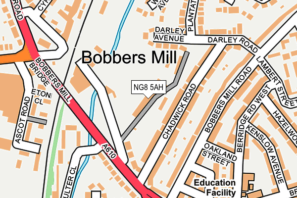
NG8 5AH is located in the Hyson Green & Arboretum electoral ward, within the unitary authority of Nottingham and the English Parliamentary constituency of Nottingham South. The Sub Integrated Care Board (ICB) Location is NHS Nottingham and Nottinghamshire ICB - 52R and the police force is Nottinghamshire. This postcode has been in use since January 1980.


GetTheData
Source: OS OpenMap – Local (Ordnance Survey)
Source: OS VectorMap District (Ordnance Survey)
Licence: Open Government Licence (requires attribution)
| Easting | 455140 |
| Northing | 341340 |
| Latitude | 52.966595 |
| Longitude | -1.180466 |
GetTheData
Source: Open Postcode Geo
Licence: Open Government Licence
| Country | England |
| Postcode District | NG8 |
| ➜ NG8 open data dashboard ➜ See where NG8 is on a map ➜ Where is Nottingham? | |
GetTheData
Source: Land Registry Price Paid Data
Licence: Open Government Licence
Elevation or altitude of NG8 5AH as distance above sea level:
| Metres | Feet | |
|---|---|---|
| Elevation | 40m | 131ft |
Elevation is measured from the approximate centre of the postcode, to the nearest point on an OS contour line from OS Terrain 50, which has contour spacing of ten vertical metres.
➜ How high above sea level am I? Find the elevation of your current position using your device's GPS.
GetTheData
Source: Open Postcode Elevation
Licence: Open Government Licence
| Ward | Hyson Green & Arboretum |
| Constituency | Nottingham South |
GetTheData
Source: ONS Postcode Database
Licence: Open Government Licence
| November 2023 | Violence and sexual offences | On or near Randal Street | 378m |
| October 2023 | Vehicle crime | On or near Randal Street | 378m |
| August 2023 | Anti-social behaviour | On or near Randal Street | 378m |
| ➜ Get more crime data in our Crime section | |||
GetTheData
Source: data.police.uk
Licence: Open Government Licence
| Chadwick Road (Alfreton Road) | Bobbers Mill | 155m |
| Chadwick Road (Alfreton Road) | Bobbers Mill | 186m |
| Alfreton Road (Churchfield Lane) | Radford | 276m |
| Gregory Boulevard (Alfreton Road) | Radford | 276m |
| Ascot Road (Aspley Lane) | Aspley | 285m |
| Radford Road Tram Stop (Radford Road) | Forest Fields | 563m |
| Wilkinson Street Tram Stop (Wilkinson Street) | Basford | 620m |
| Hyson Green Market Tram Stop (Radford Road) | Hyson Green | 653m |
| Shipstone Street Tram Stop (Shipstone Street) | Radford | 724m |
| Beaconsfield Street Tram Stop (Noel Street) | Forest Fields | 765m |
| Nottingham Station | 3.2km |
| Bulwell Station | 3.8km |
GetTheData
Source: NaPTAN
Licence: Open Government Licence
GetTheData
Source: ONS Postcode Database
Licence: Open Government Licence


➜ Get more ratings from the Food Standards Agency
GetTheData
Source: Food Standards Agency
Licence: FSA terms & conditions
| Last Collection | |||
|---|---|---|---|
| Location | Mon-Fri | Sat | Distance |
| Bobbersmill Road | 17:00 | 12:30 | 237m |
| Leacroft Road | 17:30 | 11:00 | 366m |
| Bridlington Street | 17:00 | 12:00 | 403m |
GetTheData
Source: Dracos
Licence: Creative Commons Attribution-ShareAlike
| Facility | Distance |
|---|---|
| Legends Gymnasium Plantation Side, Nottingham Health and Fitness Gym, Studio | 0m |
| Radford Football Club Selhurst Street, Hyson Green, Nottingham Grass Pitches | 517m |
| Nottingham Girls High School Sports Ground Grassington Road, Nottingham Grass Pitches | 563m |
GetTheData
Source: Active Places
Licence: Open Government Licence
| School | Phase of Education | Distance |
|---|---|---|
| Berridge Primary and Nursery School Brushfield Site, Berridge Road West, Hyson Green, Nottingham, NG7 5LE | Primary | 255m |
| Scotholme Primary and Nursery School Fisher Street, Hyson Green, Nottingham, NG7 6FJ | Primary | 696m |
| St Mary's Catholic Primary School Beaconsfield Street, Hyson Green, Nottingham, NG7 6FL | Primary | 734m |
GetTheData
Source: Edubase
Licence: Open Government Licence
| Risk of NG8 5AH flooding from rivers and sea | Medium |
| ➜ NG8 5AH flood map | |
GetTheData
Source: Open Flood Risk by Postcode
Licence: Open Government Licence
The below table lists the International Territorial Level (ITL) codes (formerly Nomenclature of Territorial Units for Statistics (NUTS) codes) and Local Administrative Units (LAU) codes for NG8 5AH:
| ITL 1 Code | Name |
|---|---|
| TLF | East Midlands (England) |
| ITL 2 Code | Name |
| TLF1 | Derbyshire and Nottinghamshire |
| ITL 3 Code | Name |
| TLF14 | Nottingham |
| LAU 1 Code | Name |
| E06000018 | Nottingham |
GetTheData
Source: ONS Postcode Directory
Licence: Open Government Licence
The below table lists the Census Output Area (OA), Lower Layer Super Output Area (LSOA), and Middle Layer Super Output Area (MSOA) for NG8 5AH:
| Code | Name | |
|---|---|---|
| OA | E00070291 | |
| LSOA | E01013930 | Nottingham 019A |
| MSOA | E02002886 | Nottingham 019 |
GetTheData
Source: ONS Postcode Directory
Licence: Open Government Licence
| NG7 5NN | Chadwick Road | 58m |
| NG7 5NP | Chadwick Road | 81m |
| NG7 5NL | Alfreton Road | 108m |
| NG7 5NQ | Darley Avenue | 111m |
| NG7 5JT | Bobbers Mill Road | 117m |
| NG7 5JS | Bobbers Mill Road | 162m |
| NG7 5PJ | Wades Avenue | 172m |
| NG7 5NJ | Alfreton Road | 177m |
| NG7 5JP | Bobbers Mill Road | 177m |
| NG7 5JN | Freiston Street | 182m |
GetTheData
Source: Open Postcode Geo; Land Registry Price Paid Data
Licence: Open Government Licence