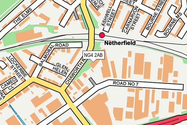
NG4 2AB is located in the Colwick electoral ward, within the local authority district of Gedling and the English Parliamentary constituency of Gedling. The Sub Integrated Care Board (ICB) Location is NHS Nottingham and Nottinghamshire ICB - 52R and the police force is Nottinghamshire. This postcode has been in use since August 1992.


GetTheData
Source: OS OpenMap – Local (Ordnance Survey)
Source: OS VectorMap District (Ordnance Survey)
Licence: Open Government Licence (requires attribution)
| Easting | 461887 |
| Northing | 340765 |
| Latitude | 52.960692 |
| Longitude | -1.080133 |
GetTheData
Source: Open Postcode Geo
Licence: Open Government Licence
| Country | England |
| Postcode District | NG4 |
| ➜ NG4 open data dashboard ➜ See where NG4 is on a map ➜ Where is Carlton? | |
GetTheData
Source: Land Registry Price Paid Data
Licence: Open Government Licence
Elevation or altitude of NG4 2AB as distance above sea level:
| Metres | Feet | |
|---|---|---|
| Elevation | 30m | 98ft |
Elevation is measured from the approximate centre of the postcode, to the nearest point on an OS contour line from OS Terrain 50, which has contour spacing of ten vertical metres.
➜ How high above sea level am I? Find the elevation of your current position using your device's GPS.
GetTheData
Source: Open Postcode Elevation
Licence: Open Government Licence
| Ward | Colwick |
| Constituency | Gedling |
GetTheData
Source: ONS Postcode Database
Licence: Open Government Licence
| January 2024 | Violence and sexual offences | On or near The Elms | 268m |
| January 2024 | Other theft | On or near The Elms | 268m |
| December 2023 | Violence and sexual offences | On or near The Elms | 268m |
| ➜ Get more crime data in our Crime section | |||
GetTheData
Source: data.police.uk
Licence: Open Government Licence
| Chaworth Road | Colwick | 96m |
| Chaworth Road (Vale Road) | Colwick | 161m |
| Private Road No. 8 (Road No 1) | Colwick | 188m |
| Knight Street (Meadow Road) | Netherfield | 243m |
| Knight Street (Meadow Road) | Netherfield | 278m |
| Netherfield Station | 0.1km |
| Carlton Station | 0.5km |
| Radcliffe (Notts) Station | 3.2km |
GetTheData
Source: NaPTAN
Licence: Open Government Licence
GetTheData
Source: ONS Postcode Database
Licence: Open Government Licence


➜ Get more ratings from the Food Standards Agency
GetTheData
Source: Food Standards Agency
Licence: FSA terms & conditions
| Last Collection | |||
|---|---|---|---|
| Location | Mon-Fri | Sat | Distance |
| Colwick | 17:30 | 11:00 | 155m |
| Netherfield Post Office | 17:00 | 11:30 | 344m |
| Private Road 2/3 | 19:00 | 454m | |
GetTheData
Source: Dracos
Licence: Creative Commons Attribution-ShareAlike
| Facility | Distance |
|---|---|
| Oakdale Road Recreation Ground Onchan Avenue, Carlton, Nottingham Outdoor Tennis Courts | 656m |
| St John The Baptist Ce Primary School Vale Road, Colwick, Nottingham Grass Pitches | 669m |
| Conway Road Recreation Ground Conway Crescent, Carlton, Nottingham Outdoor Tennis Courts | 788m |
GetTheData
Source: Active Places
Licence: Open Government Licence
| School | Phase of Education | Distance |
|---|---|---|
| Venture Learning 19A Forester Street, Netherfield, Nottingham, NG4 2LJ | Not applicable | 495m |
| Netherfield Primary School Chandos Street, Netherfield, Nottingham, NG4 2LR | Primary | 832m |
| St John's CofE Primary School Vale Road, Colwick, Nottingham, NG4 2ED | Primary | 926m |
GetTheData
Source: Edubase
Licence: Open Government Licence
| Risk of NG4 2AB flooding from rivers and sea | Low |
| ➜ NG4 2AB flood map | |
GetTheData
Source: Open Flood Risk by Postcode
Licence: Open Government Licence
The below table lists the International Territorial Level (ITL) codes (formerly Nomenclature of Territorial Units for Statistics (NUTS) codes) and Local Administrative Units (LAU) codes for NG4 2AB:
| ITL 1 Code | Name |
|---|---|
| TLF | East Midlands (England) |
| ITL 2 Code | Name |
| TLF1 | Derbyshire and Nottinghamshire |
| ITL 3 Code | Name |
| TLF16 | South Nottinghamshire |
| LAU 1 Code | Name |
| E07000173 | Gedling |
GetTheData
Source: ONS Postcode Directory
Licence: Open Government Licence
The below table lists the Census Output Area (OA), Lower Layer Super Output Area (LSOA), and Middle Layer Super Output Area (MSOA) for NG4 2AB:
| Code | Name | |
|---|---|---|
| OA | E00143611 | |
| LSOA | E01028187 | Gedling 015D |
| MSOA | E02005879 | Gedling 015 |
GetTheData
Source: ONS Postcode Directory
Licence: Open Government Licence
| NG4 2GB | Balmoral Grove | 66m |
| NG4 2FY | Holyoake Villas | 112m |
| NG4 2GE | Glen Helen | 124m |
| NG4 2GD | Balmoral Road | 140m |
| NG4 2FZ | Chaworth Road | 145m |
| NG4 2FU | Beech Avenue | 172m |
| NG4 2FP | Carnarvon Street | 176m |
| NG4 2GF | Balmoral Road | 184m |
| NG4 2FQ | Ashwell Street | 197m |
| NG4 2FN | Knight Street | 211m |
GetTheData
Source: Open Postcode Geo; Land Registry Price Paid Data
Licence: Open Government Licence