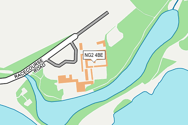
NG2 4BE is located in the Dales electoral ward, within the unitary authority of Nottingham and the English Parliamentary constituency of Nottingham East. The Sub Integrated Care Board (ICB) Location is NHS Nottingham and Nottinghamshire ICB - 52R and the police force is Nottinghamshire. This postcode has been in use since January 1980.


GetTheData
Source: OS OpenMap – Local (Ordnance Survey)
Source: OS VectorMap District (Ordnance Survey)
Licence: Open Government Licence (requires attribution)
| Easting | 460267 |
| Northing | 339086 |
| Latitude | 52.945806 |
| Longitude | -1.104555 |
GetTheData
Source: Open Postcode Geo
Licence: Open Government Licence
| Country | England |
| Postcode District | NG2 |
| ➜ NG2 open data dashboard ➜ See where NG2 is on a map ➜ Where is Nottingham? | |
GetTheData
Source: Land Registry Price Paid Data
Licence: Open Government Licence
Elevation or altitude of NG2 4BE as distance above sea level:
| Metres | Feet | |
|---|---|---|
| Elevation | 30m | 98ft |
Elevation is measured from the approximate centre of the postcode, to the nearest point on an OS contour line from OS Terrain 50, which has contour spacing of ten vertical metres.
➜ How high above sea level am I? Find the elevation of your current position using your device's GPS.
GetTheData
Source: Open Postcode Elevation
Licence: Open Government Licence
| Ward | Dales |
| Constituency | Nottingham East |
GetTheData
Source: ONS Postcode Database
Licence: Open Government Licence
| June 2022 | Anti-social behaviour | On or near Race Track | 27m |
| June 2022 | Drugs | On or near Race Track | 27m |
| June 2022 | Other crime | On or near Race Track | 27m |
| ➜ Get more crime data in our Crime section | |||
GetTheData
Source: data.police.uk
Licence: Open Government Licence
| Greyhound Stadium (Daleside Road) | Colwick Park | 606m |
| Greyhound Stadium (Daleside Road) | Colwick Park | 612m |
| Caravan Park (Adbolton Lane) | Holme Pierrepont | 668m |
| Caravan Park (Adbolton Lane) | Holme Pierrepont | 682m |
| Racecourse Park & Ride | Colwick Park | 715m |
| Netherfield Station | 2.4km |
| Carlton Station | 2.8km |
| Nottingham Station | 2.8km |
GetTheData
Source: NaPTAN
Licence: Open Government Licence
| Percentage of properties with Next Generation Access | 100.0% |
| Percentage of properties with Superfast Broadband | 0.0% |
| Percentage of properties with Ultrafast Broadband | 0.0% |
| Percentage of properties with Full Fibre Broadband | 0.0% |
Superfast Broadband is between 30Mbps and 300Mbps
Ultrafast Broadband is > 300Mbps
| Percentage of properties unable to receive 2Mbps | 0.0% |
| Percentage of properties unable to receive 5Mbps | 0.0% |
| Percentage of properties unable to receive 10Mbps | 0.0% |
| Percentage of properties unable to receive 30Mbps | 100.0% |
GetTheData
Source: Ofcom
Licence: Ofcom Terms of Use (requires attribution)
GetTheData
Source: ONS Postcode Database
Licence: Open Government Licence


➜ Get more ratings from the Food Standards Agency
GetTheData
Source: Food Standards Agency
Licence: FSA terms & conditions
| Last Collection | |||
|---|---|---|---|
| Location | Mon-Fri | Sat | Distance |
| Greenacre Caravan Site | 17:00 | 12:00 | 876m |
| Julian Road | 17:00 | 12:00 | 1,116m |
| Trent Lane | 17:00 | 11:30 | 1,240m |
GetTheData
Source: Dracos
Licence: Creative Commons Attribution-ShareAlike
| Facility | Distance |
|---|---|
| Colwick Racecourse (Closed) Racecourse Road, Nottingham Grass Pitches | 365m |
| Old Nottinghamians Sports Ground Adbolton Lane, Holme Pierrepont Grass Pitches | 871m |
| National Watersports Centre Holme Pierrepont Adbolton Lane, Holme Pierrepont Sports Hall, Health and Fitness Gym, Studio | 988m |
GetTheData
Source: Active Places
Licence: Open Government Licence
| School | Phase of Education | Distance |
|---|---|---|
| Nottingham Academy Greenwood Road, Bakersfield, Nottingham, NG3 7EB | All-through | 1.2km |
| Windmill L.E.A.D. Academy Sneinton Boulevard, Nottingham, NG2 4FZ | Primary | 1.4km |
| St John's CofE Primary School Vale Road, Colwick, Nottingham, NG4 2ED | Primary | 1.4km |
GetTheData
Source: Edubase
Licence: Open Government Licence
| Risk of NG2 4BE flooding from rivers and sea | Low |
| ➜ NG2 4BE flood map | |
GetTheData
Source: Open Flood Risk by Postcode
Licence: Open Government Licence
The below table lists the International Territorial Level (ITL) codes (formerly Nomenclature of Territorial Units for Statistics (NUTS) codes) and Local Administrative Units (LAU) codes for NG2 4BE:
| ITL 1 Code | Name |
|---|---|
| TLF | East Midlands (England) |
| ITL 2 Code | Name |
| TLF1 | Derbyshire and Nottinghamshire |
| ITL 3 Code | Name |
| TLF14 | Nottingham |
| LAU 1 Code | Name |
| E06000018 | Nottingham |
GetTheData
Source: ONS Postcode Directory
Licence: Open Government Licence
The below table lists the Census Output Area (OA), Lower Layer Super Output Area (LSOA), and Middle Layer Super Output Area (MSOA) for NG2 4BE:
| Code | Name | |
|---|---|---|
| OA | E00173466 | |
| LSOA | E01013920 | Nottingham 029C |
| MSOA | E02002896 | Nottingham 029 |
GetTheData
Source: ONS Postcode Directory
Licence: Open Government Licence
| NG2 5AS | Adbolton Lane | 712m |
| NG2 4BG | Colwick Road | 728m |
| NG2 5AH | Holme Grove | 904m |
| NG2 4BD | Colwick Crossing | 919m |
| NG2 5AG | Holme Road | 926m |
| NG2 5AF | Holme Road | 947m |
| NG2 5AR | Adbolton Grove | 948m |
| NG2 4EE | Windmill View | 968m |
| NG2 5AJ | Julian Road | 977m |
| NG2 4EL | Little Tennis Street | 988m |
GetTheData
Source: Open Postcode Geo; Land Registry Price Paid Data
Licence: Open Government Licence