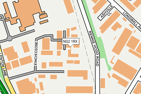
NG2 1RX lies on Rennie Hogg Road in Nottingham. NG2 1RX is located in the Meadows electoral ward, within the unitary authority of Nottingham and the English Parliamentary constituency of Nottingham South. The Sub Integrated Care Board (ICB) Location is NHS Nottingham and Nottinghamshire ICB - 52R and the police force is Nottinghamshire. This postcode has been in use since July 1995.


GetTheData
Source: OS OpenMap – Local (Ordnance Survey)
Source: OS VectorMap District (Ordnance Survey)
Licence: Open Government Licence (requires attribution)
| Easting | 455950 |
| Northing | 338077 |
| Latitude | 52.937203 |
| Longitude | -1.168967 |
GetTheData
Source: Open Postcode Geo
Licence: Open Government Licence
| Street | Rennie Hogg Road |
| Town/City | Nottingham |
| Country | England |
| Postcode District | NG2 |
➜ See where NG2 is on a map ➜ Where is Nottingham? | |
GetTheData
Source: Land Registry Price Paid Data
Licence: Open Government Licence
Elevation or altitude of NG2 1RX as distance above sea level:
| Metres | Feet | |
|---|---|---|
| Elevation | 30m | 98ft |
Elevation is measured from the approximate centre of the postcode, to the nearest point on an OS contour line from OS Terrain 50, which has contour spacing of ten vertical metres.
➜ How high above sea level am I? Find the elevation of your current position using your device's GPS.
GetTheData
Source: Open Postcode Elevation
Licence: Open Government Licence
| Ward | Meadows |
| Constituency | Nottingham South |
GetTheData
Source: ONS Postcode Database
Licence: Open Government Licence
| Kings Meadow Campus (Lenton Lane) | Lenton Lane Industrial Estate | 295m |
| Crossgate Drive End (Crossgate Drive) | Queens Drive Industrial Estate | 298m |
| Kings Meadow Campus (Lenton Lane) | Lenton Lane Industrial Estate | 308m |
| King's Meadow Campus (Unmarked) | Lenton Lane Industrial Estate | 310m |
| Finch Close (Lenton Lane) | Lenton Lane Industrial Estate | 318m |
| Ng2 Tram Stop (Enterprise Way) | Lenton Lane Industrial Estate | 576m |
| Wilford Village Tram Stop (Main Road) | Wilford | 908m |
| Gregory Street Tram Stop (Lenton Lane) | Lenton | 921m |
| Meadows Embankment Tram Stop (Queens Walk) | Meadows | 1,049m |
| Meadows Way West Tram Stop (Meadows Way) | Meadows | 1,075m |
| Nottingham Station | 1.9km |
| Beeston Station | 3.2km |
| Attenborough Station | 5.4km |
GetTheData
Source: NaPTAN
Licence: Open Government Licence
Estimated total energy consumption in NG2 1RX by fuel type, 2015.
| Consumption (kWh) | 247,734 |
|---|---|
| Meter count | 6 |
| Mean (kWh/meter) | 41,289 |
| Median (kWh/meter) | 40,049 |
GetTheData
Source: Postcode level gas estimates: 2015 (experimental)
Source: Postcode level electricity estimates: 2015 (experimental)
Licence: Open Government Licence
GetTheData
Source: ONS Postcode Database
Licence: Open Government Licence


➜ Get more ratings from the Food Standards Agency
GetTheData
Source: Food Standards Agency
Licence: FSA terms & conditions
| Last Collection | |||
|---|---|---|---|
| Location | Mon-Fri | Sat | Distance |
| Lenton Lane | 185m | ||
| Lenton Lane | 17:30 | 11:00 | 319m |
| Crossgate Drive | 421m | ||
GetTheData
Source: Dracos
Licence: Creative Commons Attribution-ShareAlike
| Risk of NG2 1RX flooding from rivers and sea | Low |
| ➜ NG2 1RX flood map | |
GetTheData
Source: Open Flood Risk by Postcode
Licence: Open Government Licence
The below table lists the International Territorial Level (ITL) codes (formerly Nomenclature of Territorial Units for Statistics (NUTS) codes) and Local Administrative Units (LAU) codes for NG2 1RX:
| ITL 1 Code | Name |
|---|---|
| TLF | East Midlands (England) |
| ITL 2 Code | Name |
| TLF1 | Derbyshire and Nottinghamshire |
| ITL 3 Code | Name |
| TLF14 | Nottingham |
| LAU 1 Code | Name |
| E06000018 | Nottingham |
GetTheData
Source: ONS Postcode Directory
Licence: Open Government Licence
The below table lists the Census Output Area (OA), Lower Layer Super Output Area (LSOA), and Middle Layer Super Output Area (MSOA) for NG2 1RX:
| Code | Name | |
|---|---|---|
| OA | E00069977 | |
| LSOA | E01013870 | Nottingham 040A |
| MSOA | E02006905 | Nottingham 040 |
GetTheData
Source: ONS Postcode Directory
Licence: Open Government Licence
| NG2 1AE | The Triangle | 465m |
| NG7 2PX | Lenton Lane | 578m |
| NG7 2SB | Gibbons Street | 670m |
| NG2 1PA | Anmer Close | 704m |
| NG2 1PL | Royston Close | 708m |
| NG7 2UJ | Redfield Road | 716m |
| NG7 2LF | Dunkirk Road | 737m |
| NG7 1TH | Avocet Wharf | 752m |
| NG7 1TL | Plover Wharf | 755m |
| NG2 1DP | Riverside Way | 756m |
GetTheData
Source: Open Postcode Geo; Land Registry Price Paid Data
Licence: Open Government Licence