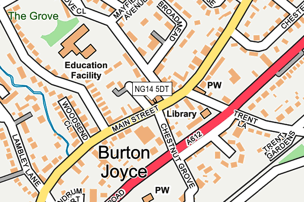
NG14 5DT is located in the Trent Valley electoral ward, within the local authority district of Gedling and the English Parliamentary constituency of Gedling. The Sub Integrated Care Board (ICB) Location is NHS Nottingham and Nottinghamshire ICB - 52R and the police force is Nottinghamshire. This postcode has been in use since December 1998.


GetTheData
Source: OS OpenMap – Local (Ordnance Survey)
Source: OS VectorMap District (Ordnance Survey)
Licence: Open Government Licence (requires attribution)
| Easting | 464791 |
| Northing | 343889 |
| Latitude | 52.988428 |
| Longitude | -1.036283 |
GetTheData
Source: Open Postcode Geo
Licence: Open Government Licence
| Country | England |
| Postcode District | NG14 |
| ➜ NG14 open data dashboard ➜ See where NG14 is on a map ➜ Where is Burton Joyce? | |
GetTheData
Source: Land Registry Price Paid Data
Licence: Open Government Licence
Elevation or altitude of NG14 5DT as distance above sea level:
| Metres | Feet | |
|---|---|---|
| Elevation | 20m | 66ft |
Elevation is measured from the approximate centre of the postcode, to the nearest point on an OS contour line from OS Terrain 50, which has contour spacing of ten vertical metres.
➜ How high above sea level am I? Find the elevation of your current position using your device's GPS.
GetTheData
Source: Open Postcode Elevation
Licence: Open Government Licence
| Ward | Trent Valley |
| Constituency | Gedling |
GetTheData
Source: ONS Postcode Database
Licence: Open Government Licence
| June 2022 | Shoplifting | On or near Supermarket | 69m |
| June 2022 | Shoplifting | On or near Supermarket | 69m |
| June 2022 | Shoplifting | On or near Supermarket | 69m |
| ➜ Get more crime data in our Crime section | |||
GetTheData
Source: data.police.uk
Licence: Open Government Licence
| Wheatsheaf Court (Main Street) | Burton Joyce | 9m |
| Wheatsheaf Court (Main Street) | Burton Joyce | 27m |
| Chesterfield Drive (Main Street) | Burton Joyce | 273m |
| Lambley Lane (Main Street) | Burton Joyce | 310m |
| Lambley Lane (Main Street) | Burton Joyce | 342m |
| Burton Joyce Station | 0.6km |
| Lowdham Station | 3.2km |
| Carlton Station | 3.9km |
GetTheData
Source: NaPTAN
Licence: Open Government Licence
GetTheData
Source: ONS Postcode Database
Licence: Open Government Licence


➜ Get more ratings from the Food Standards Agency
GetTheData
Source: Food Standards Agency
Licence: FSA terms & conditions
| Last Collection | |||
|---|---|---|---|
| Location | Mon-Fri | Sat | Distance |
| Burton Joyce Post Office | 17:00 | 12:00 | 10m |
| Wellington Road | 17:00 | 12:00 | 548m |
| Crow Park Drive | 17:00 | 12:00 | 872m |
GetTheData
Source: Dracos
Licence: Creative Commons Attribution-ShareAlike
| Facility | Distance |
|---|---|
| Burton Joyce Primary School Padleys Lane, Burton Joyce, Nottingham Grass Pitches | 167m |
| Poplars Sports Ground Station Road, Burton Joyce Grass Pitches, Artificial Grass Pitch | 864m |
| Riverside Ground Riverside, Stoke Bardolph, Burton Joyce, Nottingham Grass Pitches | 1.8km |
GetTheData
Source: Active Places
Licence: Open Government Licence
| School | Phase of Education | Distance |
|---|---|---|
| Burton Joyce Primary School Padleys Lane, Burton Joyce, Nottingham, NG14 5EB | Primary | 167m |
| Lambley Primary School Catfoot Lane, Lambley, Nottingham, NG4 4QF | Primary | 2.5km |
| Carlton le Willows Academy Wood Lane, Nottingham, Gedling, NG4 4AA | Secondary | 2.5km |
GetTheData
Source: Edubase
Licence: Open Government Licence
| Risk of NG14 5DT flooding from rivers and sea | Low |
| ➜ NG14 5DT flood map | |
GetTheData
Source: Open Flood Risk by Postcode
Licence: Open Government Licence
The below table lists the International Territorial Level (ITL) codes (formerly Nomenclature of Territorial Units for Statistics (NUTS) codes) and Local Administrative Units (LAU) codes for NG14 5DT:
| ITL 1 Code | Name |
|---|---|
| TLF | East Midlands (England) |
| ITL 2 Code | Name |
| TLF1 | Derbyshire and Nottinghamshire |
| ITL 3 Code | Name |
| TLF16 | South Nottinghamshire |
| LAU 1 Code | Name |
| E07000173 | Gedling |
GetTheData
Source: ONS Postcode Directory
Licence: Open Government Licence
The below table lists the Census Output Area (OA), Lower Layer Super Output Area (LSOA), and Middle Layer Super Output Area (MSOA) for NG14 5DT:
| Code | Name | |
|---|---|---|
| OA | E00143418 | |
| LSOA | E01028148 | Gedling 008A |
| MSOA | E02005872 | Gedling 008 |
GetTheData
Source: ONS Postcode Directory
Licence: Open Government Licence
| NG14 5DP | Chestnut Grove | 67m |
| NG14 5DZ | Main Street | 69m |
| NG14 5EA | Wheatsheaf Court | 75m |
| NG14 5FD | Willow Wong | 100m |
| NG14 5EB | Padleys Lane | 107m |
| NG14 5DQ | Church Road | 114m |
| NG14 5EX | Meadow Lane | 116m |
| NG14 5FZ | Willow Wong | 121m |
| NG14 5DX | Main Street | 124m |
| NG14 5DR | Tim Lane | 133m |
GetTheData
Source: Open Postcode Geo; Land Registry Price Paid Data
Licence: Open Government Licence