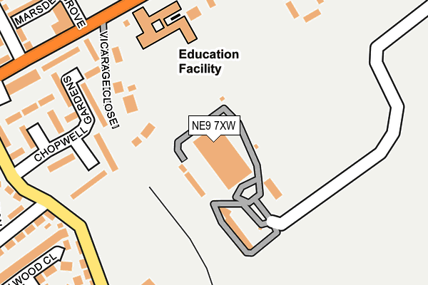
NE9 7XW is located in the Washington West electoral ward, within the metropolitan district of Sunderland and the English Parliamentary constituency of Washington and Sunderland West. The Sub Integrated Care Board (ICB) Location is NHS North East and North Cumbria ICB - 00P and the police force is Northumbria. This postcode has been in use since January 1980.


GetTheData
Source: OS OpenMap – Local (Ordnance Survey)
Source: OS VectorMap District (Ordnance Survey)
Licence: Open Government Licence (requires attribution)
| Easting | 427838 |
| Northing | 558986 |
| Latitude | 54.924792 |
| Longitude | -1.567170 |
GetTheData
Source: Open Postcode Geo
Licence: Open Government Licence
| Country | England |
| Postcode District | NE9 |
| ➜ NE9 open data dashboard ➜ See where NE9 is on a map ➜ Where is Gateshead? | |
GetTheData
Source: Land Registry Price Paid Data
Licence: Open Government Licence
Elevation or altitude of NE9 7XW as distance above sea level:
| Metres | Feet | |
|---|---|---|
| Elevation | 150m | 492ft |
Elevation is measured from the approximate centre of the postcode, to the nearest point on an OS contour line from OS Terrain 50, which has contour spacing of ten vertical metres.
➜ How high above sea level am I? Find the elevation of your current position using your device's GPS.
GetTheData
Source: Open Postcode Elevation
Licence: Open Government Licence
| Ward | Washington West |
| Constituency | Washington And Sunderland West |
GetTheData
Source: ONS Postcode Database
Licence: Open Government Licence
| January 2024 | Criminal damage and arson | On or near Chopwell Gardens | 250m |
| January 2024 | Other theft | On or near Chopwell Gardens | 250m |
| January 2024 | Anti-social behaviour | On or near Chopwell Gardens | 250m |
| ➜ Get more crime data in our Crime section | |||
GetTheData
Source: data.police.uk
Licence: Open Government Licence
| Springwell Road-social Club (Sprinwell Road) | Wrekenton | 256m |
| Springwell Road-health Centre (Springwell Road) | Wrekenton | 262m |
| Springwell Rd-felldyke School (Springwell Road) | Springwell Estate | 268m |
| Lanchester Ave-springwell Rd (Lanchester Avenue) | Springwell Estate | 290m |
| Lanchester Ave-springwell Rd (Lanchester Avenue) | Springwell Estate | 298m |
| Heworth Station | 3.1km |
| Dunston Station | 5.6km |
| Newcastle Station | 5.8km |
GetTheData
Source: NaPTAN
Licence: Open Government Licence
GetTheData
Source: ONS Postcode Database
Licence: Open Government Licence


➜ Get more ratings from the Food Standards Agency
GetTheData
Source: Food Standards Agency
Licence: FSA terms & conditions
| Last Collection | |||
|---|---|---|---|
| Location | Mon-Fri | Sat | Distance |
| Springwell Road | 16:00 | 10:30 | 322m |
| Cypress Road | 17:30 | 10:30 | 374m |
| Wrekenton Post Office | 17:45 | 12:00 | 496m |
GetTheData
Source: Dracos
Licence: Creative Commons Attribution-ShareAlike
| Facility | Distance |
|---|---|
| Wrekenton Nou Camp Yfc Springwell Road, Wrekenton, Gateshead Grass Pitches | 129m |
| Fell Dyke Primary School Springwell Road, Wrekenton, Gateshead Grass Pitches | 185m |
| St Edmund Campion Rc School Sports Hall (Closed) Rugby Gardens, Gateshead Sports Hall, Swimming Pool, Grass Pitches | 617m |
GetTheData
Source: Active Places
Licence: Open Government Licence
| School | Phase of Education | Distance |
|---|---|---|
| Fell Dyke Community Primary School Springwell Road, Gateshead, NE9 7AA | Primary | 285m |
| St Oswald's Catholic Primary, Wrekenton Easington Avenue, Wrekenton, Gateshead, NE9 7LH | Primary | 485m |
| Hill Top School Wealcroft, Felling, Gateshead, NE10 8LT | Not applicable | 968m |
GetTheData
Source: Edubase
Licence: Open Government Licence
The below table lists the International Territorial Level (ITL) codes (formerly Nomenclature of Territorial Units for Statistics (NUTS) codes) and Local Administrative Units (LAU) codes for NE9 7XW:
| ITL 1 Code | Name |
|---|---|
| TLC | North East (England) |
| ITL 2 Code | Name |
| TLC2 | Northumberland, and Tyne and Wear |
| ITL 3 Code | Name |
| TLC23 | Sunderland |
| LAU 1 Code | Name |
| E08000024 | Sunderland |
GetTheData
Source: ONS Postcode Directory
Licence: Open Government Licence
The below table lists the Census Output Area (OA), Lower Layer Super Output Area (LSOA), and Middle Layer Super Output Area (MSOA) for NE9 7XW:
| Code | Name | |
|---|---|---|
| OA | E00045075 | |
| LSOA | E01008877 | Sunderland 007D |
| MSOA | E02001797 | Sunderland 007 |
GetTheData
Source: ONS Postcode Directory
Licence: Open Government Licence
| NE9 7QE | Chopwell Gardens | 198m |
| NE9 7AA | Springwell Road | 213m |
| NE9 7AU | Seaburn Gardens | 233m |
| NE9 7QD | Chopwell Gardens | 247m |
| NE9 7XA | Galloping Green Road | 262m |
| NE9 7XG | Galloping Green Farm Close | 303m |
| NE9 7BH | Trimdon Grove | 306m |
| NE9 7LT | Westwood Gardens | 308m |
| NE9 7AT | Galloping Green Road | 312m |
| NE9 7LX | Marsden Grove | 326m |
GetTheData
Source: Open Postcode Geo; Land Registry Price Paid Data
Licence: Open Government Licence