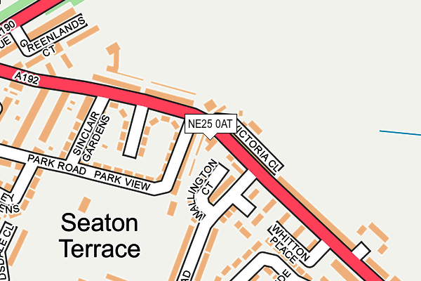
NE25 0AT is located in the Holywell electoral ward, within the unitary authority of Northumberland and the English Parliamentary constituency of Blyth Valley. The Sub Integrated Care Board (ICB) Location is NHS North East and North Cumbria ICB - 00L and the police force is Northumbria. This postcode has been in use since January 1980.


GetTheData
Source: OS OpenMap – Local (Ordnance Survey)
Source: OS VectorMap District (Ordnance Survey)
Licence: Open Government Licence (requires attribution)
| Easting | 430778 |
| Northing | 575383 |
| Latitude | 55.071961 |
| Longitude | -1.519543 |
GetTheData
Source: Open Postcode Geo
Licence: Open Government Licence
| Country | England |
| Postcode District | NE25 |
| ➜ NE25 open data dashboard ➜ See where NE25 is on a map ➜ Where is Seaton Delaval? | |
GetTheData
Source: Land Registry Price Paid Data
Licence: Open Government Licence
Elevation or altitude of NE25 0AT as distance above sea level:
| Metres | Feet | |
|---|---|---|
| Elevation | 30m | 98ft |
Elevation is measured from the approximate centre of the postcode, to the nearest point on an OS contour line from OS Terrain 50, which has contour spacing of ten vertical metres.
➜ How high above sea level am I? Find the elevation of your current position using your device's GPS.
GetTheData
Source: Open Postcode Elevation
Licence: Open Government Licence
| Ward | Holywell |
| Constituency | Blyth Valley |
GetTheData
Source: ONS Postcode Database
Licence: Open Government Licence
| January 2024 | Shoplifting | On or near Dartford Close | 269m |
| January 2024 | Burglary | On or near Dartford Close | 269m |
| January 2024 | Shoplifting | On or near Dartford Close | 269m |
| ➜ Get more crime data in our Crime section | |||
GetTheData
Source: data.police.uk
Licence: Open Government Licence
| Seaton Terrace (A192) | Seaton Delaval | 35m |
| Seaton Terrace (A192) | Seaton Delaval | 140m |
| Avenue Head Memorial (A192) | Seaton Delaval | 305m |
| Avenue Head (A192) | Seaton Delaval | 313m |
| Westbourne Garage (A192) | Seaton Delaval | 324m |
GetTheData
Source: NaPTAN
Licence: Open Government Licence
GetTheData
Source: ONS Postcode Database
Licence: Open Government Licence


➜ Get more ratings from the Food Standards Agency
GetTheData
Source: Food Standards Agency
Licence: FSA terms & conditions
| Last Collection | |||
|---|---|---|---|
| Location | Mon-Fri | Sat | Distance |
| Seaton Terrace | 16:30 | 11:30 | 27m |
| Elsdon Avenue | 16:30 | 11:30 | 322m |
| Seaton Delaval Post Office | 17:45 | 11:30 | 362m |
GetTheData
Source: Dracos
Licence: Creative Commons Attribution-ShareAlike
| Facility | Distance |
|---|---|
| Astley Community High School Elsdon Avenue, Seaton Delaval, Whitley Bay Sports Hall, Swimming Pool, Health and Fitness Gym, Grass Pitches | 456m |
| Bates Welfare Medburn Road, Seaton Delaval, Whitley Bay Grass Pitches | 620m |
| Whytrig Community Middle School (Closed) Western Avenue, Seaton Delaval, Whitley Bay Sports Hall, Grass Pitches | 718m |
GetTheData
Source: Active Places
Licence: Open Government Licence
| School | Phase of Education | Distance |
|---|---|---|
| Whytrig Community Middle School Elsdon Avenue, Seaton Delaval, Whitley Bay, NE25 0BP | Middle deemed secondary | 399m |
| Astley Community High School Elsdon Avenue, Seaton Delaval, NE25 0BP | Secondary | 456m |
| Seaton Delaval First School Western Avenue, Seaton Delaval, Whitley Bay, NE25 0EP | Primary | 868m |
GetTheData
Source: Edubase
Licence: Open Government Licence
The below table lists the International Territorial Level (ITL) codes (formerly Nomenclature of Territorial Units for Statistics (NUTS) codes) and Local Administrative Units (LAU) codes for NE25 0AT:
| ITL 1 Code | Name |
|---|---|
| TLC | North East (England) |
| ITL 2 Code | Name |
| TLC2 | Northumberland, and Tyne and Wear |
| ITL 3 Code | Name |
| TLC21 | Northumberland |
| LAU 1 Code | Name |
| E06000057 | Northumberland |
GetTheData
Source: ONS Postcode Directory
Licence: Open Government Licence
The below table lists the Census Output Area (OA), Lower Layer Super Output Area (LSOA), and Middle Layer Super Output Area (MSOA) for NE25 0AT:
| Code | Name | |
|---|---|---|
| OA | E00139626 | |
| LSOA | E01027432 | Northumberland 032A |
| MSOA | E02005719 | Northumberland 032 |
GetTheData
Source: ONS Postcode Directory
Licence: Open Government Licence
| NE25 0AS | Cooperative Buildings | 34m |
| NE25 0DA | Wallington Court | 42m |
| NE25 0AW | Avenue Terrace | 44m |
| NE25 0AX | Baxters Buildings | 75m |
| NE25 0AN | Park View | 92m |
| NE25 0AL | Park View | 111m |
| NE25 0AP | Baxter Place | 127m |
| NE25 0BF | Nursery Gardens | 131m |
| NE25 0BJ | Whitton Place | 153m |
| NE25 0AY | Hartburn Terrace | 182m |
GetTheData
Source: Open Postcode Geo; Land Registry Price Paid Data
Licence: Open Government Licence