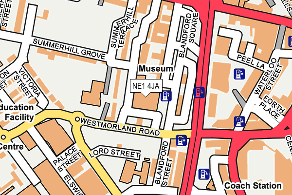
NE1 4JA is located in the Monument electoral ward, within the metropolitan district of Newcastle upon Tyne and the English Parliamentary constituency of Newcastle upon Tyne Central. The Sub Integrated Care Board (ICB) Location is NHS North East and North Cumbria ICB - 13T and the police force is Northumbria. This postcode has been in use since January 1980.


GetTheData
Source: OS OpenMap – Local (Ordnance Survey)
Source: OS VectorMap District (Ordnance Survey)
Licence: Open Government Licence (requires attribution)
| Easting | 424121 |
| Northing | 563900 |
| Latitude | 54.969142 |
| Longitude | -1.624755 |
GetTheData
Source: Open Postcode Geo
Licence: Open Government Licence
| Country | England |
| Postcode District | NE1 |
| ➜ NE1 open data dashboard ➜ See where NE1 is on a map ➜ Where is Newcastle upon Tyne? | |
GetTheData
Source: Land Registry Price Paid Data
Licence: Open Government Licence
Elevation or altitude of NE1 4JA as distance above sea level:
| Metres | Feet | |
|---|---|---|
| Elevation | 50m | 164ft |
Elevation is measured from the approximate centre of the postcode, to the nearest point on an OS contour line from OS Terrain 50, which has contour spacing of ten vertical metres.
➜ How high above sea level am I? Find the elevation of your current position using your device's GPS.
GetTheData
Source: Open Postcode Elevation
Licence: Open Government Licence
| Ward | Monument |
| Constituency | Newcastle Upon Tyne Central |
GetTheData
Source: ONS Postcode Database
Licence: Open Government Licence
| January 2024 | Anti-social behaviour | On or near Sunderland Street | 211m |
| January 2024 | Anti-social behaviour | On or near Sunderland Street | 211m |
| January 2024 | Anti-social behaviour | On or near Sunderland Street | 211m |
| ➜ Get more crime data in our Crime section | |||
GetTheData
Source: data.police.uk
Licence: Open Government Licence
| Westmorland Rd-discovery Msm (Westmorland Road) | Newcastle Upon Tyne | 63m |
| Westmorland Rd-discovery Msm (Westmorland Road) | Newcastle Upon Tyne | 78m |
| Westgate Road-westgate Hill (Westgate Road) | Newcastle Upon Tyne | 206m |
| Westgate Rd-rutherford St (Westgate Road) | Newcastle Upon Tyne | 250m |
| Westmorland Road | Elswick | 274m |
| Central Station (Tyne And Wear Metro Station) (Neville Street) | Newcastle Upon Tyne | 552m |
| St James (Tyne And Wear Metro Station) (Strawberry Place) | Newcastle Upon Tyne | 600m |
| Monument (Tyne And Wear Metro Station) (Blackett Street) | Newcastle Upon Tyne | 879m |
| Haymarket (Tyne And Wear Metro Station) (Percy Street) | Newcastle Upon Tyne | 1,163m |
| Manors (Tyne And Wear Metro Station) (Argyll Street) | Manors | 1,387m |
| Newcastle Station | 0.5km |
| Manors Station | 1.3km |
| Dunston Station | 2.4km |
GetTheData
Source: NaPTAN
Licence: Open Government Licence
GetTheData
Source: ONS Postcode Database
Licence: Open Government Licence

➜ Get more ratings from the Food Standards Agency
GetTheData
Source: Food Standards Agency
Licence: FSA terms & conditions
| Last Collection | |||
|---|---|---|---|
| Location | Mon-Fri | Sat | Distance |
| Rye Hill | 18:15 | 12:00 | 196m |
| Waterloo Street | 18:30 | 11:30 | 206m |
| 245 Westgate Road | 17:45 | 11:45 | 274m |
GetTheData
Source: Dracos
Licence: Creative Commons Attribution-ShareAlike
| Facility | Distance |
|---|---|
| Puregym (Newcastle St James) Saint James Boulevard, Newcastle Upon Tyne Health and Fitness Gym, Studio | 209m |
| Newcastle College Sports Centre Scotswood Road, Newcastle Upon Tyne Health and Fitness Gym, Sports Hall | 341m |
| The Zone @ The Lifestyle Academy Scotswood Road, Newcastle Upon Tyne Health and Fitness Gym, Studio | 350m |
GetTheData
Source: Active Places
Licence: Open Government Licence
| School | Phase of Education | Distance |
|---|---|---|
| Our Lady and St Anne's Catholic Primary School Summerhill Terrace, Newcastle-upon-Tyne, NE4 6EB | Primary | 124m |
| Callerton Academy Blandford Street, Newcastle-upon-Tyne, NE1 3BT | Secondary | 154m |
| St Paul's CofE Primary School Victoria Street, Newcastle-upon-Tyne, NE4 7JU | Primary | 336m |
GetTheData
Source: Edubase
Licence: Open Government Licence
The below table lists the International Territorial Level (ITL) codes (formerly Nomenclature of Territorial Units for Statistics (NUTS) codes) and Local Administrative Units (LAU) codes for NE1 4JA:
| ITL 1 Code | Name |
|---|---|
| TLC | North East (England) |
| ITL 2 Code | Name |
| TLC2 | Northumberland, and Tyne and Wear |
| ITL 3 Code | Name |
| TLC22 | Tyneside |
| LAU 1 Code | Name |
| E08000021 | Newcastle upon Tyne |
GetTheData
Source: ONS Postcode Directory
Licence: Open Government Licence
The below table lists the Census Output Area (OA), Lower Layer Super Output Area (LSOA), and Middle Layer Super Output Area (MSOA) for NE1 4JA:
| Code | Name | |
|---|---|---|
| OA | E00042825 | |
| LSOA | E01033554 | Newcastle upon Tyne 024I |
| MSOA | E02001731 | Newcastle upon Tyne 024 |
GetTheData
Source: ONS Postcode Directory
Licence: Open Government Licence
| NE4 6EB | Summerhill Terrace | 73m |
| NE4 6EF | Westmorland Road | 79m |
| NE1 4HZ | Blandford Square | 120m |
| NE4 6AS | Westgate Hill Terrace | 161m |
| NE1 4EQ | Westmorland Road | 166m |
| NE4 7JS | Westmorland Road | 176m |
| NE1 4DP | Waterloo Square | 177m |
| NE4 6EE | Summerhill Grove | 196m |
| NE4 6EA | Swinburne Place | 198m |
| NE4 6AA | Westgate Road | 198m |
GetTheData
Source: Open Postcode Geo; Land Registry Price Paid Data
Licence: Open Government Licence