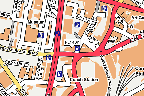
NE1 4DP lies on Waterloo Square in Newcastle Upon Tyne. NE1 4DP is located in the Monument electoral ward, within the metropolitan district of Newcastle upon Tyne and the English Parliamentary constituency of Newcastle upon Tyne Central. The Sub Integrated Care Board (ICB) Location is NHS North East and North Cumbria ICB - 13T and the police force is Northumbria. This postcode has been in use since April 2006.


GetTheData
Source: OS OpenMap – Local (Ordnance Survey)
Source: OS VectorMap District (Ordnance Survey)
Licence: Open Government Licence (requires attribution)
| Easting | 424291 |
| Northing | 563851 |
| Latitude | 54.968694 |
| Longitude | -1.622104 |
GetTheData
Source: Open Postcode Geo
Licence: Open Government Licence
| Street | Waterloo Square |
| Town/City | Newcastle Upon Tyne |
| Country | England |
| Postcode District | NE1 |
➜ See where NE1 is on a map ➜ Where is Newcastle upon Tyne? | |
GetTheData
Source: Land Registry Price Paid Data
Licence: Open Government Licence
Elevation or altitude of NE1 4DP as distance above sea level:
| Metres | Feet | |
|---|---|---|
| Elevation | 40m | 131ft |
Elevation is measured from the approximate centre of the postcode, to the nearest point on an OS contour line from OS Terrain 50, which has contour spacing of ten vertical metres.
➜ How high above sea level am I? Find the elevation of your current position using your device's GPS.
GetTheData
Source: Open Postcode Elevation
Licence: Open Government Licence
| Ward | Monument |
| Constituency | Newcastle Upon Tyne Central |
GetTheData
Source: ONS Postcode Database
Licence: Open Government Licence
| Central Stn Clayton St (A186) | Newcastle Upon Tyne | 129m |
| Central Stn Clayton St (A186) | Newcastle Upon Tyne | 161m |
| Central Stn Neville St (A186) | Newcastle Upon Tyne | 185m |
| Westmorland Rd-discovery Msm (Westmorland Road) | Newcastle Upon Tyne | 192m |
| Westmorland Rd-discovery Msm (Westmorland Road) | Newcastle Upon Tyne | 201m |
| Central Station (Tyne And Wear Metro Station) (Neville Street) | Newcastle Upon Tyne | 385m |
| St James (Tyne And Wear Metro Station) (Strawberry Place) | Newcastle Upon Tyne | 603m |
| Monument (Tyne And Wear Metro Station) (Blackett Street) | Newcastle Upon Tyne | 781m |
| Haymarket (Tyne And Wear Metro Station) (Percy Street) | Newcastle Upon Tyne | 1,113m |
| Manors (Tyne And Wear Metro Station) (Argyll Street) | Manors | 1,255m |
| Newcastle Station | 0.3km |
| Manors Station | 1.2km |
| Dunston Station | 2.4km |
GetTheData
Source: NaPTAN
Licence: Open Government Licence
| Percentage of properties with Next Generation Access | 0.0% |
| Percentage of properties with Superfast Broadband | 0.0% |
| Percentage of properties with Ultrafast Broadband | 0.0% |
| Percentage of properties with Full Fibre Broadband | 0.0% |
Superfast Broadband is between 30Mbps and 300Mbps
Ultrafast Broadband is > 300Mbps
| Median download speed | 15.0Mbps |
| Average download speed | 14.9Mbps |
| Maximum download speed | 19.77Mbps |
| Median upload speed | 1.1Mbps |
| Average upload speed | 1.1Mbps |
| Maximum upload speed | 1.27Mbps |
| Percentage of properties unable to receive 2Mbps | 0.0% |
| Percentage of properties unable to receive 5Mbps | 0.0% |
| Percentage of properties unable to receive 10Mbps | 0.0% |
| Percentage of properties unable to receive 30Mbps | 100.0% |
GetTheData
Source: Ofcom
Licence: Ofcom Terms of Use (requires attribution)
Estimated total energy consumption in NE1 4DP by fuel type, 2015.
| Consumption (kWh) | 316,518 |
|---|---|
| Meter count | 60 |
| Mean (kWh/meter) | 5,275 |
| Median (kWh/meter) | 5,139 |
GetTheData
Source: Postcode level gas estimates: 2015 (experimental)
Source: Postcode level electricity estimates: 2015 (experimental)
Licence: Open Government Licence
GetTheData
Source: ONS Postcode Database
Licence: Open Government Licence


➜ Get more ratings from the Food Standards Agency
GetTheData
Source: Food Standards Agency
Licence: FSA terms & conditions
| Last Collection | |||
|---|---|---|---|
| Location | Mon-Fri | Sat | Distance |
| Waterloo Street | 18:30 | 11:30 | 55m |
| Cattle Market | 18:30 | 11:30 | 241m |
| Neville Street | 18:30 | 11:30 | 285m |
GetTheData
Source: Dracos
Licence: Creative Commons Attribution-ShareAlike
The below table lists the International Territorial Level (ITL) codes (formerly Nomenclature of Territorial Units for Statistics (NUTS) codes) and Local Administrative Units (LAU) codes for NE1 4DP:
| ITL 1 Code | Name |
|---|---|
| TLC | North East (England) |
| ITL 2 Code | Name |
| TLC2 | Northumberland, and Tyne and Wear |
| ITL 3 Code | Name |
| TLC22 | Tyneside |
| LAU 1 Code | Name |
| E08000021 | Newcastle upon Tyne |
GetTheData
Source: ONS Postcode Directory
Licence: Open Government Licence
The below table lists the Census Output Area (OA), Lower Layer Super Output Area (LSOA), and Middle Layer Super Output Area (MSOA) for NE1 4DP:
| Code | Name | |
|---|---|---|
| OA | E00175576 | |
| LSOA | E01033545 | Newcastle upon Tyne 024H |
| MSOA | E02001731 | Newcastle upon Tyne 024 |
GetTheData
Source: ONS Postcode Directory
Licence: Open Government Licence
| NE1 4EG | Westmorland Road | 53m |
| NE1 4EQ | Westmorland Road | 54m |
| NE1 4EU | Forth Place | 73m |
| NE1 4AL | Waterloo Street | 94m |
| NE1 4EE | Marlborough Crescent | 106m |
| NE1 4DJ | Waterloo Street | 113m |
| NE1 4DQ | Waterloo Street | 113m |
| NE1 5DZ | Clayton Street West | 137m |
| NE1 4DE | Waterloo Street | 149m |
| NE1 4BP | Temple Street | 152m |
GetTheData
Source: Open Postcode Geo; Land Registry Price Paid Data
Licence: Open Government Licence