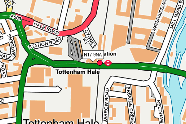
N17 9NA is located in the Tottenham Hale electoral ward, within the London borough of Haringey and the English Parliamentary constituency of Tottenham. The Sub Integrated Care Board (ICB) Location is NHS North Central London ICB - 93C and the police force is Metropolitan Police. This postcode has been in use since May 2014.


GetTheData
Source: OS OpenMap – Local (Ordnance Survey)
Source: OS VectorMap District (Ordnance Survey)
Licence: Open Government Licence (requires attribution)
| Easting | 534475 |
| Northing | 189477 |
| Latitude | 51.588107 |
| Longitude | -0.060299 |
GetTheData
Source: Open Postcode Geo
Licence: Open Government Licence
| Country | England |
| Postcode District | N17 |
| ➜ N17 open data dashboard ➜ See where N17 is on a map | |
GetTheData
Source: Land Registry Price Paid Data
Licence: Open Government Licence
Elevation or altitude of N17 9NA as distance above sea level:
| Metres | Feet | |
|---|---|---|
| Elevation | 10m | 33ft |
Elevation is measured from the approximate centre of the postcode, to the nearest point on an OS contour line from OS Terrain 50, which has contour spacing of ten vertical metres.
➜ How high above sea level am I? Find the elevation of your current position using your device's GPS.
GetTheData
Source: Open Postcode Elevation
Licence: Open Government Licence
| Ward | Tottenham Hale |
| Constituency | Tottenham |
GetTheData
Source: ONS Postcode Database
Licence: Open Government Licence
| June 2022 | Anti-social behaviour | On or near Parking Area | 103m |
| June 2022 | Anti-social behaviour | On or near Parking Area | 103m |
| June 2022 | Other crime | On or near Parking Area | 103m |
| ➜ Get more crime data in our Crime section | |||
GetTheData
Source: data.police.uk
Licence: Open Government Licence
| Tottenham Hale Bus Station | Tottenham Hale | 32m |
| Tottenham Hale Bus Station | Tottenham Hale | 50m |
| Tottenham Hale Bus Station | Tottenham Hale | 52m |
| Tottenham Hale Bus Station | Tottenham Hale | 62m |
| Tottenham Hale Bus Station | Tottenham Hale | 72m |
| Tottenham Hale Underground Station | Tottenham Hale | 4m |
| Seven Sisters Underground Station | Seven Sisters | 1,004m |
| Blackhorse Road Underground Station | Blackhorse Road | 1,334m |
| Tottenham Hale Station | 0km |
| Bruce Grove Station | 0.9km |
| South Tottenham Station | 1.2km |
GetTheData
Source: NaPTAN
Licence: Open Government Licence
GetTheData
Source: ONS Postcode Database
Licence: Open Government Licence


➜ Get more ratings from the Food Standards Agency
GetTheData
Source: Food Standards Agency
Licence: FSA terms & conditions
| Last Collection | |||
|---|---|---|---|
| Location | Mon-Fri | Sat | Distance |
| Jarrow Road/Ferry Lane | 17:30 | 12:00 | 207m |
| Millmead Road N17 | 18:30 | 407m | |
| Chestnut Road/Fairbanks Road | 17:30 | 12:00 | 417m |
GetTheData
Source: Dracos
Licence: Creative Commons Attribution-ShareAlike
| Facility | Distance |
|---|---|
| The Gym Group (London Tottenham Hale) Lebus Street, London Health and Fitness Gym | 181m |
| Ferry Lane Cruyff Court Jarrow Road, Jarrow Road, Tottenham, London Artificial Grass Pitch | 313m |
| Welbourne Centre (Closed) Chesnut Road, London Sports Hall | 401m |
GetTheData
Source: Active Places
Licence: Open Government Licence
| School | Phase of Education | Distance |
|---|---|---|
| Ada National College for Digital Skills 1, Sutherland Street, Pimlico, London, SW1V 4LD | 16 plus | 343m |
| Ferry Lane Primary School Jarrow Road, Ferry Lane Estate, Tottenham, London, N17 9PP | Primary | 346m |
| Harris Academy Tottenham Ashley Road, Tottenham, London, N17 9LN | All-through | 357m |
GetTheData
Source: Edubase
Licence: Open Government Licence
| Risk of N17 9NA flooding from rivers and sea | Low |
| ➜ N17 9NA flood map | |
GetTheData
Source: Open Flood Risk by Postcode
Licence: Open Government Licence
The below table lists the International Territorial Level (ITL) codes (formerly Nomenclature of Territorial Units for Statistics (NUTS) codes) and Local Administrative Units (LAU) codes for N17 9NA:
| ITL 1 Code | Name |
|---|---|
| TLI | London |
| ITL 2 Code | Name |
| TLI4 | Inner London - East |
| ITL 3 Code | Name |
| TLI43 | Haringey and Islington |
| LAU 1 Code | Name |
| E09000014 | Haringey |
GetTheData
Source: ONS Postcode Directory
Licence: Open Government Licence
The below table lists the Census Output Area (OA), Lower Layer Super Output Area (LSOA), and Middle Layer Super Output Area (MSOA) for N17 9NA:
| Code | Name | |
|---|---|---|
| OA | E00010450 | |
| LSOA | E01002080 | Haringey 015D |
| MSOA | E02000411 | Haringey 015 |
GetTheData
Source: ONS Postcode Directory
Licence: Open Government Licence
| N17 9PP | Jarrow Road | 164m |
| N17 9LR | Station Road | 182m |
| N17 9FG | Ferry Lane | 186m |
| N17 9PA | Erskine Crescent | 187m |
| N17 9FJ | Lebus Street | 191m |
| N17 9FN | Lebus Street | 191m |
| N17 9FH | Mill Mead Road | 197m |
| N17 9PR | Erskine Crescent | 203m |
| N17 9GE | Waterside Way | 213m |
| N17 9GD | Waterside Way | 235m |
GetTheData
Source: Open Postcode Geo; Land Registry Price Paid Data
Licence: Open Government Licence