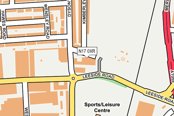
N17 0XR is located in the Northumberland Park electoral ward, within the London borough of Haringey and the English Parliamentary constituency of Tottenham. The Sub Integrated Care Board (ICB) Location is NHS North Central London ICB - 93C and the police force is Metropolitan Police. This postcode has been in use since February 1990.


GetTheData
Source: OS OpenMap – Local (Ordnance Survey)
Source: OS VectorMap District (Ordnance Survey)
Licence: Open Government Licence (requires attribution)
| Easting | 534868 |
| Northing | 191717 |
| Latitude | 51.608144 |
| Longitude | -0.053744 |
GetTheData
Source: Open Postcode Geo
Licence: Open Government Licence
| Country | England |
| Postcode District | N17 |
| ➜ N17 open data dashboard ➜ See where N17 is on a map | |
GetTheData
Source: Land Registry Price Paid Data
Licence: Open Government Licence
Elevation or altitude of N17 0XR as distance above sea level:
| Metres | Feet | |
|---|---|---|
| Elevation | 10m | 33ft |
Elevation is measured from the approximate centre of the postcode, to the nearest point on an OS contour line from OS Terrain 50, which has contour spacing of ten vertical metres.
➜ How high above sea level am I? Find the elevation of your current position using your device's GPS.
GetTheData
Source: Open Postcode Elevation
Licence: Open Government Licence
| Ward | Northumberland Park |
| Constituency | Tottenham |
GetTheData
Source: ONS Postcode Database
Licence: Open Government Licence
| January 2024 | Burglary | On or near Hawes Road | 324m |
| January 2024 | Criminal damage and arson | On or near Hawes Road | 324m |
| January 2024 | Vehicle crime | On or near Hawes Road | 324m |
| ➜ Get more crime data in our Crime section | |||
GetTheData
Source: data.police.uk
Licence: Open Government Licence
| Leeside Road (Willoughby Lane) | Northumberland Park | 136m |
| Leeside Road (Willoughby Lane) | Northumberland Park | 205m |
| Sedge Road (Watermead Way) | Northumberland Park | 406m |
| Glover Drive Tesco (Glover Drive) | Upper Edmonton | 450m |
| Glover Drive Ikea | Upper Edmonton | 453m |
| Angel Road Station | 0.6km |
| Northumberland Park Station | 0.7km |
| Silver Street Station | 1.2km |
GetTheData
Source: NaPTAN
Licence: Open Government Licence
GetTheData
Source: ONS Postcode Database
Licence: Open Government Licence


➜ Get more ratings from the Food Standards Agency
GetTheData
Source: Food Standards Agency
Licence: FSA terms & conditions
| Last Collection | |||
|---|---|---|---|
| Location | Mon-Fri | Sat | Distance |
| Leeside Road | 17:30 | 12:00 | 13m |
| Brantwood Road | 18:30 | 291m | |
| 23 Dysons Road | 17:30 | 12:00 | 344m |
GetTheData
Source: Dracos
Licence: Creative Commons Attribution-ShareAlike
| Facility | Distance |
|---|---|
| Frederick Knight Sports Ground Willoughby Lane, Tottenham, London Grass Pitches | 176m |
| Powerleague (Tottenham) Willoughby Lane, London Artificial Grass Pitch | 178m |
| The Hanlon Centre (Closed) Dysons Road, London Health and Fitness Gym | 464m |
GetTheData
Source: Active Places
Licence: Open Government Licence
| School | Phase of Education | Distance |
|---|---|---|
| Meridian Angel Primary School Albany Road, London, Edmonton, N18 2DX | Primary | 396m |
| Lea Valley Primary School Somerford Grove, London, N17 0PT | Primary | 684m |
| Raynham Primary School Raynham Avenue, London, N18 2JQ | Primary | 736m |
GetTheData
Source: Edubase
Licence: Open Government Licence
| Risk of N17 0XR flooding from rivers and sea | Low |
| ➜ N17 0XR flood map | |
GetTheData
Source: Open Flood Risk by Postcode
Licence: Open Government Licence
The below table lists the International Territorial Level (ITL) codes (formerly Nomenclature of Territorial Units for Statistics (NUTS) codes) and Local Administrative Units (LAU) codes for N17 0XR:
| ITL 1 Code | Name |
|---|---|
| TLI | London |
| ITL 2 Code | Name |
| TLI4 | Inner London - East |
| ITL 3 Code | Name |
| TLI43 | Haringey and Islington |
| LAU 1 Code | Name |
| E09000014 | Haringey |
GetTheData
Source: ONS Postcode Directory
Licence: Open Government Licence
The below table lists the Census Output Area (OA), Lower Layer Super Output Area (LSOA), and Middle Layer Super Output Area (MSOA) for N17 0XR:
| Code | Name | |
|---|---|---|
| OA | E00010245 | |
| LSOA | E01002037 | Haringey 002B |
| MSOA | E02000398 | Haringey 002 |
GetTheData
Source: ONS Postcode Directory
Licence: Open Government Licence
| N17 0SQ | Willoughby Lane | 51m |
| N17 0RY | Willoughby Lane | 73m |
| N17 0RU | Willoughby Lane | 103m |
| N18 2DN | Kimberley Road | 166m |
| N18 2DL | Dysons Road | 176m |
| N18 2BB | Malham Terrace | 196m |
| N18 2SA | Middleham Road | 207m |
| N17 0RT | Willoughby Lane | 209m |
| N18 2BD | Wensley Road | 211m |
| N17 0XJ | Hotspur Industrial Estate | 219m |
GetTheData
Source: Open Postcode Geo; Land Registry Price Paid Data
Licence: Open Government Licence