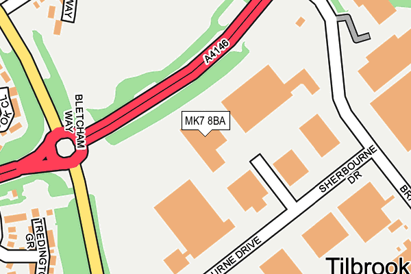
MK7 8BA is located in the Danesborough & Walton electoral ward, within the unitary authority of Milton Keynes and the English Parliamentary constituency of Milton Keynes South. The Sub Integrated Care Board (ICB) Location is NHS Bedfordshire, Luton and Milton Keynes ICB - M1J4Y and the police force is Thames Valley. This postcode has been in use since February 2011.


GetTheData
Source: OS OpenMap – Local (Ordnance Survey)
Source: OS VectorMap District (Ordnance Survey)
Licence: Open Government Licence (requires attribution)
| Easting | 489841 |
| Northing | 235693 |
| Latitude | 52.012404 |
| Longitude | -0.692389 |
GetTheData
Source: Open Postcode Geo
Licence: Open Government Licence
| Country | England |
| Postcode District | MK7 |
| ➜ MK7 open data dashboard ➜ See where MK7 is on a map ➜ Where is Milton Keynes? | |
GetTheData
Source: Land Registry Price Paid Data
Licence: Open Government Licence
Elevation or altitude of MK7 8BA as distance above sea level:
| Metres | Feet | |
|---|---|---|
| Elevation | 70m | 230ft |
Elevation is measured from the approximate centre of the postcode, to the nearest point on an OS contour line from OS Terrain 50, which has contour spacing of ten vertical metres.
➜ How high above sea level am I? Find the elevation of your current position using your device's GPS.
GetTheData
Source: Open Postcode Elevation
Licence: Open Government Licence
| Ward | Danesborough & Walton |
| Constituency | Milton Keynes South |
GetTheData
Source: ONS Postcode Database
Licence: Open Government Licence
| July 2023 | Violence and sexual offences | On or near Parking Area | 383m |
| July 2023 | Other theft | On or near Parking Area | 383m |
| June 2023 | Violence and sexual offences | On or near Parking Area | 383m |
| ➜ Get more crime data in our Crime section | |||
GetTheData
Source: data.police.uk
Licence: Open Government Licence
| Bradbourne Drive (Bletcham Way H10) | Tilbrook | 164m |
| Bradbourne Drive (Bletcham Way H10) | Tilbrook | 176m |
| Tilbrook Industrial Estate (Bradbourne Drive) | Caldecotte | 201m |
| Bourton Low | Walnut Tree | 302m |
| Bletcham Way (Bourton Low) | Walnut Tree | 305m |
| Bow Brickhill Station | 0.9km |
| Fenny Stratford Station | 2.1km |
| Woburn Sands Station | 2.7km |
GetTheData
Source: NaPTAN
Licence: Open Government Licence
GetTheData
Source: ONS Postcode Database
Licence: Open Government Licence


➜ Get more ratings from the Food Standards Agency
GetTheData
Source: Food Standards Agency
Licence: FSA terms & conditions
| Last Collection | |||
|---|---|---|---|
| Location | Mon-Fri | Sat | Distance |
| Bradbourne Drive | 19:15 | 12:00 | 237m |
| Bradbourne Drive | 18:30 | 244m | |
| Caldecotte Lane | 17:40 | 11:00 | 381m |
GetTheData
Source: Dracos
Licence: Creative Commons Attribution-ShareAlike
| Facility | Distance |
|---|---|
| Walnut Tree Sports Ground Bourton Low, Walnut Tree, Milton Keynes Grass Pitches | 279m |
| Heronsgate School Lichfield Down, Walnut Tree, Milton Keynes Grass Pitches | 437m |
| Browns Wood Sports Ground Browns Wood, Milton Keynes Grass Pitches, Cycling | 647m |
GetTheData
Source: Active Places
Licence: Open Government Licence
| School | Phase of Education | Distance |
|---|---|---|
| Heronshaw School Lichfield Down, Walnut Tree, Milton Keynes, MK7 7PG | Primary | 427m |
| Heronsgate School Lichfield Down, Walnut Tree, Milton Keynes, MK7 7BW | Primary | 437m |
| Walton High Fyfield Barrow, Walnut Tree, Milton Keynes, MK7 7WH | Secondary | 949m |
GetTheData
Source: Edubase
Licence: Open Government Licence
| Risk of MK7 8BA flooding from rivers and sea | Medium |
| ➜ MK7 8BA flood map | |
GetTheData
Source: Open Flood Risk by Postcode
Licence: Open Government Licence
The below table lists the International Territorial Level (ITL) codes (formerly Nomenclature of Territorial Units for Statistics (NUTS) codes) and Local Administrative Units (LAU) codes for MK7 8BA:
| ITL 1 Code | Name |
|---|---|
| TLJ | South East (England) |
| ITL 2 Code | Name |
| TLJ1 | Berkshire, Buckinghamshire and Oxfordshire |
| ITL 3 Code | Name |
| TLJ12 | Milton Keynes |
| LAU 1 Code | Name |
| E06000042 | Milton Keynes |
GetTheData
Source: ONS Postcode Directory
Licence: Open Government Licence
The below table lists the Census Output Area (OA), Lower Layer Super Output Area (LSOA), and Middle Layer Super Output Area (MSOA) for MK7 8BA:
| Code | Name | |
|---|---|---|
| OA | E00084863 | |
| LSOA | E01016827 | Milton Keynes 022D |
| MSOA | E02003480 | Milton Keynes 022 |
GetTheData
Source: ONS Postcode Directory
Licence: Open Government Licence
| MK7 8AT | Bradbourne Drive | 174m |
| MK7 7AP | Caraway Close | 294m |
| MK7 7JA | Cook Close | 304m |
| MK7 8LR | Tredington Grove | 309m |
| MK7 8LW | Wadesmill Lane | 318m |
| MK7 7DE | Bourton Low | 327m |
| MK7 7HU | Rixband Close | 341m |
| MK7 7DF | Bourton Low | 349m |
| MK7 7ED | Wadesmill Lane | 355m |
| MK7 7BX | Lichfield Down | 357m |
GetTheData
Source: Open Postcode Geo; Land Registry Price Paid Data
Licence: Open Government Licence