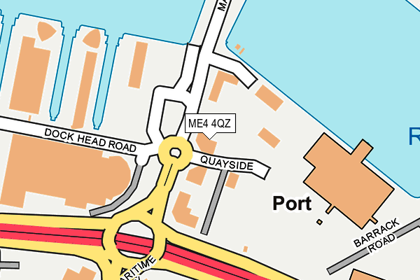
ME4 4QZ is located in the St Mary's Island electoral ward, within the unitary authority of Medway and the English Parliamentary constituency of Rochester and Strood. The Sub Integrated Care Board (ICB) Location is NHS Kent and Medway ICB - 91Q and the police force is Kent. This postcode has been in use since December 1996.


GetTheData
Source: OS OpenMap – Local (Ordnance Survey)
Source: OS VectorMap District (Ordnance Survey)
Licence: Open Government Licence (requires attribution)
| Easting | 576621 |
| Northing | 169981 |
| Latitude | 51.401360 |
| Longitude | 0.537776 |
GetTheData
Source: Open Postcode Geo
Licence: Open Government Licence
| Country | England |
| Postcode District | ME4 |
| ➜ ME4 open data dashboard ➜ See where ME4 is on a map ➜ Where is Gillingham? | |
GetTheData
Source: Land Registry Price Paid Data
Licence: Open Government Licence
Elevation or altitude of ME4 4QZ as distance above sea level:
| Metres | Feet | |
|---|---|---|
| Elevation | 0m | 0ft |
Elevation is measured from the approximate centre of the postcode, to the nearest point on an OS contour line from OS Terrain 50, which has contour spacing of ten vertical metres.
➜ How high above sea level am I? Find the elevation of your current position using your device's GPS.
GetTheData
Source: Open Postcode Elevation
Licence: Open Government Licence
| Ward | St Mary's Island |
| Constituency | Rochester And Strood |
GetTheData
Source: ONS Postcode Database
Licence: Open Government Licence
| June 2023 | Anti-social behaviour | On or near Park/Open Space | 231m |
| June 2022 | Violence and sexual offences | On or near Quayside | 40m |
| June 2022 | Vehicle crime | On or near Quayside | 40m |
| ➜ Get more crime data in our Crime section | |||
GetTheData
Source: data.police.uk
Licence: Open Government Licence
| Ship And Trades (Maritime Way) | Chatham Maritime | 42m |
| Ship And Trades (Maritime Way) | Chatham Maritime | 104m |
| Dockside Outlet (Dockhead Road) | Chatham Maritime | 179m |
| Dockside Outlet (Dockhead Road) | Chatham Maritime | 328m |
| Dockside Outlet (Dock Head Road) | Chatham Maritime | 342m |
| Gillingham (Kent) Station | 1.8km |
| Rochester Station | 2.6km |
| Chatham Station | 2.6km |
GetTheData
Source: NaPTAN
Licence: Open Government Licence
GetTheData
Source: ONS Postcode Database
Licence: Open Government Licence


➜ Get more ratings from the Food Standards Agency
GetTheData
Source: Food Standards Agency
Licence: FSA terms & conditions
| Last Collection | |||
|---|---|---|---|
| Location | Mon-Fri | Sat | Distance |
| Dockhead Road | 17:30 | 11:00 | 271m |
| Pembroke Gate | 17:30 | 11:30 | 445m |
| St Marys Island | 17:30 | 11:30 | 478m |
GetTheData
Source: Dracos
Licence: Creative Commons Attribution-ShareAlike
| Facility | Distance |
|---|---|
| Trugym (Chatham) Dock Head Road, Chatham Maritime, Chatham Health and Fitness Gym, Studio | 201m |
| Puregym (Chatham) Leviathan Way, Chatham Maritime, Chatham Health and Fitness Gym, Studio | 356m |
| Medway Sports Hall Central Avenue, Chatham Sports Hall, Health and Fitness Gym, Outdoor Tennis Courts | 473m |
GetTheData
Source: Active Places
Licence: Open Government Licence
| School | Phase of Education | Distance |
|---|---|---|
| St Mary's Island Church of England (Aided) Primary School Island Way West, St Mary's Island, Chatham, ME4 3ST | Primary | 703m |
| Waterfront UTC South Side Three Road, Chatham, ME4 4FQ | Secondary | 863m |
| MidKent College Medway Road, Gillingham, ME7 1FN | 16 plus | 905m |
GetTheData
Source: Edubase
Licence: Open Government Licence
| Risk of ME4 4QZ flooding from rivers and sea | Low |
| ➜ ME4 4QZ flood map | |
GetTheData
Source: Open Flood Risk by Postcode
Licence: Open Government Licence
The below table lists the International Territorial Level (ITL) codes (formerly Nomenclature of Territorial Units for Statistics (NUTS) codes) and Local Administrative Units (LAU) codes for ME4 4QZ:
| ITL 1 Code | Name |
|---|---|
| TLJ | South East (England) |
| ITL 2 Code | Name |
| TLJ4 | Kent |
| ITL 3 Code | Name |
| TLJ41 | Medway |
| LAU 1 Code | Name |
| E06000035 | Medway |
GetTheData
Source: ONS Postcode Directory
Licence: Open Government Licence
The below table lists the Census Output Area (OA), Lower Layer Super Output Area (LSOA), and Middle Layer Super Output Area (MSOA) for ME4 4QZ:
| Code | Name | |
|---|---|---|
| OA | E00081433 | |
| LSOA | E01032798 | Medway 007E |
| MSOA | E02003320 | Medway 007 |
GetTheData
Source: ONS Postcode Directory
Licence: Open Government Licence
| ME4 3ER | Maritime Way | 158m |
| ME4 4ZL | Dock Head Road | 201m |
| ME4 4ZN | Dock Head Road | 201m |
| ME4 4ZS | Dock Head Road | 201m |
| ME4 4ZH | Chatham Quays | 217m |
| ME4 4ZE | Chatham Quays | 281m |
| ME4 4ZF | Chatham Quays | 281m |
| ME4 3SB | Sandling Way | 349m |
| ME4 3LA | Marine View | 350m |
| ME4 3HB | Watersmeet | 372m |
GetTheData
Source: Open Postcode Geo; Land Registry Price Paid Data
Licence: Open Government Licence