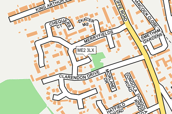
ME2 3LX lies on Sherbourne Drive in Strood, Rochester. ME2 3LX is located in the Strood North & Frindsbury electoral ward, within the unitary authority of Medway and the English Parliamentary constituency of Rochester and Strood. The Sub Integrated Care Board (ICB) Location is NHS Kent and Medway ICB - 91Q and the police force is Kent. This postcode has been in use since January 1992.


GetTheData
Source: OS OpenMap – Local (Ordnance Survey)
Source: OS VectorMap District (Ordnance Survey)
Licence: Open Government Licence (requires attribution)
| Easting | 573355 |
| Northing | 170125 |
| Latitude | 51.403661 |
| Longitude | 0.490913 |
GetTheData
Source: Open Postcode Geo
Licence: Open Government Licence
| Street | Sherbourne Drive |
| Locality | Strood |
| Town/City | Rochester |
| Country | England |
| Postcode District | ME2 |
➜ See where ME2 is on a map ➜ Where is Rochester? | |
GetTheData
Source: Land Registry Price Paid Data
Licence: Open Government Licence
Elevation or altitude of ME2 3LX as distance above sea level:
| Metres | Feet | |
|---|---|---|
| Elevation | 50m | 164ft |
Elevation is measured from the approximate centre of the postcode, to the nearest point on an OS contour line from OS Terrain 50, which has contour spacing of ten vertical metres.
➜ How high above sea level am I? Find the elevation of your current position using your device's GPS.
GetTheData
Source: Open Postcode Elevation
Licence: Open Government Licence
| Ward | Strood North & Frindsbury |
| Constituency | Rochester And Strood |
GetTheData
Source: ONS Postcode Database
Licence: Open Government Licence
2021 26 FEB £560,000 |
2019 31 OCT £520,000 |
2019 23 AUG £505,000 |
2017 12 DEC £510,000 |
2017 24 NOV £570,000 |
2003 28 FEB £317,000 |
2002 12 APR £268,000 |
1998 31 JUL £65,000 |
1998 20 JUL £166,000 |
1997 5 DEC £57,000 |
GetTheData
Source: HM Land Registry Price Paid Data
Licence: Contains HM Land Registry data © Crown copyright and database right 2025. This data is licensed under the Open Government Licence v3.0.
| Clarendon Drive (Cliffe Road) | Frindsbury | 214m |
| Clarendon Drive (Cliffe Road) | Frindsbury | 238m |
| King Arthurs Drive (Cliffe Road) | Frindsbury | 249m |
| King Arthurs Drive (Cliffe Road) | Frindsbury | 287m |
| Slatin Road (Cliffe Road) | Frindsbury | 327m |
| Strood Station | 1km |
| Rochester Station | 2.4km |
| Higham Station | 3.1km |
GetTheData
Source: NaPTAN
Licence: Open Government Licence
| Percentage of properties with Next Generation Access | 100.0% |
| Percentage of properties with Superfast Broadband | 100.0% |
| Percentage of properties with Ultrafast Broadband | 0.0% |
| Percentage of properties with Full Fibre Broadband | 0.0% |
Superfast Broadband is between 30Mbps and 300Mbps
Ultrafast Broadband is > 300Mbps
| Median download speed | 40.0Mbps |
| Average download speed | 39.9Mbps |
| Maximum download speed | 55.00Mbps |
| Median upload speed | 7.3Mbps |
| Average upload speed | 6.9Mbps |
| Maximum upload speed | 9.84Mbps |
| Percentage of properties unable to receive 2Mbps | 0.0% |
| Percentage of properties unable to receive 5Mbps | 0.0% |
| Percentage of properties unable to receive 10Mbps | 0.0% |
| Percentage of properties unable to receive 30Mbps | 0.0% |
GetTheData
Source: Ofcom
Licence: Ofcom Terms of Use (requires attribution)
GetTheData
Source: ONS Postcode Database
Licence: Open Government Licence


➜ Get more ratings from the Food Standards Agency
GetTheData
Source: Food Standards Agency
Licence: FSA terms & conditions
| Last Collection | |||
|---|---|---|---|
| Location | Mon-Fri | Sat | Distance |
| Goddington Road | 17:30 | 11:30 | 289m |
| Windmill Street | 17:30 | 11:30 | 417m |
| Brompton Lane | 17:30 | 11:30 | 423m |
GetTheData
Source: Dracos
Licence: Creative Commons Attribution-ShareAlike
The below table lists the International Territorial Level (ITL) codes (formerly Nomenclature of Territorial Units for Statistics (NUTS) codes) and Local Administrative Units (LAU) codes for ME2 3LX:
| ITL 1 Code | Name |
|---|---|
| TLJ | South East (England) |
| ITL 2 Code | Name |
| TLJ4 | Kent |
| ITL 3 Code | Name |
| TLJ41 | Medway |
| LAU 1 Code | Name |
| E06000035 | Medway |
GetTheData
Source: ONS Postcode Directory
Licence: Open Government Licence
The below table lists the Census Output Area (OA), Lower Layer Super Output Area (LSOA), and Middle Layer Super Output Area (MSOA) for ME2 3LX:
| Code | Name | |
|---|---|---|
| OA | E00081561 | |
| LSOA | E01016134 | Medway 005B |
| MSOA | E02003318 | Medway 005 |
GetTheData
Source: ONS Postcode Directory
Licence: Open Government Licence
| ME2 3LU | Richborough Drive | 63m |
| ME2 3ND | Merryfields | 66m |
| ME2 3LT | Clarendon Drive | 87m |
| ME2 3NE | Brasted Court | 122m |
| ME2 3NG | Chequers Court | 123m |
| ME2 3LW | Morland Drive | 131m |
| ME2 3AS | Kitchener Road | 143m |
| ME2 3NR | Goldsworth Drive | 148m |
| ME2 3LY | Lychfield Drive | 161m |
| ME2 3DN | Cliffe Road | 171m |
GetTheData
Source: Open Postcode Geo; Land Registry Price Paid Data
Licence: Open Government Licence