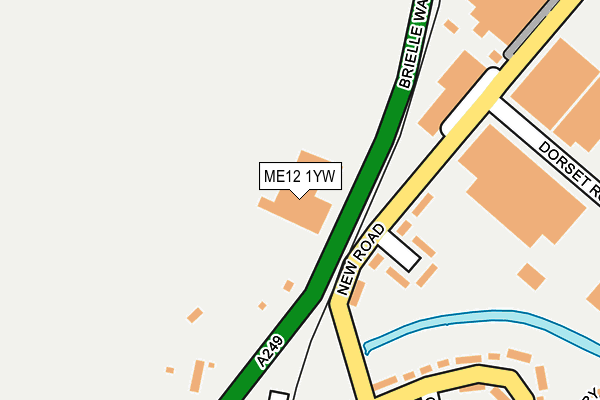
ME12 1YW is located in the Sheerness electoral ward, within the local authority district of Swale and the English Parliamentary constituency of Sittingbourne and Sheppey. The Sub Integrated Care Board (ICB) Location is NHS Kent and Medway ICB - 91Q and the police force is Kent. This postcode has been in use since December 1994.


GetTheData
Source: OS OpenMap – Local (Ordnance Survey)
Source: OS VectorMap District (Ordnance Survey)
Licence: Open Government Licence (requires attribution)
| Easting | 590973 |
| Northing | 173879 |
| Latitude | 51.431723 |
| Longitude | 0.745927 |
GetTheData
Source: Open Postcode Geo
Licence: Open Government Licence
| Country | England |
| Postcode District | ME12 |
| ➜ ME12 open data dashboard ➜ See where ME12 is on a map ➜ Where is Sheerness? | |
GetTheData
Source: Land Registry Price Paid Data
Licence: Open Government Licence
Elevation or altitude of ME12 1YW as distance above sea level:
| Metres | Feet | |
|---|---|---|
| Elevation | 0m | 0ft |
Elevation is measured from the approximate centre of the postcode, to the nearest point on an OS contour line from OS Terrain 50, which has contour spacing of ten vertical metres.
➜ How high above sea level am I? Find the elevation of your current position using your device's GPS.
GetTheData
Source: Open Postcode Elevation
Licence: Open Government Licence
| Ward | Sheerness |
| Constituency | Sittingbourne And Sheppey |
GetTheData
Source: ONS Postcode Database
Licence: Open Government Licence
| June 2022 | Other theft | On or near Queensway | 218m |
| June 2022 | Violence and sexual offences | On or near Coats Avenue | 318m |
| June 2022 | Violence and sexual offences | On or near Coats Avenue | 318m |
| ➜ Get more crime data in our Crime section | |||
GetTheData
Source: data.police.uk
Licence: Open Government Licence
| Queensway (New Road) | West Minster | 190m |
| Dorset Road (New Road) | West Minster | 208m |
| Dorset Road (New Road) | West Minster | 264m |
| Pacific Windows Works (Brielle Way) | West Minster | 343m |
| Pacific Windows Works (Brielle Way) | West Minster | 350m |
| Sheerness-on-Sea Station | 1.4km |
| Queenborough Station | 1.8km |
| Swale Station | 4.7km |
GetTheData
Source: NaPTAN
Licence: Open Government Licence
GetTheData
Source: ONS Postcode Database
Licence: Open Government Licence


➜ Get more ratings from the Food Standards Agency
GetTheData
Source: Food Standards Agency
Licence: FSA terms & conditions
| Last Collection | |||
|---|---|---|---|
| Location | Mon-Fri | Sat | Distance |
| Queensway Post Office | 17:30 | 12:00 | 348m |
| Edenbridge Road | 17:00 | 11:30 | 982m |
| Hope Street | 17:00 | 11:45 | 1,080m |
GetTheData
Source: Dracos
Licence: Creative Commons Attribution-ShareAlike
| Facility | Distance |
|---|---|
| Co-op Sports And Social Club St. Georges Avenue, Sheerness Grass Pitches | 795m |
| Festival Playing Field New Road, Sheerness Grass Pitches | 899m |
| Rose Street Primary School Rose Street, Sheerness Grass Pitches | 1.1km |
GetTheData
Source: Active Places
Licence: Open Government Licence
| School | Phase of Education | Distance |
|---|---|---|
| West Minster Primary School St George's Avenue, Sheerness, ME12 1ET | Primary | 551m |
| St Edward's Catholic Primary School New Road, Sheerness, ME12 1BW | Primary | 1km |
| Rose Street Primary School Rose Street, Sheerness, ME12 1AW | Primary | 1.2km |
GetTheData
Source: Edubase
Licence: Open Government Licence
| Risk of ME12 1YW flooding from rivers and sea | Low |
| ➜ ME12 1YW flood map | |
GetTheData
Source: Open Flood Risk by Postcode
Licence: Open Government Licence
The below table lists the International Territorial Level (ITL) codes (formerly Nomenclature of Territorial Units for Statistics (NUTS) codes) and Local Administrative Units (LAU) codes for ME12 1YW:
| ITL 1 Code | Name |
|---|---|
| TLJ | South East (England) |
| ITL 2 Code | Name |
| TLJ4 | Kent |
| ITL 3 Code | Name |
| TLJ43 | Kent Thames Gateway |
| LAU 1 Code | Name |
| E07000113 | Swale |
GetTheData
Source: ONS Postcode Directory
Licence: Open Government Licence
The below table lists the Census Output Area (OA), Lower Layer Super Output Area (LSOA), and Middle Layer Super Output Area (MSOA) for ME12 1YW:
| Code | Name | |
|---|---|---|
| OA | E00124930 | |
| LSOA | E01024615 | Swale 002C |
| MSOA | E02005116 | Swale 002 |
GetTheData
Source: ONS Postcode Directory
Licence: Open Government Licence
| ME12 1LN | New Road | 98m |
| ME12 1LW | Nelson Close | 146m |
| ME12 1LJ | Queens Way | 201m |
| ME12 1LE | Coats Avenue | 284m |
| ME12 1LL | Queens Way | 284m |
| ME12 1LH | Queens Way | 285m |
| ME12 1LQ | Queens Way | 398m |
| ME12 1LF | Queens Way | 405m |
| ME12 1LD | Queens Way | 406m |
| ME12 1LA | Almond Tree Close | 438m |
GetTheData
Source: Open Postcode Geo; Land Registry Price Paid Data
Licence: Open Government Licence